Tropical Storm Cindy is Named
 ed to 54 knots at the Green Canyon oil rig in the northern Gulf about 100 miles south of Lafayette.
FAST FACTS
SUMMARY OF 100 PM CDT…1800 UTC…INFORMATION
———————————————-
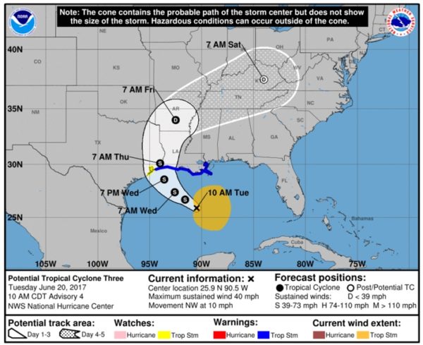
LOCATION…25.9N 90.5W
ABOUT 265 MI…430 KM S OF MORGAN CITY LOUISIANA
ABOUT 355 MI…565 KM SE OF GALVESTON TEXAS
MAXIMUM SUSTAINED WINDS…45 MPH…75 KM/H
PRESENT MOVEMENT…STATIONARY
MINIMUM CENTRAL PRESSURE…999 MB…29.50 INCHES
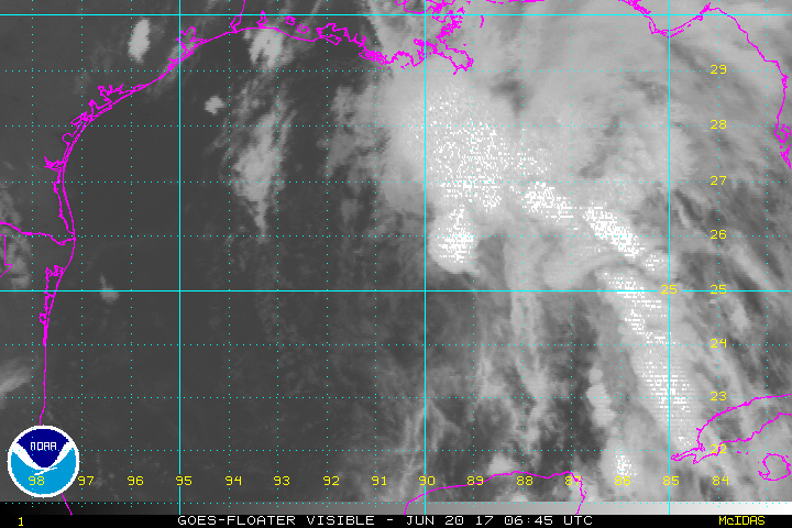
Satellite imagery indicates convection continues to try to develop on the northern side of the broad low pressure center, but it is being blown off to the north and northeast by the strong winds aloft around an upper level low off the Texas Coast.
The storm is basically stationary now, so it has time to get its act together before it makes landfall late Wednesday night near the Texas/Louisiana border.
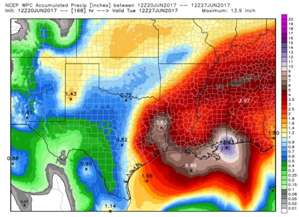
The impacts from Cindy will largely happen to the east of the center. This means bad weather for not only the Upper Texas Coast and Southwest Louisiana, but all of the Louisiana, Mississippi and Alabama coasts into Northwest Florida. The heavy rain will also affect inland areas. Flash flood watches are in effect.
Here are official rainfall forecasts from the WPC:
Coastal flood warnings, high surf advisories and rip current alerts are also in effect all along these states’ coastlines.
Tropical storm watches are in effect for parts of the Upper Texas Coast and Tropical Storm Warnings are in effect for the far Upper Texas Coast and all of the Louisiana Coast. The highest threat of tropical storm force winds (39 mph or greater) will be from the Houston/Galveston area back to around Lafayette and Morgan City on the Central Louisiana coast.
Storm surge will run about 2 feet along and east of the center.
This is only the fourth time in recorded Atlantic Hurricane history that there were two tropical storms in progress at the same time in the Atlantic in June.
Here is the full text of the rest of the 1 p.m. advisory:
WATCHES AND WARNINGS
——————–
CHANGES WITH THIS ADVISORY:
None.
SUMMARY OF WATCHES AND WARNINGS IN EFFECT:
A Tropical Storm Warning is in effect for…
* High Island to the Mouth of the Pearl River
A Tropical Storm Watch is in effect for…
* West of High Island to San Luis Pass
A Tropical Storm Warning means that tropical storm conditions are
expected somewhere within the warning area, in this case within the
next 24 to 36 hours.
A Tropical Storm Watch means that tropical storm conditions are
possible within the watch area, generally within 48 hours.
Interests elsewhere along the U.S. Gulf Coast from the central Texas
coast to the western Florida Panhandle should monitor the progress
of this system.
For storm information specific to your area, including possible
inland watches and warnings, please monitor products issued by your
local National Weather Service forecast office.
DISCUSSION AND 48-HOUR OUTLOOK
——————————
Satellite imagery, aircraft data, and surface observations indicate
that the low pressure system in the central Gulf of Mexico has
acquired a well-defined center, and is now Tropical Storm Cindy, the
third tropical storm of 2017.
At 100 PM CDT (1800 UTC), the center of Tropical Storm Cindy was
centered near latitude 25.9 North, longitude 90.5 West. Cindy has
been stationary for the past few hours, but the system is expected
to resume a motion toward the northwest at around 10 mph (17 km/h)
later today, and this motion is expected to continue through
Wednesday night. A turn toward the north-northwest is forecast early
Thursday. On the forecast track, Cindy is expected to approach
the coast of southwest Louisiana late Wednesday or Wednesday night,
and move inland over western Louisiana and eastern Texas on
Thursday.
Maximum sustained winds are near 45 mph (75 km/h) with higher
gusts. Little change in strength is forecast before the system
reaches the coast on Thursday.
Tropical-storm-force winds extend outward up to 205 miles (335 km),
mainly to the north and east of the center.
The estimated minimum central pressure is 999 mb (29.50 inches).
HAZARDS AFFECTING LAND
———————-
WIND: Tropical storm conditions are expected to first reach the
coast within the warning area later today and spread westward
within the warning area through Wednesday. Tropical storm
conditions are possible in the watch area on Wednesday.
RAINFALL: Cindy is expected to produce total rain accumulations of
6 to 9 inches with isolated maximum amounts of 12 inches over
southeastern Louisiana, southern Mississippi, southern Alabama, and
the Florida Panhandle through Thursday. Rainfall amounts of 3 to 5
inches with isolated maximum amounts of 6 inches can be expected
farther west across southwest Louisiana into southeast Texas through
Thursday.
STORM SURGE: Inundation of 1 to 3 feet above ground level is
possible along the coast in portions of the Tropical Storm Warning
area.
TORNADOES: A tornado or two is possible this afternoon and tonight
from south-central Louisiana to the western Florida Panhandle.
NEXT ADVISORY
————-
About the Author (Author Profile)
Bill Murray is the President of The Weather Factory. He is the site's official weather historian and a weekend forecaster. He also anchors the site's severe weather coverage. Bill Murray is the proud holder of National Weather Association Digital Seal #0001 @wxhistorianSubscribe
If you enjoyed this article, subscribe to receive more just like it.


