Cindy Weakens Slightly, Steady Rain Pushing Across Central Alabama
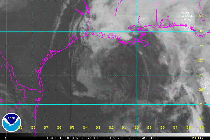
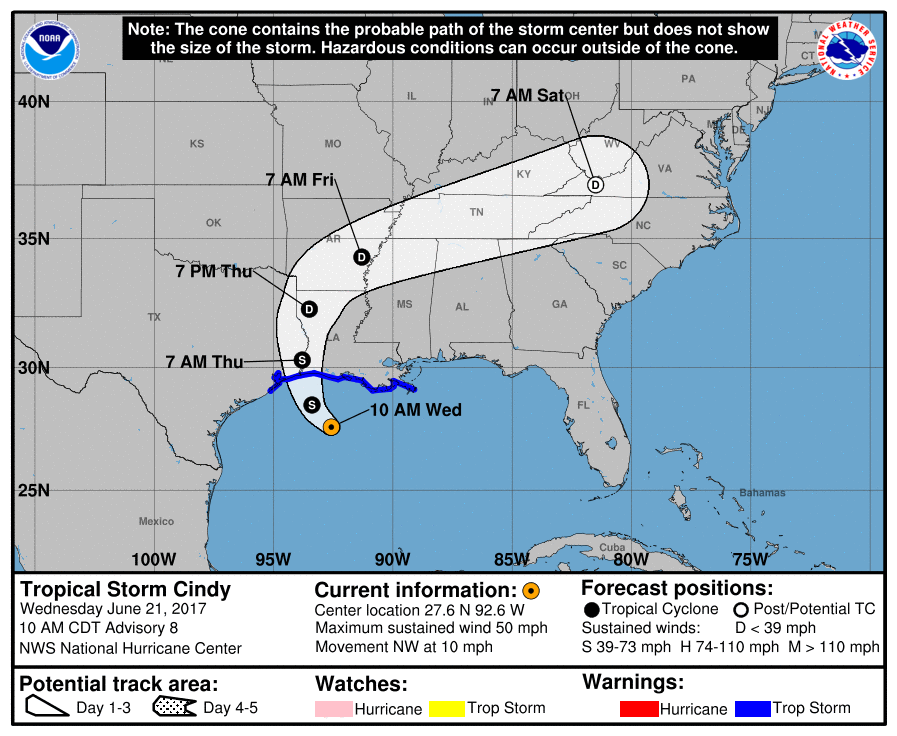
If you look at the fixes over the past three hours from the Air Force plane currently investigating Cindy, you might surmise that the storm has turned to the southwest. This is probably just transient centers rotating around a common center that still appears to be moving to the northwest. The NHC agrees with that idea and continues with a northwest motion at 10 mph.
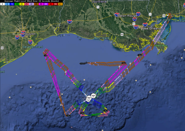
The last fix was at 8:51 a.m. CDT. The minimum pressure is holding steady at about 995-996 mb.
Maximum flight level winds on this last pass were 48 knots in the northwest quadrant. Powerful thunderstorms are evident in that northwestern quadrant, where the dry air has not been entrained still. There are widespread 35-45 knot flight level winds in the northern semicircle.
The NHC has dropped the tropical storm warning for areas north and east of the Mouth of the Mississippi River. That makes sense.
The landfall forecast has been adjusted ever so slight to the west, near Sabine Lake at the Texas/Louisiana border. Tropical storm force winds will overspread southern Louisiana and Southeast Texas as the center moves onshore around 3 a.m. tonight. The winds will be mainly in the heavier squalls.
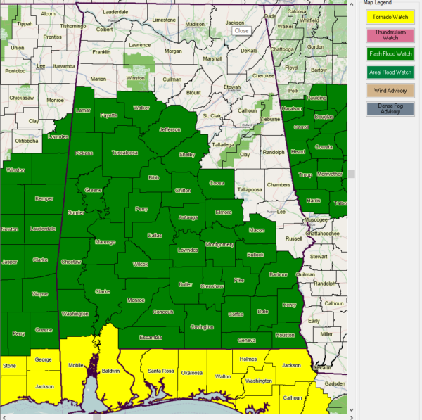
Flash Flood Watches cover areas from Northeast Texas to Alabama and Central Georgia. Here is a graphic of the flash flood watches and the tornado watches in our area.
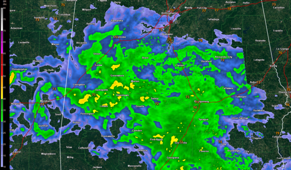
Across South Central Alabama a large area of stratiform rainfall is spreading northward. Rain is now spreading into Fayette, Walker, Jefferson, Shelby and Talladega Counties. The entire middle of the state should see about 3 hours of steady light to moderate rain.
There have been several tornado warnings along the Mississippi Coast but all that has calmed down in the past 30 minutes. A new tornado watch has just been issued for South Alabama, Northwest Florida, Southeast Louisiana and southern Mississippi. The severe threat will continue into South Alabama tonight with high shear values in place.
Central Alabama will have a severe weather threat on Friday as the center recurves and passes near Memphis and south of Nashville. This will put us in a favorable position for tornadoes. They will generally be the small spin up types, but they can cause damage.
10 AM CDT FAST FACTS
———————————————–
LOCATION…27.6N 92.6W
ABOUT 170 MI…270 KM SSW OF MORGAN CITY LOUISIANA
ABOUT 180 MI…285 KM SE OF GALVESTON TEXAS
MAXIMUM SUSTAINED WINDS…50 MPH…85 KM/H
PRESENT MOVEMENT…NW OR 310 DEGREES AT 10 MPH…17 KM/H
MINIMUM CENTRAL PRESSURE…996 MB…29.42 INCHES
Here is the full text of the rest of the advisory:
Watches And Warnings
——————–
Changes With This Advisory:
The Tropical Storm Warning Is Discontinued North And East Of The
Mouth Of The Mississippi River, Including Metropolitan New Orleans
And Lake Pontchartrain.
Summary Of Watches And Warnings In Effect:
A Tropical Storm Warning Is In Effect For…
* San Luis Pass Texas To The Mouth Of The Mississippi River
A Tropical Storm Warning Means That Tropical Storm Conditions Are
Expected Somewhere Within The Warning Area, In This Case Within The
Next 12 To 24 Hours.
Interests Elsewhere Along The U.s. Gulf Coast From The Central Texas
Coast To The Western Florida Panhandle Should Monitor The Progress
Of This System.
For Storm Information Specific To Your Area, Including Possible
Inland Watches And Warnings, Please Monitor Products Issued By Your
Local National Weather Service Forecast Office.
Discussion And 48-hour Outlook
——————————
At 1000 Am Cdt (1500 Utc), The Center Of Tropical Storm Cindy Was
Located Near Latitude 27.6 North, Longitude 92.6 West. Cindy Is
Moving Toward The Northwest Near 10 Mph (17 Km/h), And This Motion
Is Expected To Continue Today. A Turn Toward The North-northwest
And Then Toward The North Is Expected Tonight And Thursday. On
The Forecast Track, The Center Of Cindy Will Approach The Coast Of
Southwest Louisiana And Southeast Texas Late Today Or Tonight, And
Move Inland Over Southeastern Texas Or Southwestern Louisiana On
Thursday.
Surface Observations And Reports From An Air Force Reserve
Hurricane Hunter Aircraft Indicate That Maximum Sustained Winds Are
Now Near 50 Mph (85 Km/h) With Higher Gusts. Little Change In
Strength Is Expected Before Landfall, With Weakening
Expected Thereafter.
Tropical-storm-force Winds Extend Outward Up To 205 Miles (335 Km)
Mainly To The North And East Of The Center.
The Minimum Central Pressure Just Reported By The Hurricane Hunter
Aircraft Is 996 Mb (29.42 Inches).
Hazards Affecting Land
———————-
Rainfall: Cindy Is Expected To Produce Total Rain Accumulations Of
6 To 9 Inches With Isolated Maximum Amounts Of 12 Inches Over
Southeastern Louisiana, Southern Mississippi, Southern Alabama, And
Western Portions Of The Florida Panhandle Through Thursday. This
Rainfall Could Cause Life-threatening Flash Flooding In These Areas.
Rainfall Amounts Of 3 To 5 Inches With Isolated Maximum Amounts Of 7
Inches Can Be Expected Farther West Across Western Louisiana And
Eastern Texas Through Thursday. Rainfall Should Spread
Northeastward Across Arkansas And Into Portions Of The Tennessee And
Ohio Valleys Through Friday, With Total Rain Accumulations Of 3 To 5
Inches With Locally Higher Amounts Possible.
Wind: Tropical Storm Conditions Should Spread Westward And
Northward Through The Tropical Storm Warning Area Today Through
Thursday.
Storm Surge: Inundation Of 1 To 3 Feet Above Ground Level Is
Expected Along The Coast In Portions Of The Tropical Storm Warning
Area. Inundation Of 1 To 3 Feet Above Ground Level Is Also Possible
Elsewhere Along The Coast From Southeastern Louisiana To The Western
Florida Panhandle In Areas Of Strong Onshore Winds.
Tornadoes: A Few Tornadoes Are Possible Today Through Tonight From
The Western Florida Panhandle Across Southwest Alabama, Southern
Mississippi, And Southern Louisiana.
Next Advisory
————-
Next Intermediate Advisory At 100 Pm Cdt.
Next Complete Advisory At 400 Pm Cdt.
$$
Forecaster Beven
About the Author (Author Profile)
Bill Murray is the President of The Weather Factory. He is the site's official weather historian and a weekend forecaster. He also anchors the site's severe weather coverage. Bill Murray is the proud holder of National Weather Association Digital Seal #0001 @wxhistorianSubscribe
If you enjoyed this article, subscribe to receive more just like it.


