Watching Storms Southwest of Birmigham
LATE REPORT
1137 AM
The NWS in Birmingham gas issued a flood advisory for Walker and western Jefferson Counties until 230 pm CDT for these storms
ORIGINAL POST
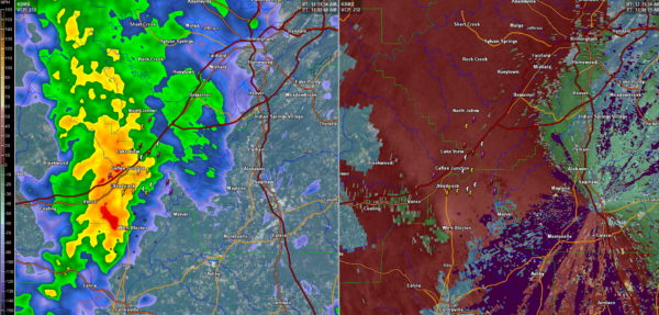
The cells along the feeder band southwest of Birmingham have intensified late this morning and have developed lightning.
The strongest cells are over northern Perry County moving into SW Bibb County and over northern Bibb County, moving into southwestern Jefferson County.
They will affect Bessemer and western parts of Jefferson County eventually reaching up into the Sumiton and Warrior areas of Walker and northern Jefferson County.
There is decent low level helicity in the atmosphere and we will be monitoring for any potential spin up tornadoes. There is some rotation west of West Blocton. This couplet will move toward Woodstock and Caffee Junction then toward Valley Creek, Hueytown and Pleasant Grove.
Category: Alabama's Weather, ALL POSTS
About the Author (Author Profile)
Bill Murray is the President of The Weather Factory. He is the site's official weather historian and a weekend forecaster. He also anchors the site's severe weather coverage. Bill Murray is the proud holder of National Weather Association Digital Seal #0001 @wxhistorianSubscribe
If you enjoyed this article, subscribe to receive more just like it.


