Tornado Warning Cancelled For Tallapoosa County
Rotation has broadened, but still keep an eye on this storm. Wouldn’t take much for it to tighten back up and cause another warning.
Severe Weather Statement
National Weather Service Birmingham AL
419 PM CDT THU JUN 22 2017
ALC123-222128-
/O.CAN.KBMX.TO.W.0042.000000T0000Z-170622T2130Z/
Tallapoosa AL-
419 PM CDT THU JUN 22 2017
…THE TORNADO WARNING FOR NORTHEASTERN TALLAPOOSA COUNTY IS
CANCELLED…
The storm which prompted the warning has weakened below severe
limits, and no longer appears capable of producing a tornado.
Therefore the warning has been cancelled.
A tornado watch remains in effect until 1000 PM CDT for east central
Alabama.
___________________________________
Severe Weather Statement
National Weather Service Birmingham AL
407 PM CDT THU JUN 22 2017
ALC123-222130-
/O.CON.KBMX.TO.W.0042.000000T0000Z-170622T2130Z/
Tallapoosa AL-
407 PM CDT THU JUN 22 2017
…A TORNADO WARNING REMAINS IN EFFECT UNTIL 430 PM CDT FOR
NORTHEASTERN TALLAPOOSA COUNTY…
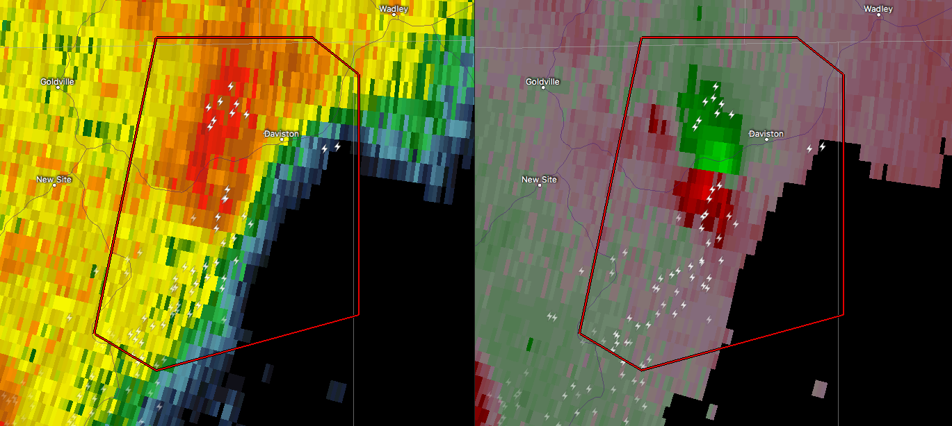
At 407 PM CDT, a severe thunderstorm capable of producing a tornado
was located near New Site, or 15 miles north of Dadeville, moving
northeast at 35 mph.
HAZARD…Tornado.
SOURCE…Radar indicated rotation.
IMPACT…Flying debris will be dangerous to those caught without
shelter. Mobile homes will be damaged or destroyed. Damage
to roofs, windows, and vehicles will occur. Tree damage is
likely.
Locations impacted include…
Daviston.
PRECAUTIONARY/PREPAREDNESS ACTIONS…
TAKE COVER NOW! Move to a basement or an interior room on the lowest
floor of a sturdy building. Avoid windows. If you are outdoors, in a
mobile home, or in a vehicle, move to the closest substantial shelter
and protect yourself from flying debris.
___________________________________
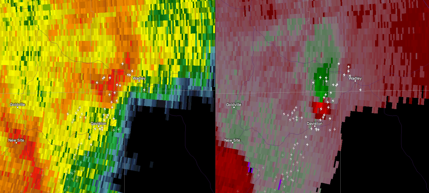
If you are in the path of this cell, go to your place of safety immediately. Radar continues to show strong circulation heading directly towards Daviston and Wadley.
Severe Weather Statement
National Weather Service Birmingham AL
348 PM CDT THU JUN 22 2017
ALC123-222130-
/O.CON.KBMX.TO.W.0042.000000T0000Z-170622T2130Z/
Tallapoosa AL-
348 PM CDT THU JUN 22 2017
…A TORNADO WARNING REMAINS IN EFFECT UNTIL 430 PM CDT FOR
NORTHEASTERN TALLAPOOSA COUNTY…
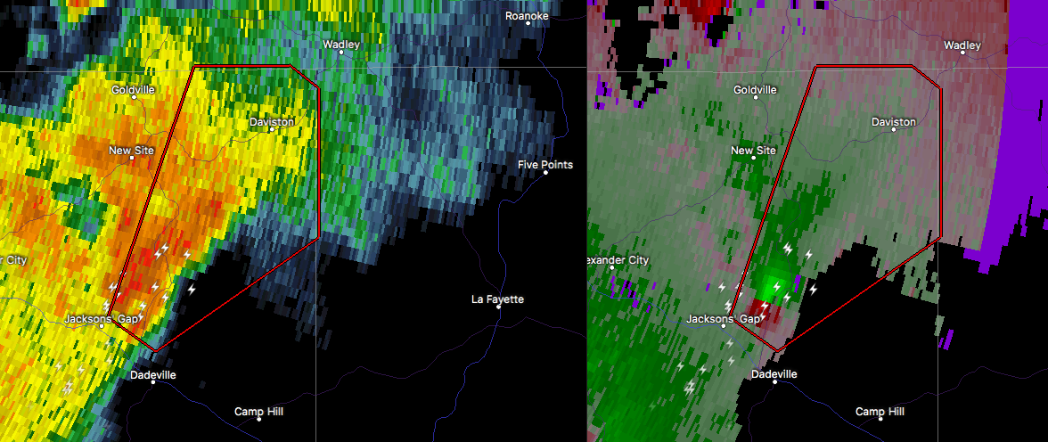
At 348 PM CDT, a severe thunderstorm capable of producing a tornado
was located over Jacksons’ Gap, or near Dadeville, moving northeast
at 30 mph.
HAZARD…Tornado.
SOURCE…Radar indicated rotation.
IMPACT…Flying debris will be dangerous to those caught without
shelter. Mobile homes will be damaged or destroyed. Damage
to roofs, windows, and vehicles will occur. Tree damage is
likely.
Locations impacted include…
Jacksons’ Gap, New Site, Daviston, Horseshoe Bend, Horseshoe Bend
National Military Park and Eagle Creek.
PRECAUTIONARY/PREPAREDNESS ACTIONS…
TAKE COVER NOW! Move to a basement or an interior room on the lowest
floor of a sturdy building. Avoid windows. If you are outdoors, in a
mobile home, or in a vehicle, move to the closest substantial shelter
and protect yourself from flying debris.
___________________________________
BULLETIN – EAS ACTIVATION REQUESTED
Tornado Warning
National Weather Service Birmingham AL
338 PM CDT THU JUN 22 2017
The National Weather Service in Birmingham has issued a
* Tornado Warning for…
Northeastern Tallapoosa County in east central Alabama…
* Until 430 PM CDT
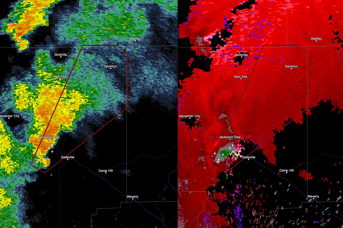
* At 338 PM CDT, a severe thunderstorm capable of producing a tornado
was located over Jacksons’ Gap, or over Dadeville, moving northeast
at 40 mph.
HAZARD…Tornado.
SOURCE…Radar indicated rotation.
IMPACT…Flying debris will be dangerous to those caught without
shelter. Mobile homes will be damaged or destroyed.
Damage to roofs, windows, and vehicles will occur. Tree
damage is likely.
* Locations impacted include…
Dadeville, Jacksons’ Gap, New Site, Jacksons Gap, Daviston, Dare
Park, Eagle Creek, Horseshoe Bend and Horseshoe Bend National
Military Park.
PRECAUTIONARY/PREPAREDNESS ACTIONS…
TAKE COVER NOW! Move to a basement or an interior room on the lowest
floor of a sturdy building. Avoid windows. If you are outdoors, in a
mobile home, or in a vehicle, move to the closest substantial shelter
and protect yourself from flying debris.
Category: Archived Warnings
About the Author (Author Profile)
Scott Martin is an operational meteorologist, professional graphic artist, musician, husband, and father. Not only is Scott a member of the National Weather Association, but he is also the Central Alabama Chapter of the NWA president. Scott is also the co-founder of Racecast Weather, which provides forecasts for many racing series across the USA. He also supplies forecasts for the BassMaster Elite Series events including the BassMaster Classic.Subscribe
If you enjoyed this article, subscribe to receive more just like it.


