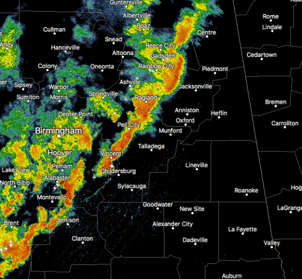
Strong Storms Affecting Even More Counties In East-Central Alabama
Strong storms are moving into the eastern parts of Central Alabama, and are putting down some impressive rainfall. Please stay weather aware as these storms can produce gusty winds that could knock down some trees with the saturated ground. Also, a brief spin-up tornado is possible.
Special Weather Statement
National Weather Service Birmingham AL
350 PM CDT FRI JUN 23 2017
ALZ018>021-025>028-232145-
Calhoun-Etowah-Clay-Shelby-Talladega-St. Clair-Cleburne-Cherokee-
350 PM CDT FRI JUN 23 2017
…A LINE OF STRONG THUNDERSTORMS WILL AFFECT TALLADEGA…CALHOUN…
EAST CENTRAL SHELBY…EASTERN ETOWAH…SOUTHEASTERN ST. CLAIR…
CENTRAL CLEBURNE…CHEROKEE AND NORTHWESTERN CLAY COUNTIES…
At 350 PM CDT, radar indicated strong thunderstorms were located
along a line extending from Cherokee Rock Village to near Ohatchee to
Wilsonville. Movement was northeast at 35 mph.
Winds in excess of 40 mph are possible with these storms.
Locations impacted include…
Gadsden, Anniston, Oxford, Talladega, Sylacauga, Pell City,
Jacksonville, Rainbow City, Childersburg, Piedmont, Hokes Bluff,
Columbiana, Centre, Heflin, Wilsonville, Cedar Bluff, Cobb Town, Fort
McClellan, Saks and Little River Canyon National Preserve.
Torrential rainfall is also occurring with these storms, and may
cause localized flooding. Do not drive your vehicle through flooded
roadways.
Category: Archived Warnings


