On This Date in 1957: A Tragedy Unfolds
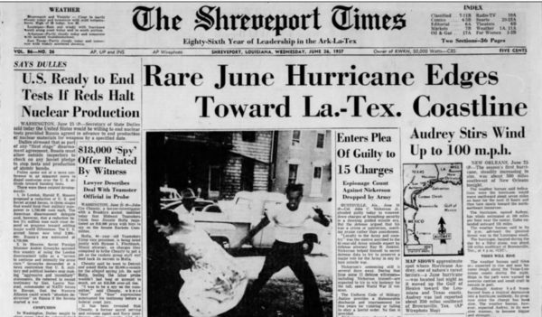
On the evening of June 26, 1957, residents of southwestern Louisiana were tracking a hurricane in the Gulf of Mexico. The storm had formed in the southwestern Gulf of Mexico two nights before. It had been classified as a tropical depression on the basis of weather reports from the Mexican coast and shrimpers in the Gulf on the evening of the 24th. When a Navy reconnaissance flight investigated the storm the next morning, they found it was already a hurricane and it was named Audrey.
Residents in Cameron Parish were surprised to see a sight they had never seen on the 26th. Thousands of crawfish were fleeing the marshes and were being squashed by automobile tires on the roads. People stopped to gather them by the thousands, filling every available container. They were planning a colossal crawfish boil as soon as Hurricane Audrey passed. The crawfish knew something was coming.
The residents did too. But they would get some bad information. All day long on the 26th, the tight knit and weather savvy Cajun community in Cameron Parish had tracked the storm carefully in radio and television reports from Lake Charles, as well as via the shortwave. The reports were ominous. But the advisories indicated the storm wouldn’t make landfall until the following afternoon. Residents packed their cars and pointed their cars out their driveways so they could hit the road early the following morning.
They listened to the 10 p.m. advisory late the evening. It said the storm was 235 miles south of Lake Charles, moving north at 10 mph, and that the center would cross the coast late the following day. Radio and television announcers frmo Lake Charles told folks to rest easy for the night.
NEW ORLEANS WEATHER BUREAU
HURRICANE WARNING AND ADVISORY NUMBER 7 AUDREY
10 PM CST JUNE 26 1957
CHANGE TO HURRICANE WARNINGS 10 PM CST ON UPPER TEXAS COAST AS FAR SOUTH AS HIGH ISLAND. LOWER STORM WARNINGS EAST OF LOUISIANA TO PENSACOLA>
AT 10 PM CST…0400Z…HURRICANE AUDREY WAS CENTERED ABOUT 235 MILES SOUTH OF LAKE CHARLES LOUISIANA NEAR LATITUDE 27.0 LONGITUDE 93.5 MOVING NORTHWARD ABOUT 10 MPH. THIS MOVEMENT IS EXPECTED TO CONTINUE AND THE AREA FROM HIGH ISLAND TO MORGAN CITY IS EXPECTED TO BEAR THE BRUNT OF THIS HURRICANE THURSDAY.
HIGHEST WINDS ARE ESTIMATED 100 MPH NEAR CENTER AND GALES EXTEND OUT 150 TO 200 MILES TO EAST AND NORTH OF CENTER AND 50 MILES TO THE SOUTHWEST.
TIDES ARE EXPECTED TO REACH 5 TO 9 FFET FROM HIGH ISLAND TEXAS TO MORGAN CITY LOUISIANA AND 3 TO 6 FEET ELSEWHERE FROM FREEPORT TEXAS TO BILOXI MISSISSIPPI BY LATE THURSDAY. ALL PERSONS IN LOW EXPOSED PLACES SHOULD MOVE TO HIGHER GROUND. WINDS ARE INCREASING ALONG THE UPPER TEXAS AND LOUISIANA COASTS AND WILL REACH GALE FORCE TONIGHT AND EARLY THURSDAY.
HURRICANE WARNINGS ARE DISPLAYED ALONG THE ENTIRE LOUISIANA COAST AND ON THE UPPER TEXAS COAST AS FAR SOUTH AS HIGH ISLAND AND STORM WARNINGS AT GALVESTON. THE THREAT OF HURRICANE FORCE WINDS OVER SOUTHEAST LOUISIANA HAS LESSENED CONSIDERABLY.
NEXT ADVISORY AT 4 AM CST BULLETIN AT 1 AM CST.
CONNER WEATHER BUREAU NEW ORLEANS
Unfortunately, the hurricane strengthened rapidly just before landfall on the Gulf Coast near the remote fishing village of Cameron LA on the Texas/Louisiana border during the early morning hours. It also began moving faster. The storm’s central pressure dropped from 973 to 945 millibars (and perhaps even lower) in just 5 hours. Winds reached 150 mph. The rapid intensification generated a storm surge of at least 12 feet above normal which was not anticipated.
At 1:30 a.m., forecasters at the Weather Bureau in Lake Charles noted with alarm that the storm was moving faster (15-20 mph) and that escape routes would be cut off earlier. But many broadcast outlets were off the air and folks had gone to bed anyway.
NEW ORLEANS WEATHER BUREAU BULLETIN
1 AM CST JUNE 26 1957
HURRICANE AUDREY HAS INCREASED ITS FORWARD SPEED AND IS MOVING NORTHWARD ABOUT 15 MPH.
AT 1 AM CST IT WAS CENTERED ABOUT 150 MILES SOUTH FO THE PORT ARTHUR LAKE CHARLES AREA. IT IS EXPECTED TO REACH THE COAST NEAR THE TEXAS LOUISIANA LINE WITH WINDS UP TO 100 MPH IN THE LAKE CHARLES PORT ARTHUR AREA BEFORE NOON TODAY.
WINDS AND TIDES ARE RISING ALONG THE UPPER TEAS AND LOUISIANA COASTS.
TIDES 5 TO 9 FEET ARE EXPECTED FROM HIGH ISLAND TEXAS TO MORGAN CITY LOUISIANA AND 3 TO 6 FEET ELSEWHERE FROM FREEPORT TEXAS TO BILOXI MISSISSIPPI TODAY.
HURRICANE WARNINGS REMAIN IN DISPLAYED ALONG THE ENTIRE LOUISIANA COAST AND THE UPPER TEXAS COAST AS FAR SOUTH AS HIGH ISLAND. STORM WARNINGS AT GALVESTON. WINDS ALONG THE SOUTHEAST LOUISIANA COAST WONT REACH HURRICANE FORCE BUT ROUGH SEAS AND HIGH TIDES WARRANT THE WARNING.
KRAFT WEATHER BUREAU NEW ORLEANS
Many of those ready to evacuate awakened to the sound of water rushing around their homes. Around 1,000 made it to the Courthouse in Cameron. The three story structure survived the storm, despite a surge that came nearly to the second floor with waves that battered the building.

390 people died in Louisiana (127 of them unidentified) with another 192 were reported missing. The loss of life was the greatest in the United States since the 1938 Hurricane in New England. Areas as far as 25 miles inland were inundated by the storm tides. As much as percent of the homes in the area from Cameron to Grand Cheniere, Louisiana were destroyed or floated off their foundations. A cement block icehouse was the only other structures standing in Cameron after the hurricane beside the Courthouse.

Citizens brought several wrongful death lawsuits against the U.S. Weather Bureau for not warning them properly. But a jury found for the defendant under the Federal Tort Claims Act, and the lawsuit was unsuccessful.
I had a wonderful talk back in 2012 with author Cathy Post about Hurricane Audrey. Her outstanding book is the definitive account of the storm.
Go back and listen to the this WeatherBrains show from 2012night. We spoke with Jimmy and Keith Trahan, two survivors of the hurricane.
Category: ALL POSTS, Met 101/Weather History
About the Author (Author Profile)
Bill Murray is the President of The Weather Factory. He is the site's official weather historian and a weekend forecaster. He also anchors the site's severe weather coverage. Bill Murray is the proud holder of National Weather Association Digital Seal #0001 @wxhistorianSubscribe
If you enjoyed this article, subscribe to receive more just like it.


