

Pretty Steamy Out There With Strong Storms Moving In At Midday

RADAR CHECK AT 1:10PM
For most of Central Alabama, the radar is currently clear… but we do have some pretty hefty thunderstorms moving into the western counties of Central Alabama from the neighboring state of Mississippi. A nice-sized thunderstorm is currently affecting the northern part of Lamar and the central parts of Marion counties. A strong thunderstorm was over Beaverton, or 8 miles east of Sulligent, and was moving east at 25 MPH. Winds of 40 to 50 MPH will be possible with this storm, and locations in the path are Winfield, Guin, Brilliant, Glen Allen, Gu-Win, Twin and Tucker. Pretty much the rest of the area is dry, and there is a mix of clouds and sun.

We do note that the northwestern corner of the state has been defined in a Marginal Risk for severe storms throughout the remainder of the day today, with the main risk coming from damaging downburst thunderstorm winds.
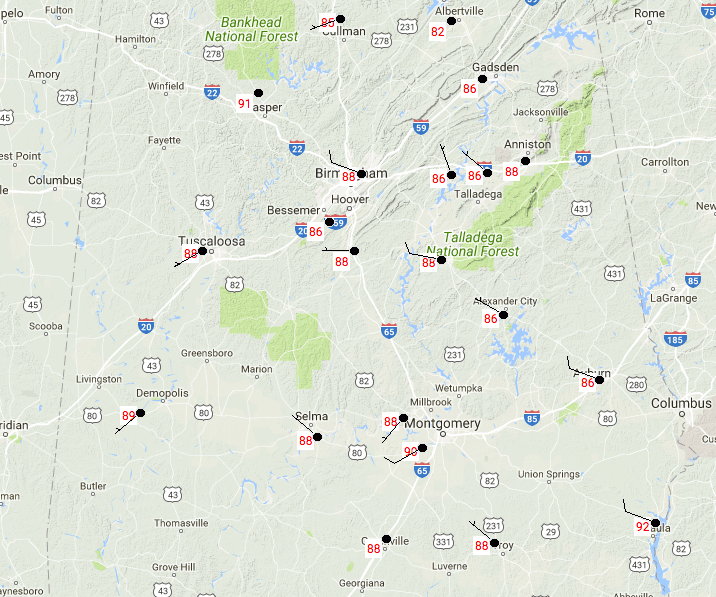
TEMPERATURES ACROSS CENTRAL ALABAMA
It’s a hot one on this Independence Day Eve, with current temperatures in the mid 80s tot he lower 90s throughout the area. The warm spot is currently Eufaula at 92 degrees, with the cool spot of Cullman not too far behind at 85 degrees.
REST OF TODAY AND TONIGHT
Most, if not all, of the afternoon convective shower and thunderstorm activity will stay roughly north of the I-20 corridor, especially the storms that are moving in from Mississippi at this point. Otherwise, skies will be partly to mostly cloudy as the day progresses, and afternoon highs making up into the upper 80s to the lower 90s. For tonight, showers chances will be on the decrease, but the best chances for those will remain in the northern half of the area. Lows will be in the lower 70s.
INDEPENDENCE DAY
Another typical summertime forecast for Central Alabama… a mix of sun and clouds, with the usual risk of mainly scattered afternoon showers and thunderstorms, with the better chances of those in the northern half of the area. A few could fire up during the morning, and some could even linger into the evening. I do believe all will have dissipated by the time the big fireworks show is ready to start at Vulcan. Highs will once again be in the upper 80s to the lower 90s, with lows in the lower 70s.
EYE ON THE TROPICS
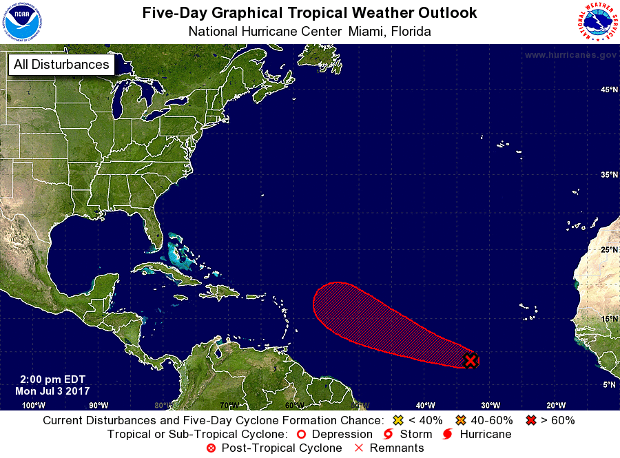
We have an active wave out over the open waters of the eastern Atlantic Ocean that has a 70% chance of becoming an organized tropical system. It is stationary as of now, but is forecast to start moving to the west-northwest in a day or so. Models have this one potentially getting close to the Atlantic Coast within the next 10 days, so we will keep our eyes on it.
HEADING TO THE BEACH
For a detailed look at the weather from Fort Morgan over to Panama City Beach, click here to see the AlabamaWx Beach Forecast Center page. The Beach Forecast is partially underwritten by the support of Brett/Robinson Vacation Rentals in Gulf Shores and Orange Beach. Click here to see Brett/Robinson’s Own Your Summer specials now!
TODAY IN WEATHER HISTORY
July 3, 1987 – Lightning struck and killed three men playing golf on a course near Kingsport TN. The three men had sought shelter from the rain under a tall tree on a small hill. Showers and thunderstorms produced heavy rain in New Jersey, with 5.2 inches reported at Trenton State College.
WEATHERBRAINS
Don’t forget you can listen to our weekly 90 minute netcast anytime on the web, or on iTunes. This is the show all about weather featuring many familiar voices, including our meteorologists here at ABC 33/40. you can watch it live here on Monday nights at 8:30PM CDT.
Category: Alabama's Weather, ALL POSTS
About the Author (Author Profile)
Scott Martin is an operational meteorologist, professional graphic artist, musician, husband, and father. Not only is Scott a member of the National Weather Association, but he is also the Central Alabama Chapter of the NWA president. Scott is also the co-founder of Racecast Weather, which provides forecasts for many racing series across the USA. He also supplies forecasts for the BassMaster Elite Series events including the BassMaster Classic.Subscribe
If you enjoyed this article, subscribe to receive more just like it.


