Isolated Showers Again Today
Central Alabama is starting out shower free this morning, but a large cluster of thunderstorms which prompted flash flood warnings for the eastern portion of the Tennessee River Valley was moving across that area into Northwest Georgia. Temperatures were starting the day in the lower 70s for much of Central Alabama. Much like we saw yesterday, it looks like the primary focus for showers and storms will be across the Tennessee River Valley. Slightly drier air has worked its way into Central and South Alabama, so any showers that do form should be in the heat of the afternoon and fairly isolated. Probably the unknown factor will be how much of a role the boundary laid down by the early morning storms will play in convective development later today. Highs across Central Alabama should be mainly in the lower 90s though across South Alabama heat indices may reach the 100 to 102 range.
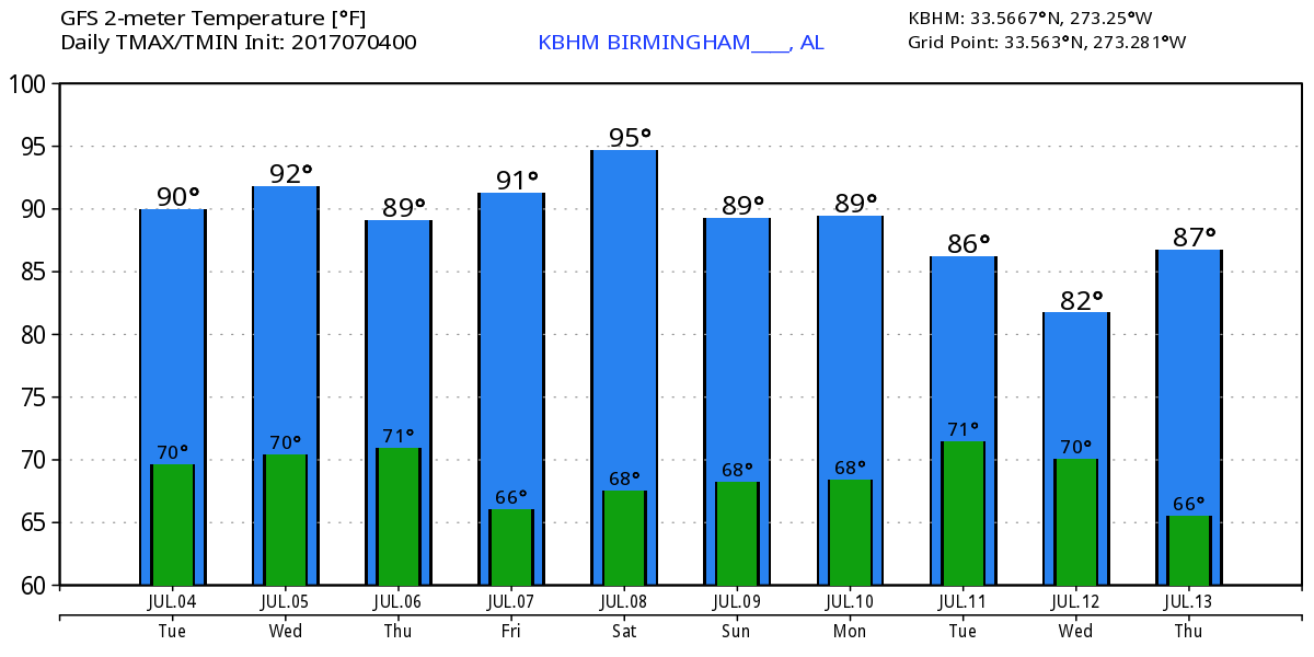
The overall upper air pattern remains one of an upper trough over the eastern half of the country and an upper ridge in the western part of the US. A fairly strong short wave located over Northeast Oklahoma this morning will move into the Middle Mississippi River Valley on Wednesday and the Ohio Valley on Thursday. At the surface a weak surface low will track from Southeast Missouri to Ohio by Thursday with a weak frontal zone trailing southwestward into northern Louisiana. This frontal zone should be the focus for more numerous showers and thunderstorms on Thursday. Our afternoon highs will be in the range of 89 to 92 for these days.
With the support of a building ridge in the western US, the troughiness over the eastern US should be enough to force the frontal zone well into southern Alabama by Saturday. The GFS does not, however, really dry out our air mass, so we’ll probably have to maintain small chances of rain driven primarily by afternoon heating through the weekend.
There is very little change to the overall upper air pattern into the first of next week, so the forecast is likely to remain pretty monotonous with daily chances for showers and thunderstorms. Fortunately, with the troughiness holding in the eastern part of the country, we should remain out of any excessive heat with highs mainly in the range of 89 to 93. That may not stay that way as we look out into voodoo country.
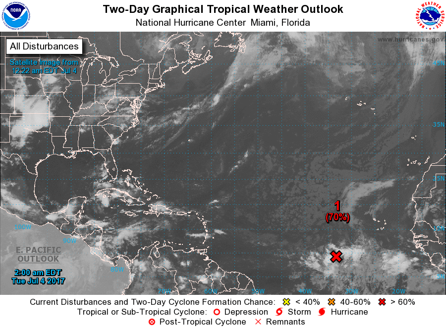
Tropical Atlantic has one area of concern about 750 miles southwest of the Cabo Verde Islands. This area of disturbed weather has become slightly better organized in the last 24 hours and conditions appear favorable for additional slow development as the system moves west and then west-northwest over the next several days. A depression or tropical storm may form during the next 72 hours, and if so, it would be named Don.
The weather at the beach will include the possibility of a passing shower just about everyday for the next week with highs in the upper 80s. There is no indication of any all day rain situation, so you should be able to enjoy the beach with only short interruptions for a passing shower. Please heed those showers and don’t become a lightning statistic. Rip current threat is low for the next couple of days. Click here to see the AlabamaWx Beach Forecast Center page. The Beach Forecast is partially underwritten by the support of Brett/Robinson Vacation Rentals in Gulf Shores and Orange Beach. Click here to see Brett/Robinson’s Own Your Summer specials now!
Looking into voodoo country, the GFS has come back around to the idea of the huge upper ridge building into the eastern US. The 594 height contour builds into the Middle Mississippi River Valley around the 13th of July and holds there for a couple of days until the 15th. Between the 15th and the 19th, the ridge builds into the eastern Great Lakes area with a ridge encompassing nearly all of the Lower 48 States. This would certainly point to the potential for some excessive heat in the 17th to 19th time frame.
I’ll be filling in for James Spann later today with the latest forecast at 4, 5, 6, and 10 pm on ABC 3340, so be sure to tune in for the up-to-date weather picture. Have a great day, Happy 4th of July, and Godspeed.
-Brian-
Category: Alabama's Weather, ALL POSTS
About the Author (Author Profile)
Brian Peters is one of the television meteorologists at ABC3340 in Birmingham and a retired NWS Warning Coordination Meteorologist. He handles the weekend Weather Xtreme Videos and forecast discussion and is the Webmaster for the popular WeatherBrains podcast.Subscribe
If you enjoyed this article, subscribe to receive more just like it.


