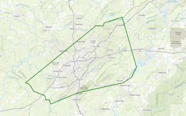
Urban & Small Stream Flood Advisory for Parts of Jefferson, Shelby & St. Clair Counties Until 8PM
Flood Advisory
National Weather Service Birmingham AL
502 PM CDT WED JUL 5 2017
ALC073-115-117-060100-
/O.NEW.KBMX.FA.Y.0075.170705T2202Z-170706T0100Z/
/00000.N.ER.000000T0000Z.000000T0000Z.000000T0000Z.OO/
Shelby AL-Jefferson AL-St. Clair AL-
502 PM CDT WED JUL 5 2017
The National Weather Service in Birmingham has issued a
* Urban and Small Stream Flood Advisory for…
Northern Shelby County in Alabama…
Central Jefferson County in Alabama…
Southwestern St. Clair County in Alabama…
* Until 800 PM CDT
* At 501 PM CDT, Doppler radar indicated heavy rain due to
thunderstorms. This will cause urban and small stream flooding in
the advisory area.
* Some locations that may experience flooding include…
Birmingham, Hoover, Vestavia Hills, Bessemer, Homewood, Pelham,
Mountain Brook, Trussville, Helena, Hueytown, Gardendale,
Irondale, Leeds, Moody, Fairfield, Chelsea, Fultondale,
Springville, and Odenville.
PRECAUTIONARY/PREPAREDNESS ACTIONS…
Turn around, don’t drown when encountering flooded roads. Most flood
deaths occur in vehicles.


