Uptick in Showers/Storms
Starting the day out with a few clouds across the Tennessee River Valley along with some patchy fog and a few showers all thanks to the continuation of a weak frontal boundary that has remained in place for the last several days. It appears that this boundary will slide a little south later today, primarily this evening, potentially increasing the areal coverage of showers and storms for Central Alabama. I expect to see highs once again reach the lower 90s unless your location happens to come under the influence of one of the showers or storms.
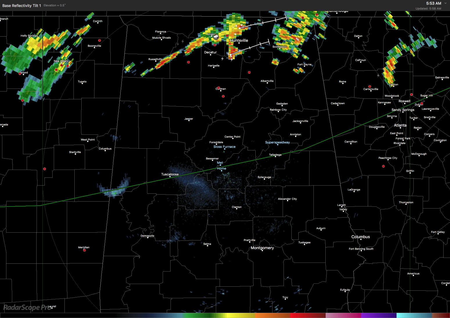
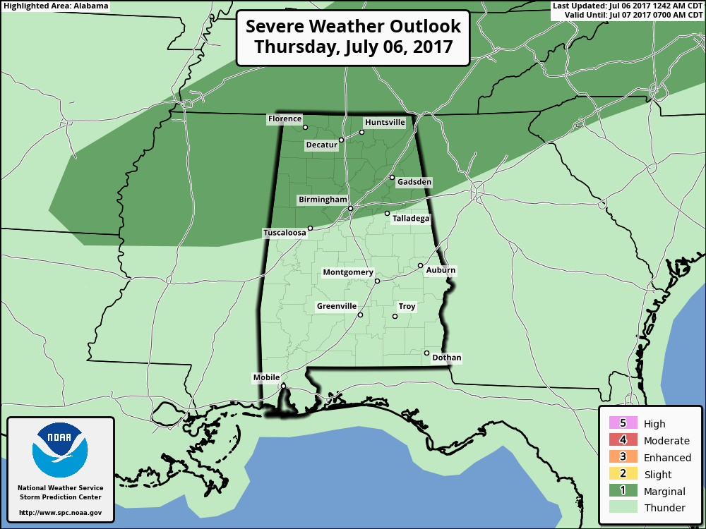
SPC has a marginal risk for severe storms for the northern third of Alabama generally along and north of a line from Tuscaloosa to Talladega. Much like we saw yesterday, storms that go severe will be isolated and will produce damaging straight line wind. And, like we saw yesterday, warnings for these events will be hard to issue to catch the short-lived downbursts that occur.
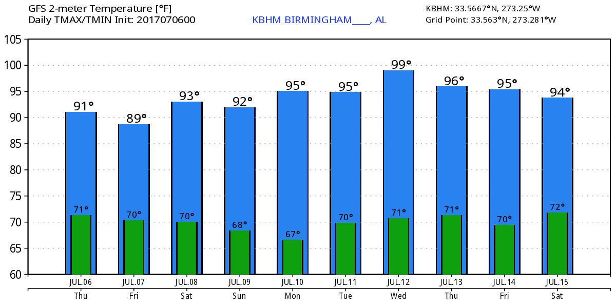
The good news for us and much of the eastern half of the country is that the upper air pattern will continue with the ridge in the west and the trough in the east. The trough will remain in place fairly much unchanged trough the first of next week. Monday we begin to see signs of the trough pulling northward somewhat allowing the western US ridge to push into the Middle Mississippi River Valley from Tuesday through Thursday. This could lead to slightly warmer temperatures for Central Alabama with highs in the lower 90s over the weekend and into Monday with lower to middle 90s toward the middle of next week. But the GFS continued with the notion of keeping the main axis of the ridge well to our west though the position by Thursday will lead to some hot weather in the Central US.
With the trough remaining in place, the weak frontal boundary should push into South Alabama by Saturday allowing the focus of showers and storms to move closer to the coast. But we will stay with a daily threat of storms from diurnal heating as coverage remains in the 20 to 40 percent range.
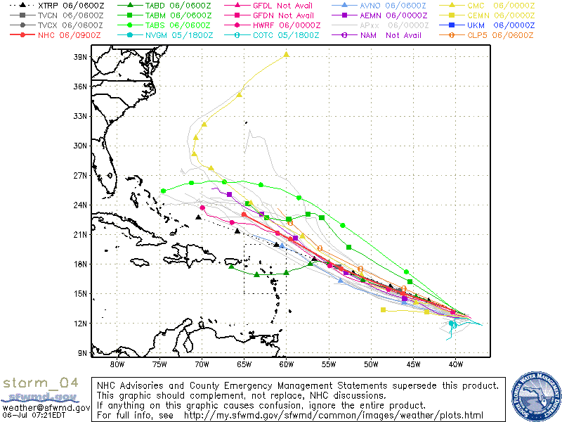
The tropics remain somewhat active. Tropical Depression 4 came to life yesterday afternoon, but it is currently forecast to remain a depression as it moves northwestward north of the Leeward Islands. It is likely to dissipate by next Monday as it enters a less favorable environment for the tropical depression. In the eastern North Pacific, there remain two areas of disturbed weather neither of which poses any threat to land.
The weather at the beach will include the possibility of a passing shower just about everyday for the next 7 days with highs in the upper 80s. There is no indication of any all day rain situation, so you should be able to enjoy the beach with only short interruptions for a passing shower. Please heed those showers and don’t become a lightning statistic. Rip current threat is low for the next couple of days. Click here to see the AlabamaWx Beach Forecast Center page. The Beach Forecast is partially underwritten by the support of Brett/Robinson Vacation Rentals in Gulf Shores and Orange Beach. Click here to see Brett/Robinson’s Own Your Summer specials now!
Looking into voodoo country, the GFS is sticking with the idea of keeping the ridge in the western US. A couple of reasonably strong short waves help to reinforce the troughiness over the eastern US from July 15th through the 18th. By the end of the extended period, the GFS has an interesting pattern with a closed upper low over the Lower Mississippi River Valley. This pattern would result in a rather wet pattern over the Southeast US if it comes to be. So the big takeaway from the GFS projections is that we stay out of the excessive heat but the western US stays in the broiler!
I expect to have the next Weather Xtreme Video posted here by 7 am or so on Friday morning. I hope that you have a great day and Godspeed.
-Brian-
Category: Alabama's Weather, ALL POSTS
About the Author (Author Profile)
Brian Peters is one of the television meteorologists at ABC3340 in Birmingham and a retired NWS Warning Coordination Meteorologist. He handles the weekend Weather Xtreme Videos and forecast discussion and is the Webmaster for the popular WeatherBrains podcast.Subscribe
If you enjoyed this article, subscribe to receive more just like it.


