Severe Thunderstorm Warning Continues For Parts Of Jackson And Madison Counties Until 2:45PM

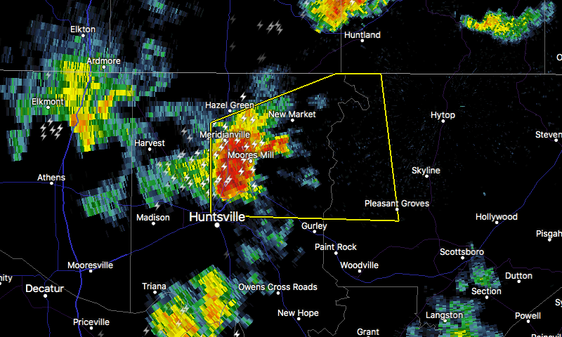
…A SEVERE THUNDERSTORM WARNING REMAINS IN EFFECT UNTIL 245 PM CDT FOR NORTHWESTERN JACKSON AND NORTHEASTERN MADISON COUNTIES… At 231 PM CDT, a severe thunderstorm was located near Moores Mill, moving east at 30 mph.
HAZARD…60 mph wind gusts.
SOURCE…Radar indicated.
IMPACT…Expect damage to roofs, siding, and trees. Locations impacted include… Northern Huntsville, Moores Mill, Meridianville, Hazel Green, New Market, Alabama A And M University, Pleasant Groves, Francisco, Ryland and Maysville.
Severe Thunderstorm Warning Issued For Parts Of Jackson And Madison Counties Until 2:45PM
Jul 6th @ 2:22 pm

The National Weather Service in Huntsville Alabama has issued a
* Severe Thunderstorm Warning for…
Northwestern Jackson County in northeastern Alabama…
Northeastern Madison County in north central Alabama…
* Until 245 PM CDT
* At 221 PM CDT, a severe thunderstorm was located over Moores Mill, moving east at 30 mph.
HAZARD…60 mph wind gusts.
SOURCE…Radar indicated.
IMPACT…Expect damage to roofs, siding, and trees.
* Locations impacted include…
Northern Huntsville, Moores Mill, Meridianville, Hazel Green, Gurley, Alabama A And M University, New Market, Pleasant Groves, Francisco and Ryland.
Category: ALL POSTS, Archived Warnings
About the Author (Author Profile)
Subscribe
If you enjoyed this article, subscribe to receive more just like it.


