

Severe Thunderstorm Warning Canceled For Parts Of Walker County
…THE SEVERE THUNDERSTORM WARNING FOR SOUTHEASTERN WALKER COUNTY IS CANCELLED… The storms which prompted the warning have weakened below severe limits, and no longer pose an immediate threat to life or property. Therefore the warning has been cancelled.
Severe Thunderstorm Warning Continues For Parts Of Walker County Until 6:45PM
Jul 6th @ 6:00 pm

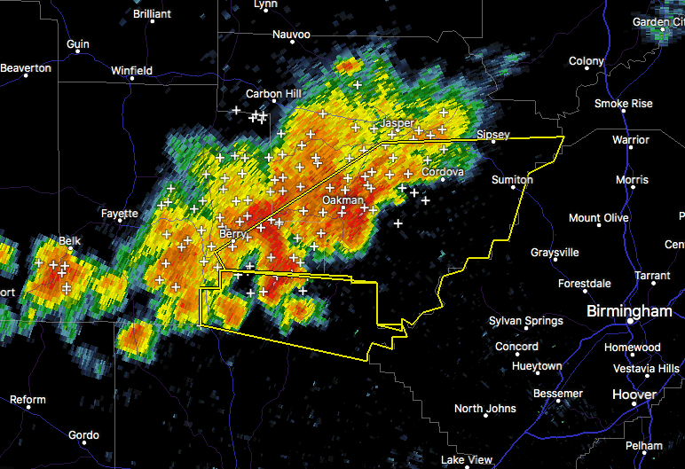
…A SEVERE THUNDERSTORM WARNING REMAINS IN EFFECT UNTIL 645 PM CDT FOR SOUTHEASTERN WALKER COUNTY… At 620 PM CDT, severe thunderstorms were located along a line extending from Cordova to near Gorgas Steam Plant to 7 miles southeast of Boley Springs, moving east at 20 mph.
HAZARD…60 mph wind gusts.
SOURCE…Radar indicated.
IMPACT…Expect damage to roofs, siding, and trees. Locations impacted include… Quinton, Gorgas Steam Plant, Gorgas, Goodsprings, Barney, The Wye and Tutwiler.
Severe Thunderstorm Warning Canceled For Parts Of Fayette County
Jul 6th @ 6:00 pm
…THE SEVERE THUNDERSTORM WARNING FOR SOUTHEASTERN FAYETTE COUNTY IS CANCELLED… The storms which prompted the warning have moved out of the warned area. Therefore, the warning has been cancelled.
Severe Thunderstorm Warning Continues For Parts Of Fayette And Walker Counties Until 6:45PM
Jul 6th @ 6:00 pm

…A SEVERE THUNDERSTORM WARNING REMAINS IN EFFECT UNTIL 645 PM CDT FOR SOUTHEASTERN WALKER AND SOUTHEASTERN FAYETTE COUNTIES… At 611 PM CDT, severe thunderstorms were located along a line extending from near Cordova to near Gorgas to 6 miles southeast of Boley Springs, moving southeast at 25 mph.
HAZARD…60 mph wind gusts.
SOURCE…Radar indicated.
IMPACT…Expect damage to roofs, siding, and trees. Locations impacted include… Dora, Parrish, Oakman, Quinton, Boley Springs, Gorgas Steam Plant, Gorgas, Goodsprings, Barney, The Wye and Tutwiler.
Severe Thunderstorm Warning Issued For Parts Of Fayette And Walker Counties Until 6:45PM
Jul 6th @ 6:00 pm

The National Weather Service in Birmingham has issued a
* Severe Thunderstorm Warning for…
Central Walker County in Alabama…
Southeastern Fayette County in west central Alabama…
* Until 645 PM CDT
* At 600 PM CDT, severe thunderstorms were located along a line extending from near Jasper to near Oakman to 7 miles east of
Ashcraft Corner, moving east at 20 mph.
HAZARD…60 mph wind gusts.
SOURCE…Radar indicated.
IMPACT…Expect damage to roofs, siding, and trees.
* Locations impacted include…
Jasper, Sumiton, Cordova, Dora, Berry, Parrish, Oakman, Sipsey, Boley Springs, Gorgas Steam Plant, Rocky Hollow, Burnwell, Beloit, Quinton, Gorgas, Lynns Park, Goodsprings, Barney, Empire and West
Corona.
Category: ALL POSTS, Archived Warnings
About the Author (Author Profile)
Subscribe
If you enjoyed this article, subscribe to receive more just like it.


