

Two Dry Days for a Change
You don’t often get to use the dramatic title in the summer months in the Southeast US. But several things appear different for us this morning in Central Alabama. The first noteworthy item is that clouds are across the southern half of the state. Second, while dew points remain in the lower 70s in Central Alabama, dew points are in the 60s across the Tennessee River Valley, and that drier air should be advecting into our region. This means that we should be seeing a good deal of sunshine today along with an absence of showers for North and Central Alabama. Scattered showers are still likely across South Alabama and Northwest Florida.

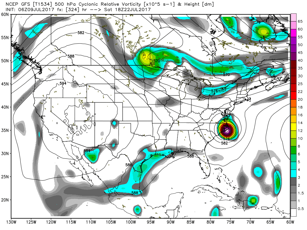
The tropical Atlantic is quiet this morning. An area of cloudiness which was Tropical Depression Four is visible just northeast of the Virgin Islands, and a new wave appears to be coming off the African continent. That wave is an important item to note because the GFS is developing something in the tropics in about a week, so that wave will bear watching. In the eastern North Pacific, we have the first Category 2 hurricane of the 2017 Northern Hemisphere tropical season. Eugene is forecast to remain at sea as it treks northwestward off the Mexican coast.
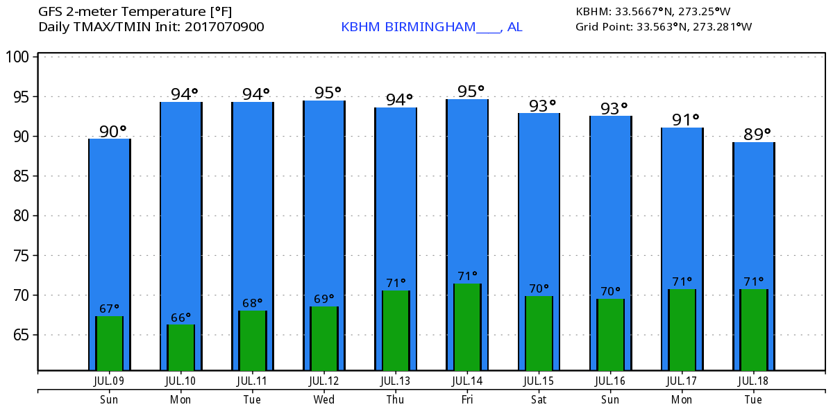
Monday the troughiness over the eastern US begins to wane as the upper ridge to the west pushes into the Middle Mississippi River Valley. By Tuesday and Wednesday the ridge covers the entire southern tier of the US from coast to coast. Moisture values will also return as dew points climb into the lower 70s once again by Wednesday. This means showers will return to the forecast as we stay in a pattern favoring daily showers driven by the afternoon heating. Much like I noted yesterday, I expect to see some of the highest thickness values around the Thursday time frame, but the GFS MOS guidance table is still projecting highs to be only in the lower 90s. I think we will see at least the middle 90s in the Wednesday-Thursday time frame with upper 90s a possibility.
Thursday a strong trough coming across southern Canada is forecast to begin digging into the eastern US and continue digging the trough into the weekend. This should also bring a cold front into the Ohio River Valley by Sunday, so we could be seeing better forcing besides the daily heat of the afternoon. For now it looks like we just continue into the weekend with scattered showers. With the trough digging into the eastern US, temperatures should settle back into the lower 90s.

The weather at the beach remains unchanged with the possibility of passing showers just about everyday for the next 7 days with highs in the upper 80s. There is no indication of any all day rain situation, so you should be able to enjoy the beach with only short interruptions for a passing shower. Please heed those showers and don’t become a lightning statistic. Rip current threat is low for the next couple of days. Click here to see the AlabamaWx Beach Forecast Center page. The Beach Forecast is partially underwritten by the support of Brett/Robinson Vacation Rentals in Gulf Shores and Orange Beach. Click here to see Brett/Robinson’s Own Your Summer specials now!
Looking out into voodoo country, the GFS maintain the development of a tropical weather system in the Caribbean around the 16th of July. Over the continental US, the pattern of an upper ridge in the West and a trough in the East is maintained through the entire Week 2, so the big takeaway here is that we should not be seeing any excessive heat. As to the tropical system, it is interesting to note that the GFS has been consistent in identifying this system for the last two days even though locations vary. With the wave coming off Africa, there could be some validity to this projected development, so we’ll need to keep an eye on it.
It has been a pleasure providing the Weather Xtreme Videos for the last week while James Spann was able to enjoy a little time off. He is forecast to be back with the next edition first thing on Monday morning. I hope that you have a great day. Enjoy the drier weather for a couple of days. Godspeed.
-Brian-
Category: Alabama's Weather, ALL POSTS
About the Author (Author Profile)
Brian Peters is one of the television meteorologists at ABC3340 in Birmingham and a retired NWS Warning Coordination Meteorologist. He handles the weekend Weather Xtreme Videos and forecast discussion and is the Webmaster for the popular WeatherBrains podcast.Subscribe
If you enjoyed this article, subscribe to receive more just like it.


