A Quick Check On Our Weather Situation At 3:25PM
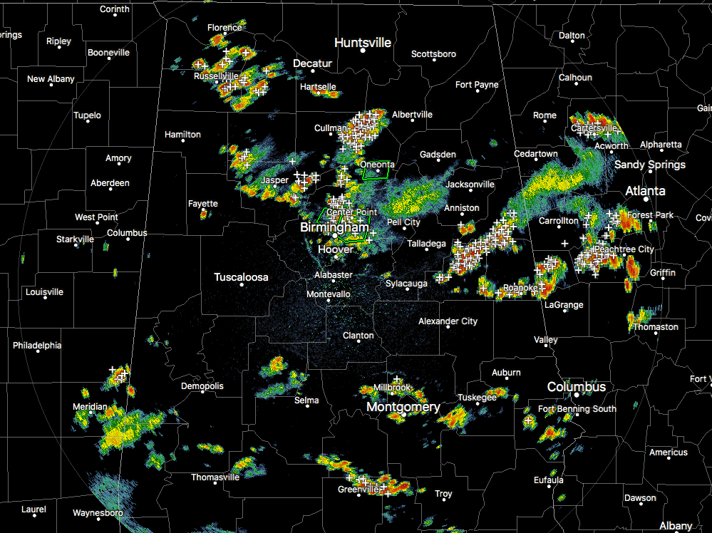
Radar Check at 3:15 PM
Numerous showers and thunderstorms are continuing to fall across portions of North and Central Alabama at this point. The larger storms on radar at this point are over portions of Clay, Randolph, and Cleburne counties, along with another storm over portions of Cullman and Blount counties. The latter storm has warranted a Significant Weather Advisory for parts of Cullman and Marshall counties until 3:45 PM.
We are continuing to have rain over parts of Jefferson County where a couple of Flash Flood Warnings are in effect. Latest local storm reports have water covering the roadway on Pinson Valley Parkway in Tarrant, along with Stouts Road in Fultondale, and Tallapoosa Street at I-20/59. A Flash Flood Warning also remains in effect for parts of Blount County as well.
An Areal Flood Warning has just been issued for parts of Clay County until 6:15 PM for thunderstorms dumping very heavy rainfall that could lead to small stream flooding. So heads up for Lineville, Ashland, Delta, and Barfield.
We still plenty of unstable air over the state at this point, with he highest levels of surface instability over the northeast corner of Central Alabama (mainly Etowah and Cherokee counties in our area, and up into Dekalb and Marshall counties in North Alabama.
Those CAPE values are in the 3500-4000 J/kg range, while much of the rest of Central Alabama are in the 2000-3000 J/kg range. Those values are coinciding with the 2-meter temperatures, as those are the warmest in the same region. Precipitable water values are in the 2.00-2.50 inch range in the same area as well. I believe this is where the next concentration of storms could fire up and put down heavy amounts of rain.
These storms are expected to continue on throughout the remainder of the afternoon and early evening hours until we lose the heating from the sunlight. The storms will begin to dissipate some, but a few could hang on throughout the late night and overnight hours.
Just remember the rules for floods and lightning… When water is covering the roadway, turn around and don’t drown… When thunder roars, go indoors. We’ll keep you updated throughout the day.
Category: Alabama's Weather, ALL POSTS
About the Author (Author Profile)
Scott Martin is an operational meteorologist, professional graphic artist, musician, husband, and father. Not only is Scott a member of the National Weather Association, but he is also the Central Alabama Chapter of the NWA president. Scott is also the co-founder of Racecast Weather, which provides forecasts for many racing series across the USA. He also supplies forecasts for the BassMaster Elite Series events including the BassMaster Classic.Subscribe
If you enjoyed this article, subscribe to receive more just like it.


