Heavy Rains Continue To Fall Over Southeastern Portions of Central Alabama
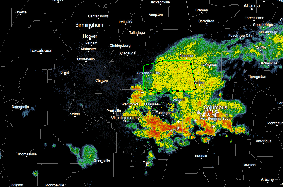
Very heavy rainfall continues to soak portions of the southeastern part of Central Alabama. We currently have a Flash Flood Warning in effect until 10:30 AM for parts of Chambers and Tallapoosa counties, and if the rainfall continues at this pace, that may need to be extended.
We also have two separate Areal Flood Advisories in effect… One is for Lee and Russell counties until 10:45 AM. This includes the cities of Auburn (including Auburn University), Phenix City, and Opelika. Looking at the latest from the NWS Chat, a Flash Flood Warning may be issued for this area soon. The second is for parts of Elmore, Bullock, Macon, Montgomery, and Coosa counties until 12:15 PM. This includes the cities of Montgomery, Tuskegee, Tallassee, Union Springs, and more.
With precipitable water values over 2.00 inches along and south of the I-20 corridor, this is where we will probably see the most rainfall activity that will have the greatest potential for flash flooding. Showers and storms are possible north of that as well, but with precipitable water values less than 2.00 inches, the risk for flooding rains is less, but not zero.
Category: Alabama's Weather, ALL POSTS
About the Author (Author Profile)
Scott Martin is an operational meteorologist, professional graphic artist, musician, husband, and father. Not only is Scott a member of the National Weather Association, but he is also the Central Alabama Chapter of the NWA president. Scott is also the co-founder of Racecast Weather, which provides forecasts for many racing series across the USA. He also supplies forecasts for the BassMaster Elite Series events including the BassMaster Classic.Subscribe
If you enjoyed this article, subscribe to receive more just like it.


