

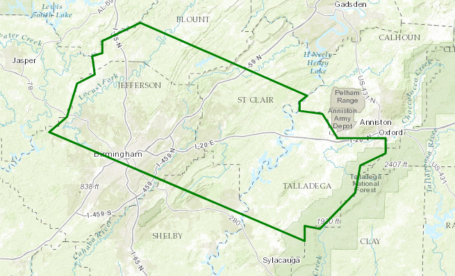
Areal Flood Advisory for Parts of Jefferson, Blount, Shelby, Talladega, & St. Clair Counties Until 12:30 AM
Flood Advisory
National Weather Service Birmingham AL
938 PM CDT THU AUG 10 2017
ALC009-073-115-117-121-110530-
/O.NEW.KBMX.FA.Y.0123.170811T0238Z-170811T0530Z/
/00000.N.ER.000000T0000Z.000000T0000Z.000000T0000Z.OO/
Talladega AL-Blount AL-Shelby AL-Jefferson AL-St. Clair AL-
938 PM CDT THU AUG 10 2017
The National Weather Service in Birmingham has issued a
* Urban and Small Stream Flood Advisory for…
Talladega County in east central Alabama…
Southwestern Blount County in central Alabama…
Northeastern Shelby County in central Alabama…
Northeastern Jefferson County in central Alabama…
St. Clair County in central Alabama…
* Until 1230 AM CDT
* At 936 PM CDT, Doppler radar indicated heavy rain due to
thunderstorms. This will cause urban and small stream flooding in
the advisory area.
* Some locations that will experience flooding include…
Birmingham, Hoover, Vestavia Hills, Oxford, Mountain Brook,
Trussville, Talladega, Gardendale, Pell City, Irondale, Leeds,
Moody, Fultondale, Oneonta, Springville, Odenville, Sumiton,
Pinson-Clay-chalkv, Dallas and Center Point.
PRECAUTIONARY/PREPAREDNESS ACTIONS…
Turn around, don’t drown when encountering flooded roads. Most flood
deaths occur in vehicles.
Be especially cautious at night when it is harder to recognize the
dangers of flooding.
Category: ALL POSTS
About the Author (Author Profile)
Scott Martin is an operational meteorologist, professional graphic artist, musician, husband, and father. Not only is Scott a member of the National Weather Association, but he is also the Central Alabama Chapter of the NWA president. Scott is also the co-founder of Racecast Weather, which provides forecasts for many racing series across the USA. He also supplies forecasts for the BassMaster Elite Series events including the BassMaster Classic.Subscribe
If you enjoyed this article, subscribe to receive more just like it.


