A Midday Look: Wet Weather Ahead For Central Alabama
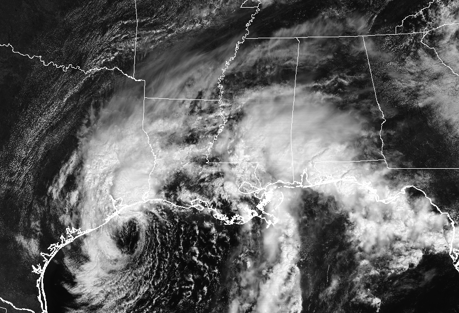
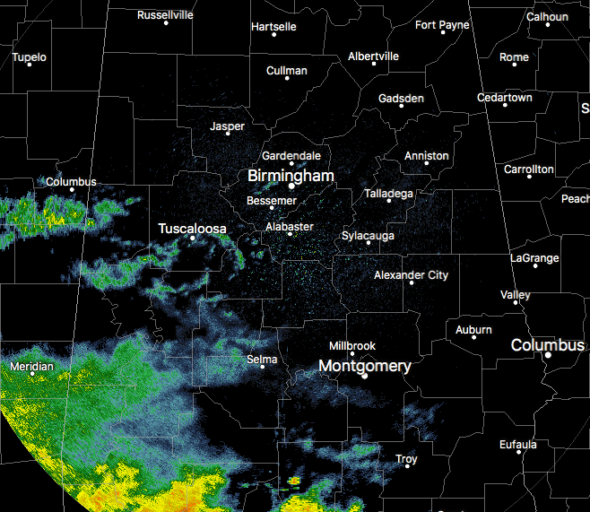
Moisture from Tropical Storm Harvey is moving into the southwestern parts of Central Alabama as we approach the 1:00 PM hour. Radar is currently showing some scattered shower activity mainly over portions of Tuscaloosa, Pickens, Sumter, Hale, Greene, Perry, and Dallas counties. Heavier activity is located over the southern parts of the state, but that will slowly be pushing to the north-northeast and will be affecting the southern portion of Central Alabama within an hour or two.
The Weather For The Rest Of Tuesday
Skies will remain mostly cloudy to completely overcast throughout the remainder of the day and rain chances will start to pick up in the southwestern parts of Central Alabama and move slowly to the north-northeast. There will be a chance of showers south of a line from Fayette to Birmingham to Alexander City, with increasing chances as you move southward. Afternoon highs will be in the lower to mid-80s. For this evening and into the overnight hours, chances of rain will increase for everyone in Central Alabama, with the better coverage in the southwestern locations as Harvey moves closer to the state. Overnight lows will be in the upper 60s to the lower 70s. Rainfall amounts through daybreak tomorrow will range from a trace in the northeastern locations to near 2.00 inches in the southwest.
A Soggy Wednesday In Store
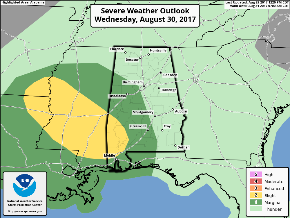
Tomorrow, the moisture will continue to flow in from Harvey, and well have showers with scattered thunderstorms throughout the day and into the evening and night time hours. There may be a few breaks in the rain, but expect tomorrow to be a pretty wet day. SPC has much of the western half of Central Alabama in a Marginal Risk for severe storms for the entire day, with the main risks coming from the possibility of those quick spin-up tornadoes that normally occur in tropical systems. Afternoon highs will top out in the lower to mid-80s throughout the area.
Harvey’s Moisture Hangs Around Through Friday
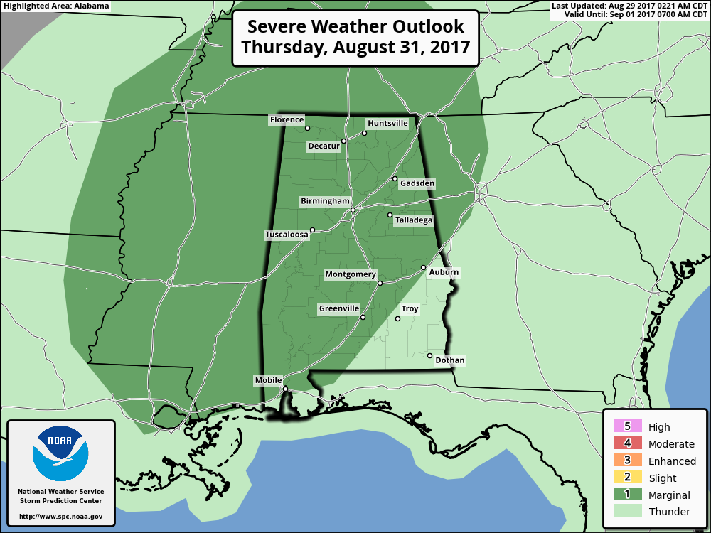
With Central Alabama continuing to be on the east side of the circulation of Harvey, we can expect periods of tropical rains with some embedded thunderstorms. Heaviest rain totals will be around the Gulf Coast, but totals will be pretty stout throughout the event as well. SPC has much of the state in a Marginal Risk for severe storms on Thursday, as those tropical-style spin up tornadoes will be possible. SPC may decide to carry that risk over into Friday as well. Highs will be in the lower to mid-80s. GFS estimates of 2-4 inches of rainfall through Friday night, with localized amounts of 5-6 inches. We may have a few flooding issues, so stay informed with the AlabamaWx Weather Blog.
The Central Alabama Weekend
Looks like the remaining moisture from Harvey will have moved out for the weekend, giving us a chance to dry out. There may be an isolated shower or two pop up in the southern parts of Central Alabama, but it now looks like nearly everyone will stay rain free. Skies will remain partly to mostly cloudy, and highs will be in the mid to upper 80s throughout the area on both days.
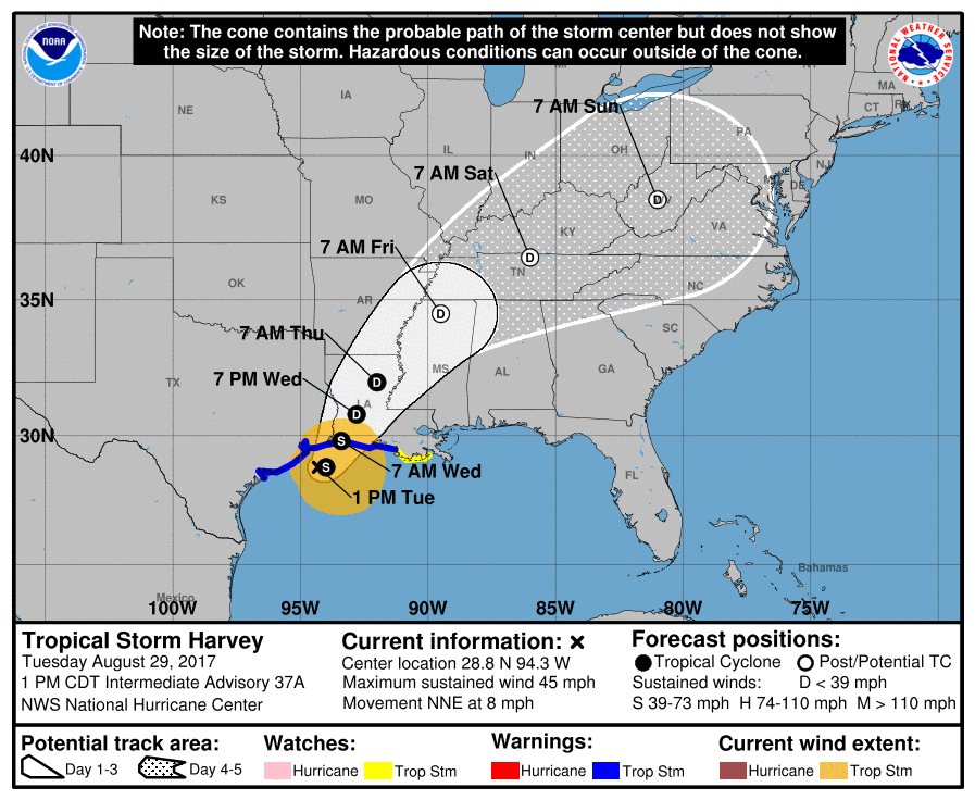
Latest On Harvey
The center of Tropical Storm Harvey is currently located over the Gulf of Mexico about 80 miles south-southwest of Port Arthur, Texas. Maximum sustained winds are still at 45 MPH but the movement has picked up in forward movement to the north-northeast at 8 MPH.
The center is expected to make landfall later tonight or early tomorrow morning and is expected to stay at the same strength until landfall. Catastrophic and life-threatening flooding continues in southeastern Texas and portions of southwestern Louisiana. Another 6-12 inches of rainfall is expected to fall over the upper Texas coast and southwestern Louisiana through Friday. Some locations are already nearing 50 inches of total rainfall.
The latest forecast track from the NHC has Harvey moving northeastwardly and losing strength finally. The center will be in northern Mississippi by Friday morning as a post-tropical depression, but the main focus will be for rainfall to the east and southeast of the center. It will be in central West Virginia on Sunday morning.
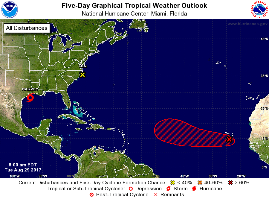
The Rest Of The Tropics
Potential Tropical Cyclone Ten continues to accelerate in forward speed towards the northeast at 20 MPH. It’s located over Pamlico Sound but is forecast to move away from the coast later today and into tonight. Maximum sustained winds are at 40 MPH, but the NHC states that Ten is not expected to develop into a tropical storm.
A tropical wave that is known as Invest 93L is currently located just south of the Cabo Verde Islands and moving west-northwestward at 15-20 MPH. It is expected to become a depression or Tropical Storm Irma within the 2 to 3 days. Most models have 93L approaching the east coast, but they do not go far enough out to see where its final destination will be. We’ll keep you updated.
Got Beach Plans?
Be sure to keep up to date with the detailed forecasts from Fort Morgan over to Panama City Beach with the AlabamaWx Weather Blog. Click here to see the AlabamaWx Beach Forecast Center page.
The Beach Forecast is partially underwritten by the support of Brett/Robinson Vacation Rentals in Gulf Shores and Orange Beach. Click here to see Brett/Robinson’s Hot Deals now!
Football Forecast
Alabama travels to Atlanta to take on Florida State Saturday in the new Mercedes-Benz Stadium indoors. Outside, it now looks like a decent part of the day Saturday will be dry with a mix of sun and clouds and just a few scattered showers. Temperatures will reach the lower to mid-80s in Atlanta Saturday afternoon.
Auburn will host Georgia Southern Saturday evening at Jordan-Hare Stadium and looks pretty decent with a partly cloudy sky and only a small risk of a shower. The kickoff temperature will be near 80 degrees, falling into the mid-70s by the final whistle.
UAB will host Alabama A&M Saturday afternoon at Legion Field and the forecast looks better with a mix of sun and clouds and only very slight risk of an isolated shower during the game. About 83 degrees at kickoff, then close to 80 by the end of the game.
Advertise With Us!
Now is the time to set your marketing campaign on AlabamaWX. The site has enjoyed a 71% jump in page views this year! The website has already enjoyed 10,157,915 page views this year. We can customize a creative, flexible and affordable package that will suit your organization’s needs. Contact Bill Murray at (205) 687-0782.
E-Forecast
Get the AlabamaWx seven-day forecast delivered directly to your inbox by email twice daily. It is the most detailed weather forecast available in Central Alabama. Click here to subscribe. It’s free!
WeatherBrains
Check out the show at www.WeatherBrains.com. You can also subscribe on iTunes. You can watch the show live at live.bigbrainsmedia.com on Monday nights starting at 8:30 PM CDT. You will be able to see the show on the James Spann 24×7 weather channel on cable or directly over the air on the dot 2 feed.
Category: Alabama's Weather, ALL POSTS
About the Author (Author Profile)
Scott Martin is an operational meteorologist, professional graphic artist, musician, husband, and father. Not only is Scott a member of the National Weather Association, but he is also the Central Alabama Chapter of the NWA president. Scott is also the co-founder of Racecast Weather, which provides forecasts for many racing series across the USA. He also supplies forecasts for the BassMaster Elite Series events including the BassMaster Classic.Subscribe
If you enjoyed this article, subscribe to receive more just like it.


