Severe Thunderstorm Warning Continues For Parts Of St. Clair, Shelby, And Talladega Counties Until 10:00PM

…A SEVERE THUNDERSTORM WARNING REMAINS IN EFFECT UNTIL 1000 PM CDT FOR WEST CENTRAL TALLADEGA…NORTHEASTERN SHELBY AND SOUTHWESTERN ST. CLAIR COUNTIES… At 944 PM CDT, severe thunderstorms were located along a line extending from near Odenville to Wilsonville, moving northeast at 40 mph.
HAZARD…60 mph wind gusts.
SOURCE…Radar indicated.
IMPACT…Expect damage to roofs, siding, and trees. Locations impacted include… Pell City, Moody, Childersburg, Wilsonville, Vincent, Harpersville, Alpine Bay Resort, Bald Rock, Logan Martin Lake, Coosa Island, Logan Martin Dam, Branchville, Country Club Estates, Wattsville, Sterrett, Chula Vista, Camp Winnataska, Cropwell and St. Clair County Airport.
Severe Thunderstorm Warning Continues For Parts Of St. Clair, Shelby, And Talladega Counties Until 10:00PM
Aug 31st @ 9:14 pm

…A SEVERE THUNDERSTORM WARNING REMAINS IN EFFECT UNTIL 1000 PM CDT FOR WEST CENTRAL TALLADEGA…EASTERN SHELBY AND SOUTHWESTERN ST. CLAIR COUNTIES… At 931 PM CDT, severe thunderstorms were located along a line extending from Bald Rock to Columbiana, moving northeast at 45 mph.
HAZARD…60 mph wind gusts.
SOURCE…Radar indicated.
IMPACT…Expect damage to roofs, siding, and trees. Locations impacted include… Pell City, Leeds, Moody, Chelsea, Childersburg, Columbiana, Wilsonville, Vincent, Harpersville, Westover, Alpine Bay Resort, Bald Rock, Vandiver, Logan Martin Lake, Coosa Island, Logan Martin Dam, Branchville, Country Club Estates, Wattsville and Sterrett.
Severe Thunderstorm Warning Canceled For Parts Of Jefferson County
Aug 31st @ 9:14 pm
…THE SEVERE THUNDERSTORM WARNING FOR EAST CENTRAL JEFFERSON COUNTY IS CANCELLED… The storms which prompted the warning have moved out of the warned area. Therefore, the warning has been cancelled. A tornado watch remains in effect until 1000 PM CDT for central and east central Alabama.
Severe Thunderstorm Warning Issued For Parts Of Jefferson, St. Clair, Shelby, And Talladega Counties Until 10:00PM
Aug 31st @ 9:14 pm
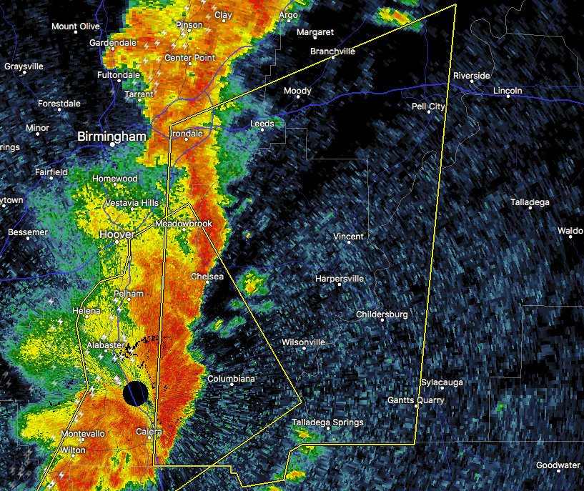

The National Weather Service in Birmingham has issued a
* Severe Thunderstorm Warning for…
Southwestern Talladega County in east central Alabama…
Shelby County in central Alabama…
East central Jefferson County in central Alabama…
Southwestern St. Clair County in central Alabama…
* Until 1000 PM CDT
* At 914 PM CDT, severe thunderstorms were located along a line extending from Greystone to near Calera, moving northeast at 40 mph.
HAZARD…60 mph wind gusts.
SOURCE…Radar indicated.
IMPACT…Expect damage to roofs, siding, and trees.
* Locations impacted include…
Vestavia Hills, Mountain Brook, Sylacauga, Pell City, Irondale, Leeds, Moody, Calera, Chelsea, Childersburg, Columbiana, Wilsonville, Talladega Springs, Indian Springs Village, Vincent, Harpersville, Westover, Alpine Bay Resort, Shops of Grand River and
Vandiver.
About the Author (Author Profile)
Subscribe
If you enjoyed this article, subscribe to receive more just like it.


