Saturday Night Notes On Irma
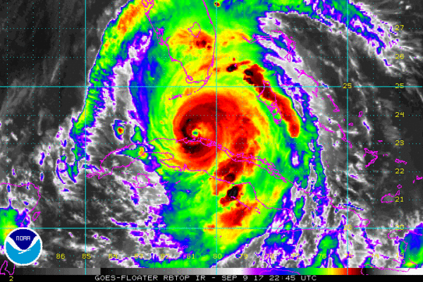
At 500 PM EDT, the eye of Hurricane Irma was located near latitude 23.4 North, longitude 80.5 West. Irma is moving toward the west-northwest near 9 mph. A northwest motion is expected to begin tonight with a turn toward the north-northwest on Sunday. On the forecast track, the core of Irma will continue to move near the north coast of Cuba during the next few hours, and will reach the Florida Keys Sunday morning. The hurricane is expected to move along or near the southwest coast of Florida Sunday afternoon.
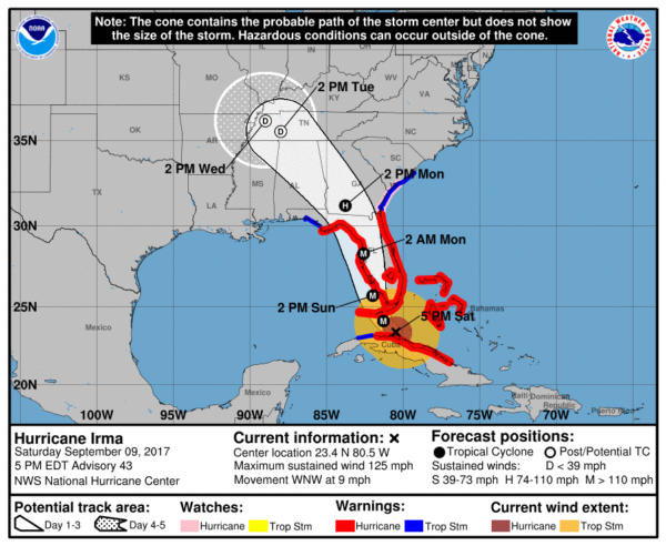
Maximum sustained winds are near 125 mph with higher gusts. Irma is a category 3 hurricane on the Saffir-Simpson Hurricane Wind Scale. Irma is forecast to restrengthen once it moves away from Cuba and remain a powerful hurricane as it approaches Florida.
Hurricane-force winds extend outward up to 70 miles from the center, and tropical-storm-force winds extend outward up to 195 miles. Ft. Lauderdale/Hollywood International airport recently reported a sustained wind of 47 mph and a gust of 70 mph. The latest minimum central pressure reported by a NOAA Hurricane Hunter plane was 933 mb (27.55 inches).
UPDATED IMPACT STATEMENTS:
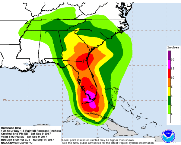
FLORIDA PENINSULA: A hurricane warning is in effect for all of the Florida Peninsula (not the Panhandle). Storm surge flooding, hurricane force winds, rain amounts of 6-12 inches, and a few tornadoes are likely for all cities; the most severe damage will be from Tampa Bay south to Key West, on the Florida West Coast.
From the Tampa NWS office…
– CURRENT THREAT TO LIFE AND PROPERTY: Extreme
– The wind threat has remained nearly steady from the
previous assessment.
– Emergency plans should include a reasonable threat for
major hurricane force wind greater than 110 mph of
equivalent Category 3 intensity or higher.
– To be safe, aggressively prepare for the potential of
devastating to catastrophic wind impacts. Remaining efforts
to secure properties should now be brought to completion.
– Extremely dangerous and life-threatening wind is possible.
Failure to adequately shelter may result in serious injury,
loss of life, or immense human suffering. Move to safe
shelter before the wind becomes hazardous.
– POTENTIAL IMPACTS: Devastating to Catastrophic
– Structural damage to sturdy buildings, some with complete
roof and wall failures. Complete destruction of mobile
homes. Damage greatly accentuated by large airborne
projectiles. Locations may be uninhabitable for weeks or
months.
– Numerous large trees snapped or uprooted along with fences
and roadway signs blown over.
– Many roads impassable from large debris, and more within
urban or heavily wooded places. Many bridges, causeways,
and access routes impassable.
– Widespread power and communications outages.
This is a very serious, life threatening storm. Evacuation orders MUST be followed. It is a matter of life and death for many.
Get specific impact statements from these Florida NWS offices…
FLORIDA PANHANDLE: Rain, if any, will be rather light for Pensacola, Navarre Beach, and Destin. It will be windy, of course, with a gusty north wind of 20-35 mph tomorrow through Monday. This is a dry, offshore flow.
At Panama City, they will most likely get into the outer rain shield of Irma Monday with north winds of 40-45 mph. They will remain on the “good” west side of the circulation, meaning an offshore flow and no storm surge issues. But, the sustained wind could knock down a few trees and bring scattered power outages.
Winds will be higher east of Panama City… Port St. Joe, Apalachicola, Cape San Blas will have winds of 40-55 mph Monday. Again, winds here will be out of the north and there will be no storm surge issues with an offshore flow. Tree and power line damage here is very possible, if not likely.
The Hurricane Watch west of the Aucilla River to Indian Pass has been upgraded to a Hurricane Warning, and the Tropical Storm Watch west of Indian Pass to the Okaloosa/Walton County Line has been upgraded to a Tropical Storm Warning.
ALABAMA GULF COAST: No rain for Dauphin Island, Gulf Shores, or Orange Beach. Monday will be windy with a north wind of 15-30 mph. Again, a dry, offshore flow.
The weather for the rest of next week (after Monday) on the Central Gulf Coast will be delightful with ample sunshine each day.
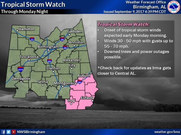
ALABAMA: We will be on the “good” west side of Irma, and there is no tornado risk anywhere in the state. The tornado threat is to the east on the “bad” east side of the circulation over Georgia and the Carolinas.
But, even on the “good side” it will become very windy Monday, Monday night, and Tuesday. Highest wind will be over the eastern third of the state. A tropical storm watch has been issued for Southeast Alabama…
Auburn University has cancelled classes Monday and suspended operations as a result of the wind potential.
Troy University cancelled classes Monday and Tuesday.
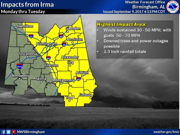
For the eastern half of Alabama, NWS Birmingham now projects winds Monday in the 30-50 mph range, with potential for gusts of 50-70 mph. This could result in downed trees and power lines.
Rain amounts across East Alabama should be in the 1-3 inch range. Isolated totals nearing 4 inches along the Alabama/Georgia line.
Winds across West Alabama will be lighter, in the 15-25 mph range. with rain amounts generally of one inch or less. No rain at all is expected in the broad area from Demopolis to Mobile, across Southwest Alabama.
GEORGIA: The circulation center of Irma will come up through Georgia; winds will average 45-60 mph Monday night and Tuesday morning with potential for gusts to 50 mph (this includes the Atlanta metro). This will bring potential for downed trees and power outages. Rain amounts of 2-4 inches are likely, with isolated amounts to 5 inches.
REMEMBER: You need to be working with current information. Using products that are over six hours old means you are using bad information. We will have frequent updates on the blog for the duration of this event…
Category: Alabama's Weather, ALL POSTS, Tropical
About the Author (Author Profile)
James Spann is one of the most recognized and trusted television meteorologists in the industry. He holds the AMS CCM designation and television seals from the AMS and NWA. He is a past winner of the Broadcast Meteorologist of the Year from both professional organizations.Subscribe
If you enjoyed this article, subscribe to receive more just like it.


