Scattered Showers & Storms Throughout Central Alabama At Midday
RADAR CHECK AT 12:05 PM
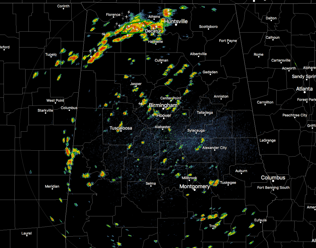
We have quite a few scattered showers and thunderstorms occurring across Central Alabama at the midday hour, but in northern Alabama heavy rainfall in the same general location has led to a Flash Flood Warning for parts of Lawrence County until 2:00 PM. These showers and storms are moving to the east-northeast and rainfall will continue in the same locations for a while longer. The towns of Town Creek, North Courtland, and Hillsboro are a few of the locations involved with this warning.
There is a cold pool that has formed out ahead of these storms and is making its way through Lawrence County and firing off more convective thunderstorms south of the Tennessee River into Morgan County. Training of cells is really starting to take shape and more flood advisories or warnings may be needed shortly. We’ll keep you informed.
With a weak shortwave aloft, some of these thunderstorms could be strong with very heavy downpours and wind gusts up to 50 MPH, along with very dangerous cloud-to-ground lightning. If you hear thunder, you are close enough to be struck by lightning. Go indoors immediately and stay inside until the storms has well passed your location.
At this point, the Storm Prediction Center does not have any part of Alabama in a severe weather risk throughout today, but we’ll keep an eye on that to see if that changes, especially since some of the recorded wind gusts from earlier storms in northern Alabama have been recorded as high as 59 MPH.
For the remainder of today we can expect partly to mostly cloudy skies with a decent chance of scattered showers and thunderstorms, some of which could be strong in nature. Main threats from these storms will be strong gusty winds and dangerous lightning. Some some locations, ponding and localized flash flooding could be possible especially with training of cells. Afternoon highs will be in the upper 80s to the lower 90s. We’ll have some showers and storms linger into the night time hours before diminishing, then some patchy dense fog may develop. Overnight lows will be in the upper 60s to the lower 70s.
For tomorrow, it will be another day with a mix of sun and clouds with a decent chance of scattered afternoon and early evening showers and thunderstorms. Afternoon highs will make it up into the upper 80s to the lower 90s once again. For the night time hours, a few showers and storms may linger but all rain should diminish before the overnight hours. Lows will be in the upper 60s to the lower 70s.
OUR TROPICAL WEATHER CATEGORY HAS THE LATEST ON ALL ACTIVE STORMS
Stay up-to-date with the latest updates on all of the tropical systems out in the Atlantic Ocean, Caribbean Sea, or in the Gulf of Mexico with the latest posts in our Tropical Weather section. Click here to see the latest.
GOT BEACH PLANS?
Be sure to keep up to date with the detailed forecasts from Fort Morgan over to Panama City Beach with the AlabamaWx Weather Blog. Click here to see the AlabamaWx Beach Forecast Center page.
The Beach Forecast is partially underwritten by the support of Brett/Robinson Vacation Rentals in Gulf Shores and Orange Beach. Click here to see Brett/Robinson’s Hot Deals now!
Category: Alabama's Weather, ALL POSTS
About the Author (Author Profile)
Scott Martin is an operational meteorologist, professional graphic artist, musician, husband, and father. Not only is Scott a member of the National Weather Association, but he is also the Central Alabama Chapter of the NWA president. Scott is also the co-founder of Racecast Weather, which provides forecasts for many racing series across the USA. He also supplies forecasts for the BassMaster Elite Series events including the BassMaster Classic.Subscribe
If you enjoyed this article, subscribe to receive more just like it.


