

Mostly Clear, Hot, & Humid at Midday
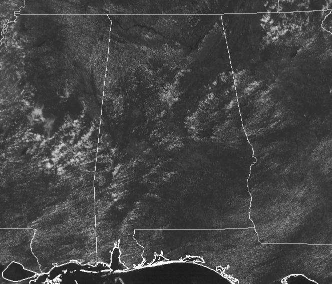
MOSTLY CLEAR SKIES ACROSS CENTRAL ALABAMA AT NOON
We only have a few cumulus clouds dotting the skies across Central Alabama at this point of the day, but I do expect a few more clouds to develop during the main heating part of the afternoon.
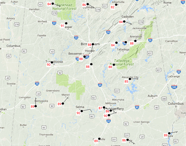
TEMPERATURES AT 12:20 PM
Temperatures across Central Alabama are currently running in the mid-80s to 90 degrees. The hot spots that are at 90 degrees are at Tuscaloosa, Selma, and Montgomery. Birmingham is not that far behind at 88 degrees.
FOR THE REST OF THE DAY
We’ll have more clouds develop throughout the afternoon hours, mainly during the hottest part of the day. Skies will be partly cloudy for most, with mostly cloudy skies for the rest in Central Alabama, with a chance of scattered showers and thunderstorms. Afternoon highs will top out in the upper 80s to the lower 90s throughout the area. For tonight’s high school football games, showers and storms will begin to decrease to begin the evening with skies becoming partly cloudy. Temperatures will be in the 80s throughout the area around 6:00 PM and dropping into the lower to mid-70s by 10:00 PM. Overnight lows will be in the mid-60s to near 70s, with some patchy fog developing mainly in areas where it rained or near bodies of water.
THE CENTRAL ALABAMA WEEKEND
We’ll continue this weather pattern to start off the first weekend in fall, as we’ll have a mix of sun and clouds on Saturday with a chance of isolated afternoon showers and thunderstorms. Highs will top out in the mid to upper 80s. On Sunday, we may have a wedge of slightly less moist air moving in from the east and this should keep rain chances really low for much of the area. We’ll have partly to mostly sunny skies, with a slight chance of an isolated shower or two in the southwestern parts of the area. Rain chances for the rest of Central Alabama look almost too low to even worry about. Highs will be in the mid to upper 80s.
THE WORK WEEK AHEAD
Even though rain chances look pretty slim on each day from Monday through Thursday, we can still mention a very small risk of an isolated shower or two. Skies will feature mostly sun and a few cumulus clouds, and highs will be in the mid to upper 80s with a few locations hitting 90 degrees. Friday will be the driest day of next week, with no rain expected at this time. A cold front will begin slowly moving through the state, with highs in the mid to upper 80s across much of the area, with upper 70s to the lower 80s possible the the extreme northern parts.
SATURDAY’S COLLEGE FOOTBALL WEATHER
Alabama travels up to Nashville to take on Vanderbilt, with kickoff around 2:30 PM. Temperature will start off near 88 degrees at kickoff and will fall into the mid-80s by the fourth quarter. Just a small chance of a brief shower or storm.
Auburn travels up to Columbia to take on Missouri, with kickoff around 6:30 PM. Temperature will start off around 85 degrees and will fall into the upper 70s by the end of the game. No rain is expected.
UAB travels out to the Lone Star State to take on North Texas, with kickoff around 5:30 PM. Temperature will start off around 90 degrees and will fall through the 80s during the game. No rain is expected.
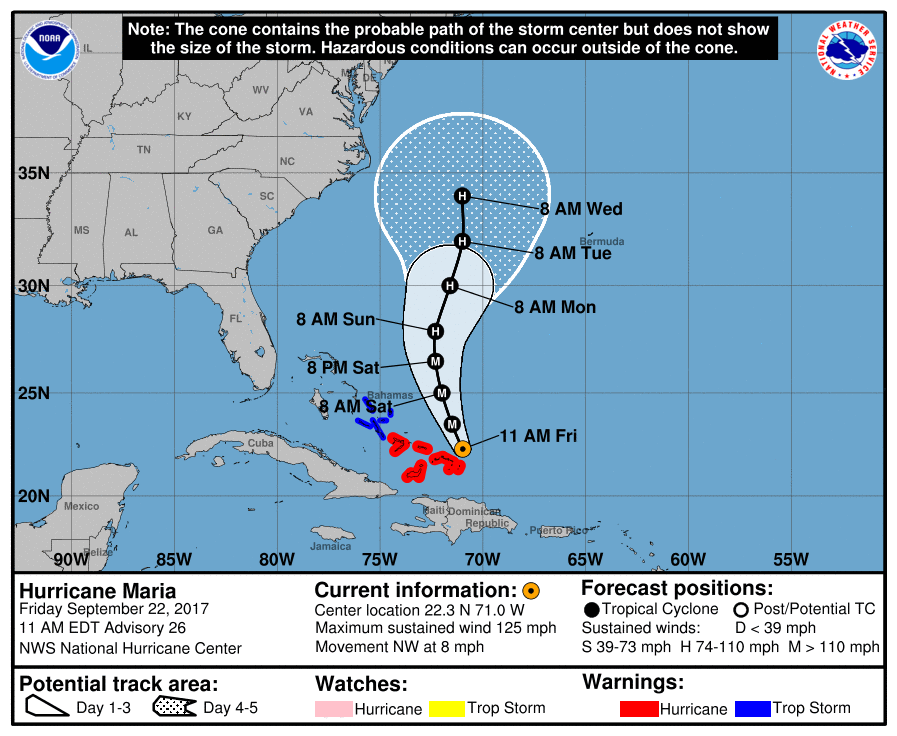
CATEGORY 3 HURRICANE MARIA
Maria is currently still a very strong hurricane, packing maximum sustained winds of 125 MPH as of the latest update. Movement is to the northwest at 8 MPH and is currently passing to the northeast of the Turks and Caicos Islands. Movement is forecast to become more northerly by Saturday and gradual weakening is expected to begin. By Sunday, Maria should drop back down to a category 2 storm and move generally to the north in between the US Mainland and the island of Bermuda. Just about all of the members in the latest guidance have Maria making a turn to the northeast about 6 or 7 days out and head away from the states.
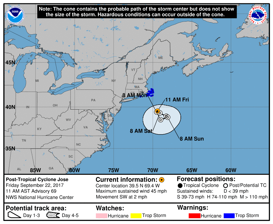
POST-TROPICAL STORM JOSE
Jose continues to gradually weaken but continues to bring tropical storm conditions to the southern parts of New England. Jose will meander around near the same location for the next few days while weakening into a post-tropical depression. Looks like Jose has provided enough weakening to the ridge to provide an escape route for Maria to start to exit, stage right.
OUR TROPICAL WEATHER CATEGORY HAS THE LATEST ON ALL ACTIVE STORMS
Stay up-to-date with the latest updates on all of the tropical systems out in the Atlantic Ocean, Caribbean Sea, or in the Gulf of Mexico with the latest posts in our Tropical Weather section. Click here to see the latest.
GOT BEACH PLANS?
Be sure to keep up to date with the detailed forecasts from Fort Morgan over to Panama City Beach with the AlabamaWx Weather Blog. Click here to see the AlabamaWx Beach Forecast Center page.
The Beach Forecast is partially underwritten by the support of Brett/Robinson Vacation Rentals in Gulf Shores and Orange Beach. Click here to see Brett/Robinson’s Hot Deals now!
ON THIS DAY IN WEATHER HISTORY
2005 – For the first time in the historical record, two hurricanes reached category-5 intensity in the Gulf of Mexico in a single season as Hurricane Rita intensified before making landfall (Katrina and Rita).
WEATHERBRAINS
Check out the show at www.WeatherBrains.com. You can also subscribe on iTunes. You can watch the show live at live.bigbrainsmedia.com on Monday nights starting at 8:30 PM CDT. You will be able to see the show on the James Spann 24×7 weather channel on cable or directly over the air on the dot 2 feed.
Category: Alabama's Weather, ALL POSTS
About the Author (Author Profile)
Scott Martin is an operational meteorologist, professional graphic artist, musician, husband, and father. Not only is Scott a member of the National Weather Association, but he is also the Central Alabama Chapter of the NWA president. Scott is also the co-founder of Racecast Weather, which provides forecasts for many racing series across the USA. He also supplies forecasts for the BassMaster Elite Series events including the BassMaster Classic.Subscribe
If you enjoyed this article, subscribe to receive more just like it.


