Notes on cold air, snow
1. The low of 12 in BHM this morning placed this morning in the 98.5 percentile for winter mornings (December through February), meaning only 1.5% of winter mornings (150 out of 10,194) since 1896 have been at least this cold. Our average temperature for today, assuming the high is 30 (the current temperature), will be 21, placing today in the 99th percentile. Below are charts of lows and average temps (number of occurrences of each) since 1896.
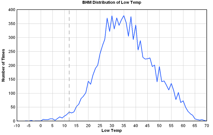
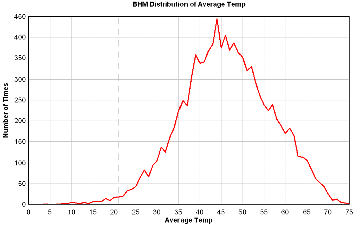
For you math people, these look like normal distributions. The median average temp is 45 and the median low temp is 35. (50% of all numbers are above the median).
2. BHM has been below freezing now for 23 continuous hours, and that number will likely make it to about 45 hours, before we go above freezing late tomorrow morning. We were above freezing for 4 hours yesterday, so we will have about 53 out of 57 consecutive hours below freezing.
3. The air density in BHM this morning at 7 am, with a temp of 12 and a pressure of 30.74″ (1040 mb), then adjusting for sea level, was about 1.34 kg/m3, about as high as it ever gets here. In the summer, it’s more like 1.12 kg/m3.
4. Various models are hinting at many scenarios that could bring some wintry precipitation in here sometime in the next few days, but none of them is real concrete at this point. A reinforcing shot of cold air will move in Sunday night. There could be some light precipitation with this, but the heavier precipitation should be to our south and east. The GEM suggests another chance of light snow Sunday night, and the European model spins up a low near the Gulf coast Monday night. Needless to say, we’ll need to watch the forecast carefully, since the models disagree and they have trouble with Arctic air. If the cold, dry air doesn’t modify as quickly tomorrow as the models predict, we could even see some light freezing rain early Sunday morning. Let’s just all relax, and see what the models, and the weather observations, show us tonight and tomorrow.
And then there’s this light snow showing up on radar, associated with an upper-level disturbance. Looks like it’s not reaching the ground, due to very dry air, but don’t surprised to see a few snow flakes this afternoon/evening. No accumulations or problems.

5. The cold air is not going anywhere in a hurry. It looks like, after a warmup into the 40s this weekend, highs Monday and Tuesday will be in the 30s again, with lows 20-25. So, don’t uncover the pipes and stuff yet.
Category: Uncategorized
About the Author (Author Profile)
Subscribe
If you enjoyed this article, subscribe to receive more just like it.


