Expected Coastal Impacts from Nate
Nate is now a hurricane tonight and is expected to continue to strengthen until landfall. Winds are forecast to reach 85 mph, but could be higher. In fact, Nate could become a category 2 hurricane before landfall. There is an outside chance it could become a major hurricane.
The 10 pm update to the forecast edges it a little further eastward, now bringing the center to near the Alabama/Mississippi border about 3 a.m. Sunday morning.
This, of course, increases the chance of a worst-case scenario for coastal Mobile and Baldwin Counties and ramps up the impacts along the Florida coast. Let’s dig into the details.
MOBILE/BALDWIN COUNTIES
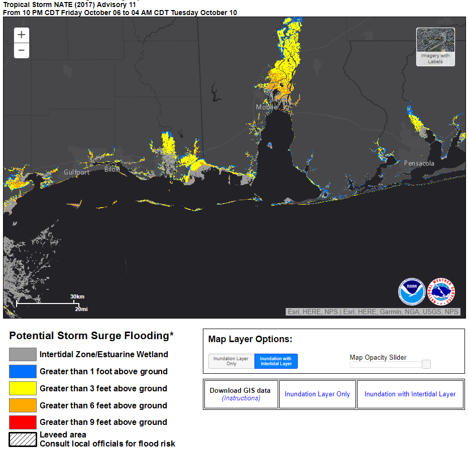
…Winds could reach 75-85 mph with gusts to 115 mph over southern Mobile and Baldwin Counties, including Dauphin Island, Gulf Shores and Orange Beach. The City of Mobile will likely see hurricane force winds.
…Residents and visitors should prepare however for a 90-120 mph hurricane, in case Nate strengthens more than forecast.
…Storm surge will run 5-8 feet along beaches and northern reaches of Mobile Bay with some values to 9 feet.
…Flash flood watches are in effect through Sunday evening for expected rainfall of 4-8 inches.
…Tornadoes are possible.
…A voluntary evacuation is in effect south of AL-182 in Orange Beach and for RVs and Mobile Homes.
…Additional evacuations orders are possible Saturday morning.
…A curfew is in effect for Orange Beach and Gulf Shores for Saturday night.
PENSACOLA/NAVARRE
…Winds could reach 65-75 mph with gusts to 90 mph.
…Residents and visitors should prepare however for an 80-110 mph hurricane, in case Nate strengthens more than forecast or tracks further east.
…Storm surge could reach at least 4-6 feet with some 7 foot values.
…Flash flood watches are in effect through Sunday evening for expected rainfall of 4-6 inches.
…Isolated tornadoes are possible.
FT. WALTON/DESTIN
…Winds could reach 45-55 mph with gusts to 75 mph.
…Residents and visitors should prepare for a 70-90 mph hurricane.
…There is a good chance that winds could reach 74-110 mph however.
…Storm surge could reach 4-6 feet.
…Rainfall could reach 2-4 inches.
…Isolated tornadoes are possible.
SEASIDE/SANTA ROSA
…Winds could reach 35-45 mph with gusts to 65 mph.
…Storm surge could reach 2-4 feet.
…Rainfall could reach 1-3 inches.
…Isolated tornadoes are possible.
MISSISSIPPI GULF COAST
…Winds could reach 55-70 mph with gusts to 90 mph.
…Storm surge could reach 5-8 feet.
…Rainfall could reach 4-8 inches.
…Conditions are unfavorable for tornadoes.
NEW ORLEANS/SE LOUISIANA
…Winds could reach 40-50 mph with gusts to 65 mph.
…Storm surge could reach 5-8 feet.
…Rainfall could reach 1-3 inches.
…Conditions are unfavorable for tornadoes.
Residents and visitors along the coast from the Mississippi Coast eastward to Northwest Florida need to heed emergency information from local officials early Saturday morning.
Category: Headlines
About the Author (Author Profile)
Bill Murray is the President of The Weather Factory. He is the site's official weather historian and a weekend forecaster. He also anchors the site's severe weather coverage. Bill Murray is the proud holder of National Weather Association Digital Seal #0001 @wxhistorianSubscribe
If you enjoyed this article, subscribe to receive more just like it.


