Updates To Expectations In Central Alabama As Of 11:00 AM
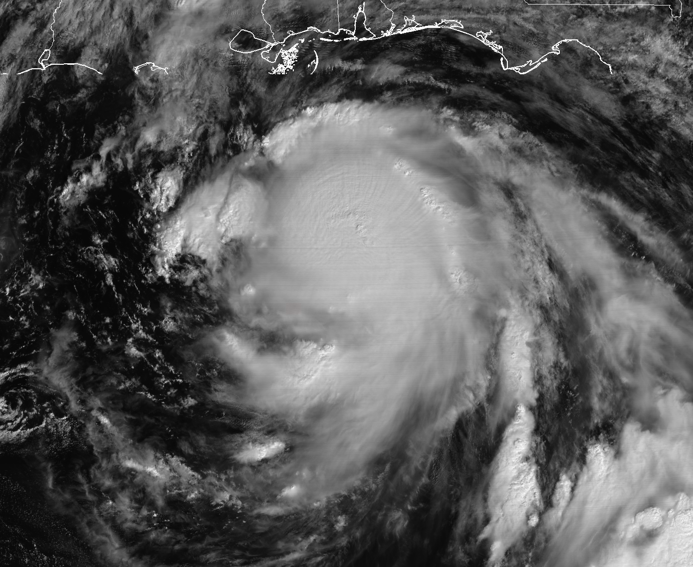
Nate continues to rapidly intensify this morning, with the latest maximum sustained winds now up to 90 MPH, and the minimum central pressure is down to 984mb. Movement is currently to the north-northwest at 26 MPH as of the update from the NHC at 10:00 AM. There has been a slight shift in the forecast path to the west by a few miles, but the overall threat still remains the same for Central Alabama. Here is the latest thinking with Hurricane Nate…
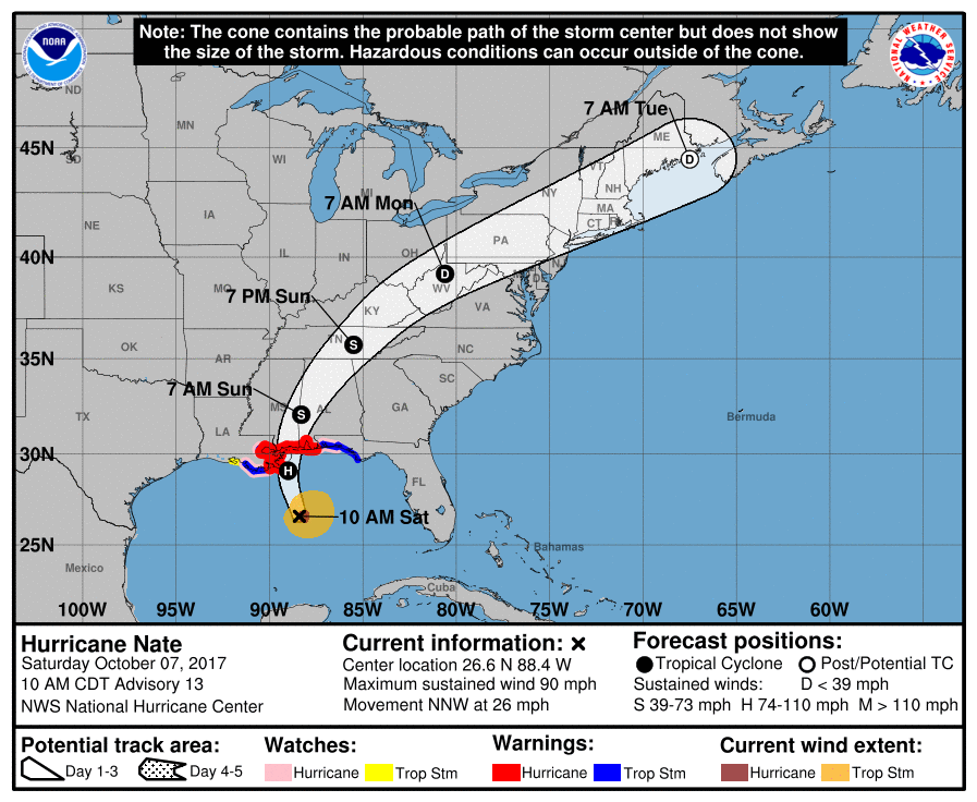
At the time of landfall, Nate will more than likely be a category 2 hurricane with maximum sustained wind speeds of 105-110 MPH. Landfall could occur earlier than midnight tonight with the increase in forward speed.
Timing of the strongest impacts from Nate in Central Alabama on Sunday will be from 3:00 AM to 12:00 PM for the southwestern parts of the area, 8:00 AM to 4:00 PM for the central parts (including the Birmingham Metropolitan Area), and from 12:00 PM to 7:00 PM for the northeastern parts.
With the increase in forward speed, Nate will become asymmetrical and the stronger winds will be on the eastern side of the center. Wind impacts will be significant across the area, as many trees and power lines are expected to fall with the strong winds. Wind gusts will be the strongest in the southwestern parts of the area and gradually weakening as the center progresses to the northeast.
The good news with the increase in forward speed is that it will lessen the tornado threat for those that will be east of the center. Another thing that will keep the tornado threat minimal is if the temperature stays below 80 degrees due to the rainfall and cloud cover. At this point, much if not all of the area should stay in the 70s for daytime highs on Sunday.
Even with the increase in forward speed, forecast rain amounts throughout tomorrow remain pretty much unchanged. Amounts will be highest closest to the center, with amounts of 2-4 inches expected. Amounts of 4-5 inches can be expected close to the center in the southwestern parts of the area. Away from the center, 1-3 inches will be possible. Some flooding will be an issue in parts of the area, especially in poor drainage areas and places where flooding is prone to happen.
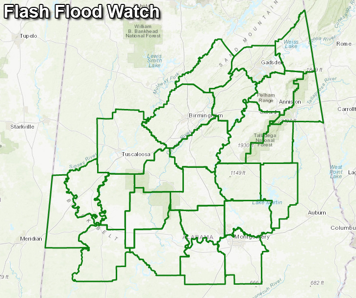
A Flash Flood Watch is in effect in Central Alabama from Saturday evening to Sunday evening for Autauga, Bibb, Blount, Calhoun, Cherokee, Chilton, Clay, Cleburne, Coosa, Dallas, Elmore, Etowah, Greene, Hale, Jefferson, Lowndes, Marengo, Montgomery, Perry, Shelby, St. Clair, Sumter, Talladega, Tallapoosa, and Tuscaloosa counties.
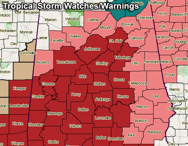
A Tropical Storm Watch is in effect until further notice for Barbour, Blount, Bullock, Calhoun, Chambers, Cherokee, Clay, Cleburne, Coffee, Dale, Etowah, Fayette, Geneva, Lee, Macon, Pickens, Pike, Randolph, Russell, Tallapoosa, and Walker counties.
A Tropical Storm Warning is in effect until further notice for Autauga, Bibb, Butler, Chilton, Choctaw, Clarke, Conecuh, Coosa, Covington, Crenshaw, Dallas, Elmore, Escambia, Greene, Hale, Jefferson, Lowndes, Marengo, Monroe, Montgomery, Perry, Shelby, St. Clair, Sumter, Talladega, Tuscaloosa, Washington, and Wilcox counties.
Best advice is to stay off the roads if possible on Sunday. Have your safety kits ready, fresh batteries installed in your radios and flashlights, and smartphones fully charged. Keep up to date with the latest weather information with your NOAA WeatherRadio, the ABC 33/40 Weather Team, the NWS Birmingham social media feeds, and the AlabamaWx Weather Blog.
Category: Alabama's Weather, ALL POSTS
About the Author (Author Profile)
Scott Martin is an operational meteorologist, professional graphic artist, musician, husband, and father. Not only is Scott a member of the National Weather Association, but he is also the Central Alabama Chapter of the NWA president. Scott is also the co-founder of Racecast Weather, which provides forecasts for many racing series across the USA. He also supplies forecasts for the BassMaster Elite Series events including the BassMaster Classic.Subscribe
If you enjoyed this article, subscribe to receive more just like it.


