Latest Update On Conditions At The Beach
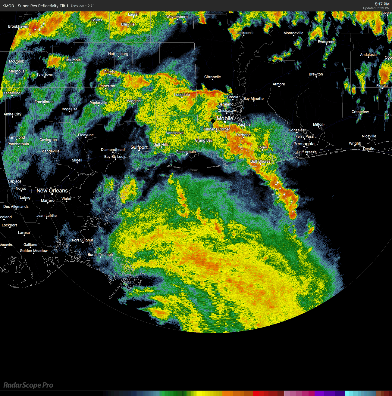
Hurricane Nate is currently less than 120 miles away from making landfall on the coastline very close to the Gulfport and Biloxi areas in Mississippi.
CURRENT WATCHES & WARNINGS ALONG THE GULF COAST
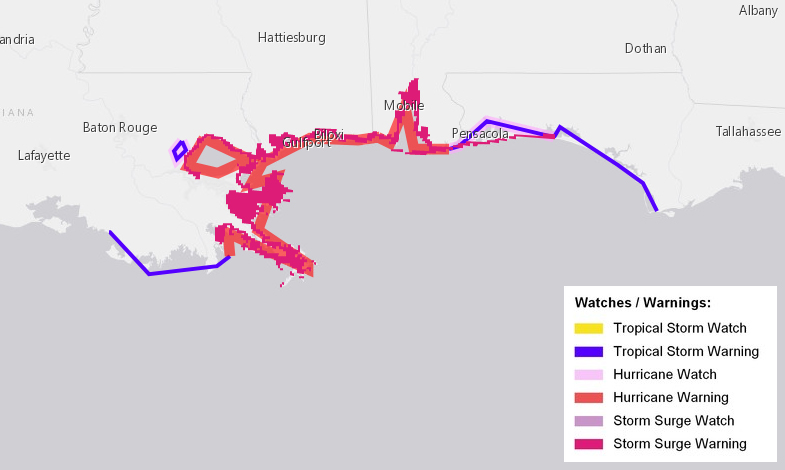
A Hurricane Warning is in effect for…
* Grand Isle Louisiana to the Alabama/Florida border
* Metropolitan New Orleans and Lake Pontchartrain
A Storm Surge Warning is in effect for…
* Grand Isle Louisiana to the Okaloosa/Walton County Line Florida
* Northern and western shores of Lake Pontchartrain
A Tropical Storm Warning is in effect for…
* Lake Maurepas
* West of Grand Isle to Morgan City Louisiana
* East of the Alabama/Florida border to Indian Pass Florida
A Hurricane Watch is in effect for…
* Lake Maurepas
* East of the Alabama/Florida border to the Okaloosa/Walton County Line
WATCHES & WARNINGS THAT HAVE BEEN RECENTLY DISCONTINUED
* Storm Surge Warning west of Grand Isle.
* Hurricane Watch from west of Grand Isle to Morgan City.
* Storm Surge Watch east of the Okaloosa/Walton County Line to Indian Pass.
* Tropical Storm Watch from west of Morgan City to Intracoastal City.
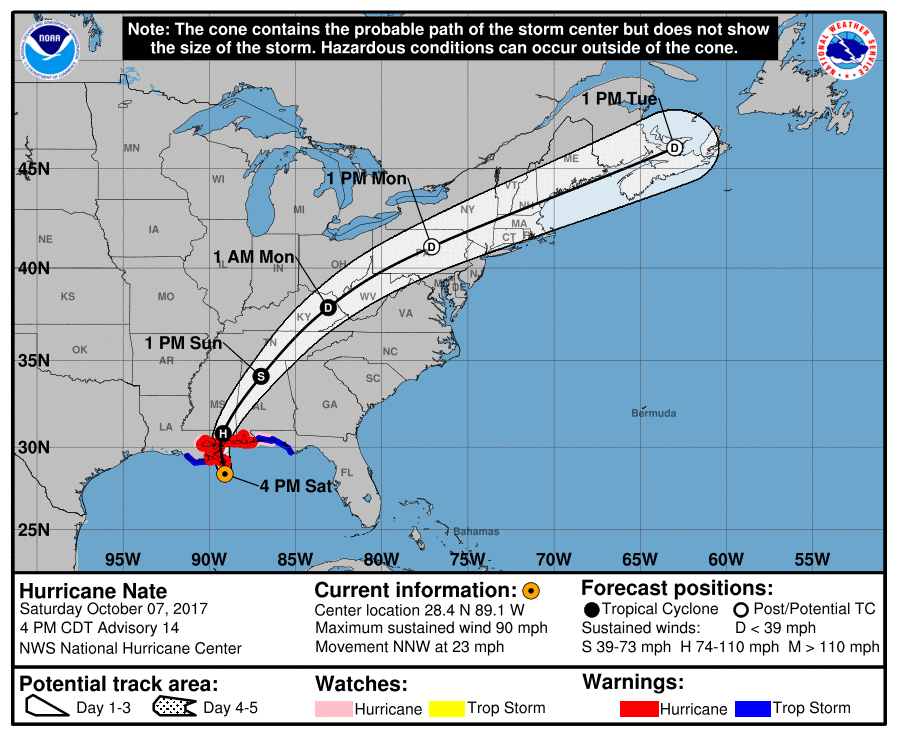
Category 1 Hurricane Nate continues to maintain strength with maximum sustained winds of 90 MPH, as it heads north-northwest at 23 MPH toward the Gulf Coast. It is forecast to make landfall along the northern Gulf Coast later tonight Saturday into early Sunday morning.
Conditions along the Mississippi, Alabama, and western Florida Panhandle Gulf Coast will continue to deteriorate throughout the evening and nighttime hours until after the center of Nate makes landfall around or just after midnight tonight.
Tropical storm force winds will be likely very shortly along the coast persisting into early Sunday morning. Depending on where the center makes landfall later tonight, hurricane force winds could be possible, mainly closest to the center. At this point with the latest NHC track, the center will make landfall near Gulfport and Biloxi around midnight as a strong category 1 or minimum category 2 hurricane.
The combination of a dangerous storm surge and the tide will cause normally dry areas near the coast to be flooded by rising waters moving inland from the shoreline. The water is expected to reach the following heights above ground if the peak surge occurs at the time of high tide…
Mouth of the Mississippi River to the Mississippi/Alabama border…7 to 11 ft
Mississippi/Alabama border to the Alabama/Florida border, including Mobile Bay…6 to 9 ft
Alabama/Florida border to the Okaloosa/Walton County Line…4 to 6 ft
Grand Isle, Louisiana to the mouth of the Mississippi River…2 to 4 ft
Okaloosa/Walton County Line to Indian Pass, Florida…2 to 3 ft
Indian Pass to Crystal River, Florida…1 to 3 ft
Morgan City, Louisiana to Grand Isle…1 to 2 ft
The deepest water will occur along the immediate coast near and to the east of the landfall location, where the surge will be accompanied by large and destructive waves. Surge-related flooding depends on the relative timing of the surge and the tidal cycle, and can vary greatly over short distances.
Along with the storm surge, life-threatening rip currents and surf will be battering the beaches from now until at least Sunday afternoon. If you have no business being in the water, DON’T GO IN. All beaches in Alabama are closed to the public, including the state park property.
With the current forecast landfall to occur near Gulfport and Biloxi, all of the Alabama Gulf Coast and the western Florida Panhandle will have an elevated threat for tornadoes from now until around Sunday morning. Once the center passes by, the tornado threat will be over.
We can also see rainfall totals of 3-6 inches with heavier localized amounts possible, which could lead or help exacerbate flooding.
Time is running out before Nate makes landfall. Preparations to protect life and property need to be completed immediately.
About the Author (Author Profile)
Scott Martin is an operational meteorologist, professional graphic artist, musician, husband, and father. Not only is Scott a member of the National Weather Association, but he is also the Central Alabama Chapter of the NWA president. Scott is also the co-founder of Racecast Weather, which provides forecasts for many racing series across the USA. He also supplies forecasts for the BassMaster Elite Series events including the BassMaster Classic.Subscribe
If you enjoyed this article, subscribe to receive more just like it.


