Tornado Watch Issued For Parts of South Mississippi, South Alabama, & West Florida
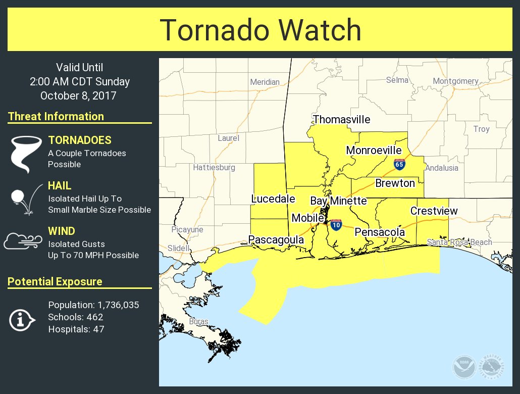
THE NATIONAL WEATHER SERVICE HAS ISSUED TORNADO WATCH 497 IN
EFFECT UNTIL 2 AM CDT SUNDAY FOR THE FOLLOWING AREAS
IN ALABAMA THIS WATCH INCLUDES 7 COUNTIES
IN SOUTH CENTRAL ALABAMA
CONECUH ESCAMBIA MONROE
IN SOUTHWEST ALABAMA
BALDWIN CLARKE MOBILE
WASHINGTON
IN FLORIDA THIS WATCH INCLUDES 3 COUNTIES
IN NORTHWEST FLORIDA
ESCAMBIA OKALOOSA SANTA ROSA
IN MISSISSIPPI THIS WATCH INCLUDES 2 COUNTIES
IN SOUTHEAST MISSISSIPPI
GEORGE GREENE
THIS INCLUDES THE CITIES OF ATMORE, BAY MINETTE, BELLVIEW, BRENT,
BREWTON, CHATOM, CRESTVIEW, DAPHNE, DESTIN, EGLIN AFB, ENSLEY,
EVERGREEN, FERRY PASS, FLOMATON, FORT WALTON BEACH, GROVE HILL,
GULF BREEZE, GULF SHORES, HOMEWOOD, JACKSON, LEAKESVILLE,
LUCEDALE, MCLAIN, MILLRY, MILTON, MOBILE, MONROEVILLE,
MYRTLE GROVE, NICEVILLE, PACE, PENSACOLA, PRICHARD, SARALAND,
SEMINOLE, THOMASVILLE, TILLMANS CORNER, AND WRIGHT.
THE NATIONAL WEATHER SERVICE HAS ISSUED TORNADO WATCH 497 IN
EFFECT UNTIL 2 AM CDT SUNDAY FOR THE FOLLOWING AREAS
THIS WATCH INCLUDES THE FOLLOWING ADJACENT COASTAL WATERS
NORTHERN MOBILE BAY SOUTHERN MOBILE BAY MISSISSIPPI SOUND
PERDIDO BAY PENSACOLA BAY SYSTEM CHOCTAWHATCHEE BAY
COASTAL WATERS FROM PENSACOLA FL TO PASCAGOULA MS OUT 20 NM
COASTAL WATERS FROM DESTIN TO PENSACOLA FL OUT 20 NM
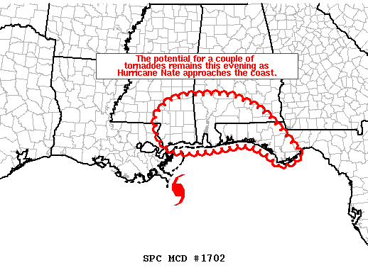
The potential for a few tornadoes will persist this evening across portions of southern Mississippi, southern Alabama and perhaps the Florida Panhandle as Hurricane Nate approaches.
As Hurricane Nate approaches the northern Gulf Coast, deep layer shear has increased and isolated embedded stronger cells have begun moving onshore. A few of these cells have shown low level rotation and a water spout was even reported in the vicinity of Mobile Bay. However, most of these features have been weak. Regardless, helicity values greater than 250 m2/s2 and favorable low level wind profiles will continue support the potential for a brief tornado in the strongest low-topped supercell structures as they move onshore and migrate north-northwestward this evening.
Category: Archived Warnings
About the Author (Author Profile)
Scott Martin is an operational meteorologist, professional graphic artist, musician, husband, and father. Not only is Scott a member of the National Weather Association, but he is also the Central Alabama Chapter of the NWA president. Scott is also the co-founder of Racecast Weather, which provides forecasts for many racing series across the USA. He also supplies forecasts for the BassMaster Elite Series events including the BassMaster Classic.Subscribe
If you enjoyed this article, subscribe to receive more just like it.


