Maximum Sunshine At Midday Tuesday Across Central Alabama
What’s Happening With Our Weather At 11:25 AM
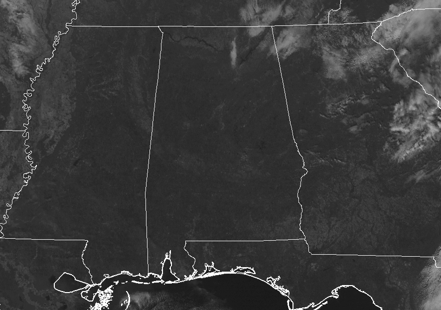
Looking at the latest visible satellite image across the southeastern United States, all of Central Alabama can enjoy maximum sunshine at this point. The only clouds in the state are just a few in the northeastern corner. Temperatures throughout Central Alabama at 11:25 AM were running in the upper 50s to the lower 60s. Birmingham is at 59 degrees at the moment, while the warm spots are down in the southeast at Troy and Eufaula currently at 64 degrees.
Weather For The Rest Of Your Tuesday
With high pressure well off to the north-northeast of Alabama, we’ll have a cool easterly flow over the area today, keeping our daytime highs in the mid to upper 60s throughout. Skie will generally stay clear throughout the rest of the daytime and into the late night and overnight hours. Overnight lows will be in the upper 30s to the lower 40s.
Wednesday’s Weather
We will have a weak surface front will be approaching Central Alabama during the day and that will bring an increase in clouds to the area during the afternoon and evening hours. At this point, the airmass over the area is too dry for any organized showers to develop, but a few sprinkles may fall up in the northwestern parts during the night time and overnight hours. Daytime highs will be in the lower to mid-60s. With the extra cloud cover and slightly warmer dewpoint will keep the overnight lows in the mid-40s to the lower 50s.
The Tropics
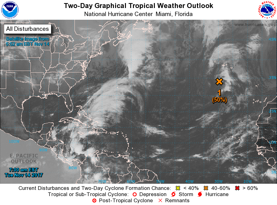
For the North Atlantic, Caribbean Sea and the Gulf of Mexico, a disturbance is located less than 300 miles to the south-southwest of the Azores and still shows the potential (50%) of possibly becoming a tropical depression within the next couple of days. It will continue to move slowly to the northeast, well away from the United States.
Stay up-to-date with the latest updates on all of the tropical systems out in the Atlantic Ocean, Caribbean Sea, or in the Gulf of Mexico with the latest posts in our Tropical Weather category. Click here to see the latest.
Gulf Coast Weather
Be sure to keep up to date with the detailed forecasts from Fort Morgan over to Panama City Beach with the AlabamaWx Weather Blog. Click here to see the AlabamaWx Beach Forecast Center page. The Beach Forecast is partially underwritten by the support of Brett/Robinson Vacation Rentals in Gulf Shores and Orange Beach. Click here to see Brett/Robinson’s Off Season Deals now!
On This Day In Weather History
1987 – The first major snowstorm of the season hit the Southern and Central Rockies, producing 12 inches at the Brian Head ski resort in Utah overnight. Strong and gusty winds associated with the storm reached 52 mph at Ruidoso NM. In the eastern U.S., the temperature at Washington D.C. soared to 68 degrees, just three days after being buried under more than a foot of snow.
WeatherBrains
Check out the show at www.WeatherBrains.com. You can also subscribe on iTunes. You can watch the show live at live.bigbrainsmedia.com on Monday nights starting at 8:30 PM CDT. You will be able to see the show on the James Spann 24×7 weather channel on cable or directly over the air on the dot 2 feed.
Category: Alabama's Weather, ALL POSTS
About the Author (Author Profile)
Scott Martin is an operational meteorologist, professional graphic artist, musician, husband, and father. Not only is Scott a member of the National Weather Association, but he is also the Central Alabama Chapter of the NWA president. Scott is also the co-founder of Racecast Weather, which provides forecasts for many racing series across the USA. He also supplies forecasts for the BassMaster Elite Series events including the BassMaster Classic.Subscribe
If you enjoyed this article, subscribe to receive more just like it.


