Severe Thunderstorm Warning Expired For Parts Of Limestone County
…THE SEVERE THUNDERSTORM WARNING FOR NORTHEASTERN LIMESTONE COUNTY
WILL EXPIRE AT 600 PM CST…
The storms which prompted the warning have moved out of the area.
Therefore the warning will be allowed to expire.
Severe Thunderstorm Warning Continues For Parts Of Limestone County Until 7:00PM
Nov 18th @ 5:23 pm

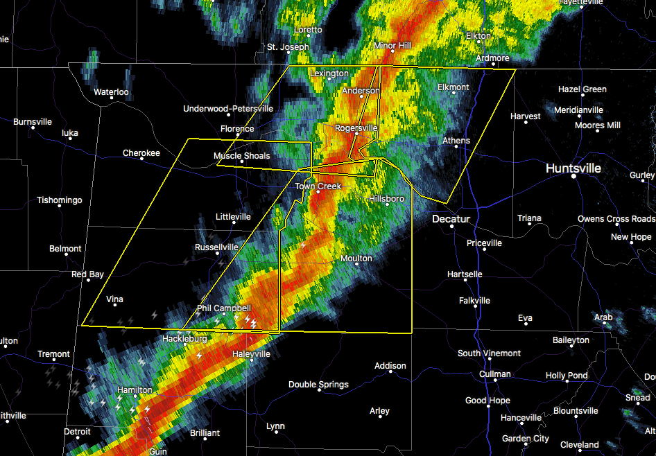
…A SEVERE THUNDERSTORM WARNING REMAINS IN EFFECT UNTIL 600 PM CST FOR NORTHEASTERN LIMESTONE COUNTY… At 545 PM CST, severe thunderstorms were located along a line extending from 6 miles north of Ardmore to near Athens, moving east at 55 mph.
HAZARD…60 mph wind gusts.
SOURCE…Radar indicated.
IMPACT…Expect damage to roofs, siding, and trees. Locations impacted include… Ardmore, Elkmont and Holland Gin.
Severe Thunderstorm Warning Canceled For Parts Of Lauderdale County
Nov 18th @ 5:23 pm
…THE SEVERE THUNDERSTORM WARNING FOR SOUTHEASTERN LAUDERDALE COUNTY IS CANCELLED… The storms which prompted the warning have moved out of the warned area. Therefore, the warning has been cancelled.
Severe Thunderstorm Warning Issued For Parts Of Lauderdale And Limestone Counties Until 6:00PM
Nov 18th @ 5:23 pm

The National Weather Service in Huntsville Alabama has issued a
* Severe Thunderstorm Warning for…
Southeastern Lauderdale County in northwestern Alabama…
Limestone County in north central Alabama…
* Until 600 PM CST
* At 522 PM CST, severe thunderstorms were located along a line extending from 11 miles east of Lexington to near Rogersville, moving east at 55 mph.
HAZARD…60 mph wind gusts.
SOURCE…Radar indicated.
IMPACT…Expect damage to roofs, siding, and trees.
* Locations impacted include…
Decatur, Athens, Rogersville, Ardmore, Tanner, Elkmont, Lester, Good Springs, Cartwright and Coxey.
Category: Archived Warnings
About the Author (Author Profile)
Subscribe
If you enjoyed this article, subscribe to receive more just like it.


