Severe Thunderstorm Warning Canceled For Parts Of Jackson And Franklin (TN) Counties
…THE SEVERE THUNDERSTORM WARNING FOR NORTH CENTRAL JACKSON AND SOUTHEASTERN FRANKLIN COUNTIES IS CANCELLED… The storms which prompted the warning have moved out of the area. Therefore the warning has been cancelled.
Severe Thunderstorm Warning Continues For Parts Of Jackson And Franklin (TN) Counties Until 7:00PM
Nov 18th @ 6:09 pm

…A SEVERE THUNDERSTORM WARNING REMAINS IN EFFECT UNTIL 700 PM CST FOR NORTH CENTRAL JACKSON AND SOUTHEASTERN FRANKLIN COUNTIES… At 641 PM CST, severe thunderstorms were located along a line extending from 7 miles north of Gruetli-Laager to 10 miles northwest of Stevenson, moving east at 65 mph.
HAZARD…60 mph wind gusts.
SOURCE…Radar indicated.
IMPACT…Expect damage to roofs, siding, and trees. Locations impacted include… Monteagle, Sewanee, Anderson, Hytop, Jericho, St. Andrews and Sherwood.
Severe Thunderstorm Warning Continues For Parts Of Jackson And Franklin (TN) Counties Until 8:00PM
Nov 18th @ 6:09 pm

…A SEVERE THUNDERSTORM WARNING REMAINS IN EFFECT UNTIL 700 PM CST FOR NORTHWESTERN JACKSON AND FRANKLIN COUNTIES… At 626 PM CST, severe thunderstorms were located along a line extending from 11 miles east of Manchester to 9 miles south of Huntland, moving east at 65 mph.
HAZARD…60 mph wind gusts.
SOURCE…Radar indicated.
IMPACT…Expect damage to roofs, siding, and trees. Locations impacted include… Winchester, Decherd, Cowan, Monteagle, Sewanee, Tims Ford Lake, Anderson, Hytop, Jericho and Maxwell.
Severe Thunderstorm Warning Issued For Parts Of Jackson, Madison, Franklin (TN), Lincoln (TN), And Moore (TN) Counties Until 7:00PM
Nov 18th @ 6:09 pm
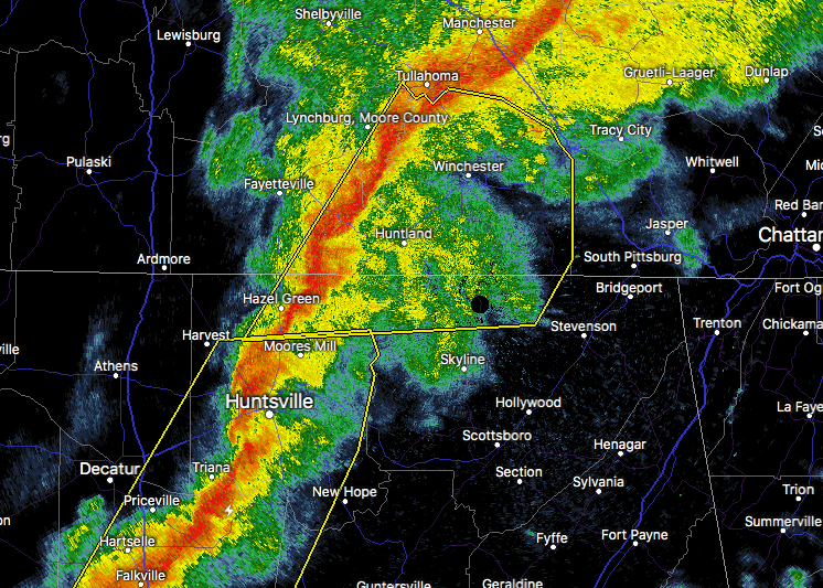

The National Weather Service in Huntsville Alabama has issued a
* Severe Thunderstorm Warning for…
Northwestern Jackson County in northeastern Alabama…
Northeastern Madison County in north central Alabama…
Southeastern Moore County in Middle Tennessee…
Southeastern Lincoln County in Middle Tennessee…
Franklin County in Middle Tennessee…
* Until 700 PM CST
* At 609 PM CST, severe thunderstorms were located along a line extending from Tullahoma to Meridianville, moving east at 65 mph.
HAZARD…60 mph wind gusts.
SOURCE…Radar indicated.
IMPACT…Expect damage to roofs, siding, and trees.
* Locations impacted include…
Winchester, Meridianville, Moores Mill, Hazel Green, Decherd, Estill Springs, Cowan, Monteagle, Huntland and Tims Ford Lake.
Category: Archived Warnings
About the Author (Author Profile)
Subscribe
If you enjoyed this article, subscribe to receive more just like it.


