More complete update now
With a lot more information in now, including the 12Z UKMET, NOGAPS, and looking at some current info, here’s what we can say right now. Since it’s a Saturday and people reading here are interested in weather, I’ll throw in some technical stuff. This is probably my longest blog post ever.
Current situation: Temperatures warming over the SE with full sunshine and SW winds. The temps are having trouble in northern Kentucky where ice/snow are still on the ground, creating fog and low clouds, but those are melting/evaporating quickly (satellite pictures). Note temperatures in northern Arkansas in the 60s! That’s good news for power crews, and will melt any remaining ice fast. Warm air will keep moving in through tomorrow morning, and with sunshine tomorrow we could hit 60. So, cold air is not in place for the potential winter storm.
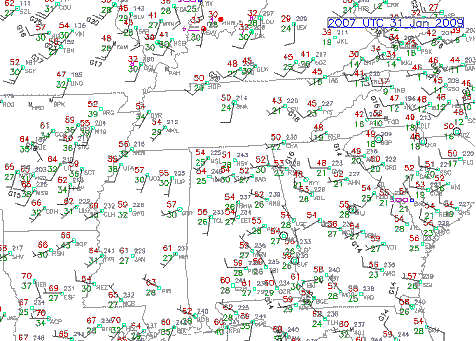
Current surface
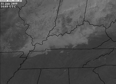
Visible satellite
Overall pattern: A cold front will move into Alabama on Monday, as an upper-level trough moves by to the north. At the same time, weak impulses in the southern stream may develop additional precipitation, and a weak surface low, in the Gulf. The low will probably be associated with some precipitation, but most of that should stay south of BHM, and should be rain.
As the front moves in, it will encounter more moist air, helping to setoff precipitation. It will also will be in a position known as a “col”, with low pressure to the north and south, and high pressure to the east and west. This may cause confluence of air along the front, increasing the strength of the front. As this happens, the main vertical motion is on the warm side of the front, and this seems to be the case here.
Also remember that cold air moving into an area tends to suppress precipitation. The reason for this is, most simply put, the temperature of an air parcel moving along can’t change without some heat being added to it or taken away from it. As a cold air parcel moves into warmer air, it tends to be heavier than the surroundings and sink a little. This is oversimplified, but a good way to think about it. And, it explains why, so often, the precipitation ends as the cold air moves in.
Models: NAM shows precip lasting until Monday afternoon, with the air becoming cold enough for snow right at the end. GFS shows about the same thing, about 3 hours faster. 18 UTC NAM shows more precipitation, so some area from Tupelo to Huntsville may see an accumulation on roads. The GFS and NAM both indicate that temperatures will be above freezing at BHM throughout the precip event…not going below freezing until Monday night after 10 pm. Maybe this will be an event where snow accumulates on grass and cars enough to look nice but doesn’t accumulate on roads. Farther north, if the NAM is correct and there is heavier precip, that will help to lower surface temperatures by melting. NOGAPS shows all precipitation staying south of MGM…don’t know if I buy that, but that looks like where most of it will be. The Canadian and UKMET are colder, and even though they keep most of the precipitation south of BHM, they show enough along the front so that we could get 1-2″ in north and central AL. But, the UKMET keeps BHM temps above freezing until Monday night, also, so no big problems on roads here. The European looks similar to the UKMET. (Graphics below). One may question the colder models a little, given the warm air in place over the southeast today and tomorrow.
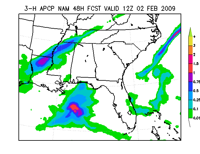
NAM 3-hr precip
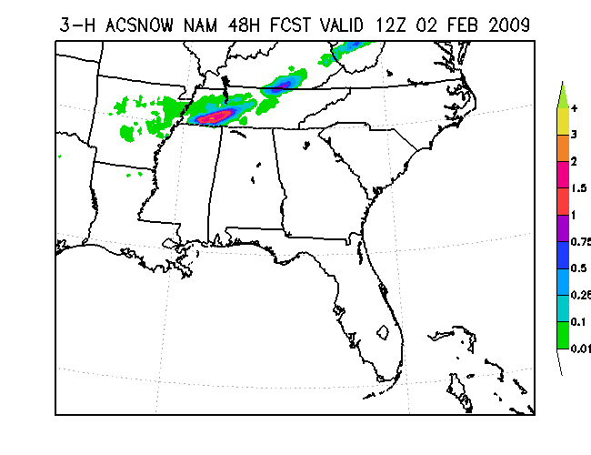
NAM 3-hr snow
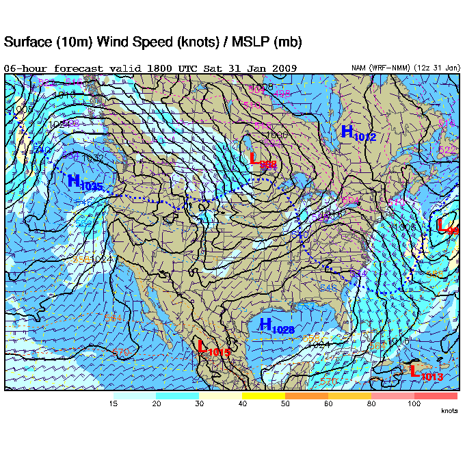
NAM MSLP
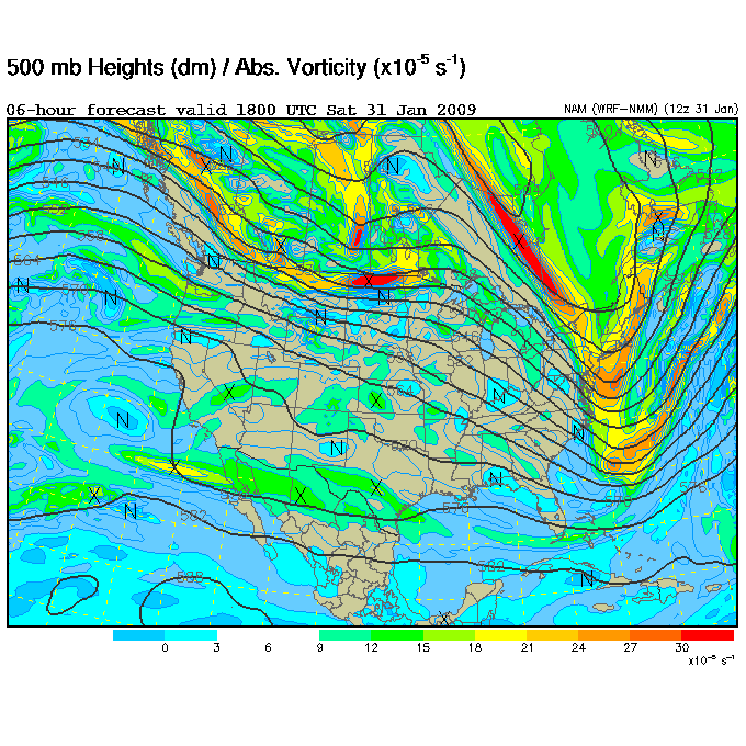
NAM 500 mb
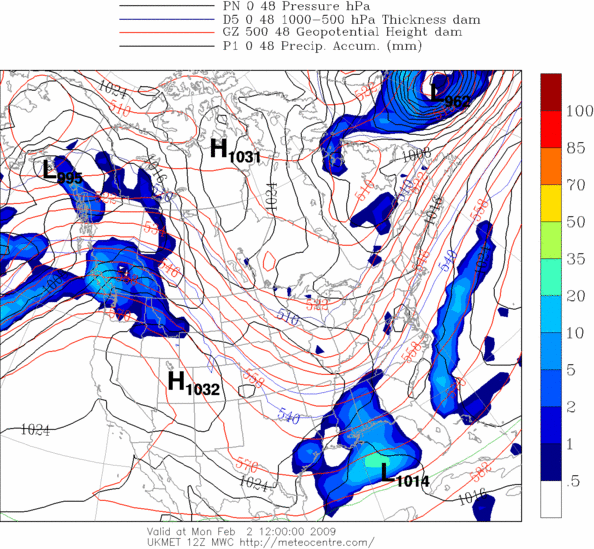
UKMET thickness and precip
Analysis:
We still don’t know. Given warm ground temperatures and the low being weaker and farther south than previously thought, this does not look like a major winter storm for BHM. North Alabama will likely see rain changing to snow Monday morning, and BHM will change to snow by late afternoon. By then, most of the heavier precipitation could be moving away. I’d say the best forecast right now is for a 1-3″ accumulation in the Tennessee Valley, and maybe up to 1″ in BHM. More than likely, the roads will stay OK during the day on Monday, especially south of Cullman, with the warm ground and cold air moving in late. The travel problems could come Monday night, as any wet roads may freeze as temperatures go below freezing. If you want a big-time (4″) snow in BHM, it doesn’t look likely right now, and schools will probably be open by Tuesday afternoon. The weather is a hard to forecast, and the models could change a lot between now and Monday. So, all this could be wrong anyway. To forecast the weather more exactly, we would need soundings (balloon data with profiles of temperature and wind) in every county of the U.S. and every 10 square miles in the ocean, every hour, and computers with hundreds of TB of RAM to run the models. Still, we’d make mistakes, especially more than 5 days out. And, we could get another upper level impulse Tuesday with some light snow.
Category: Uncategorized
About the Author (Author Profile)
Subscribe
If you enjoyed this article, subscribe to receive more just like it.


