

A Look at Morning Model Data for the Upcoming Winter Weather Event
Insight from Bill Murray and Scott Martin
A crazy, Deep South December snow is setting up for tomorrow as moisture overruns cold air in place in places that don’t see much snow ever, and certainly not this early in the winter season. Not that we can’t have December snows in the Alabama and the Deep South, but this is an unusual event for sure.
Brownsville, Texas could see measurable snow for only the third time in its history. Certainly parts of South and West Texas could see decent snow accumulations. New Orleans could pick up ¼ to ½ inch. Southern Mississippi could see 2-3 inches. I remember that happening several years
On December 14, 1997, a surprise snowstorm dumped as much as ten inches of snow across Central Mississippi and four inches into West Alabama. That was caused by dynamic cooling with an upper low. This event will be different, with overrunning of a cold air mass coming in from the north.
This event could be more similar to the December 4, 2009, event in southern Mississippi and Louisiana. According to the NWS in Jackson:
Colder air was moving southward into the area as light rain developed over Northeast Louisiana and Southwest Mississippi late Friday afternoon. The precipitation quickly changed to all snow by evening and then moved eastward across Central and South Mississippi during the night, becoming heavy at times south of the Interstate 20 corridor. A significant amount of rain fell initially along the Interstate 59 corridor before changing to snow late Friday evening. All precipitation exited eastern portions of the ArkLaMiss shortly after midnight.
As was the case with last year’s December snowstorm, very little if any snow fell in extreme Southeast Arkansas and North Central Mississippi. Light snow fell along the Interstate 20 corridor with up to an inch falling from Jackson to Meridian in Central Mississippi. The heaviest snow fell along the Highway 84 corridor, where amounts ranged from two to five inches. Below is a listing of measurable snowfall reports to date, in inches.
The latest model data is coming in. Here are some notes:
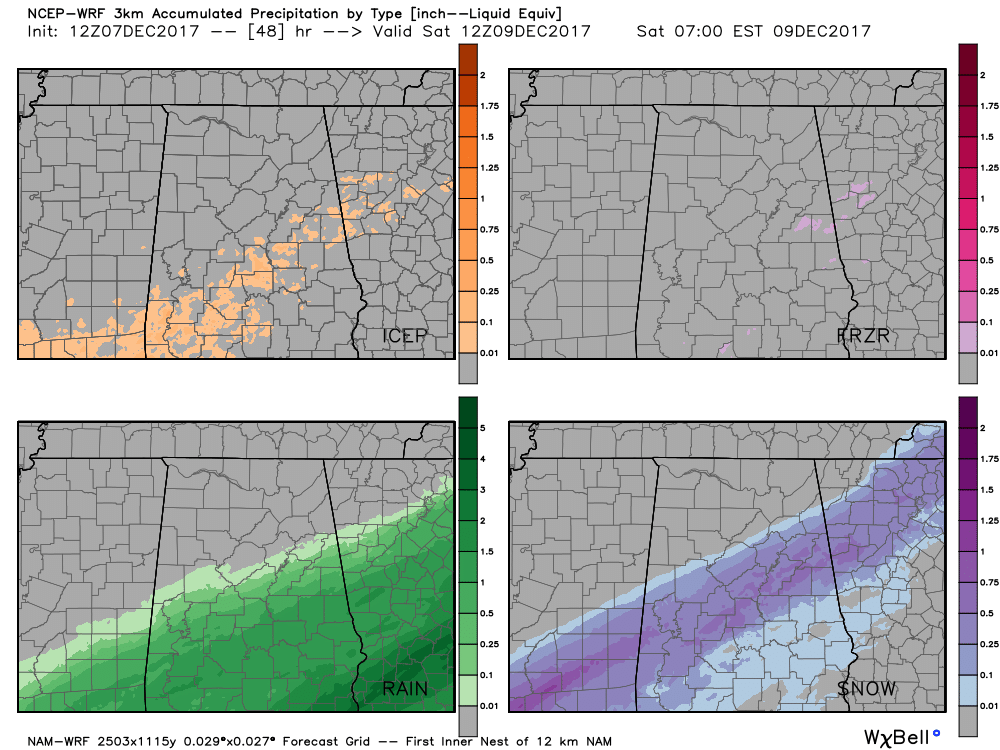
3km NAM
This model shows snow breaking out this evening across eastern Texas into southwestern Mississippi before midnight with snow beginning to mix with the rain on the northern edge of the precipitation shield into Central Alabama just after midnight tonight. The snow increases across Southern Mississippi through the morning hours, with decent accumulating snows of up to four inches in places like Hazelhurst, Brookhaven and Newton Mississippi. The model has accumulating snow in a 50 mile wide corridor along and south of I-20 in Central Alabama. It would be consistent with ½-2 inches of snow in spots. There is some sleet mixed in with the snow over Central Alabama with some freezing rain in counties like Clay, Randolph and Chambers late in the event Friday afternoon into the evening. Ice accumulations should be light.
GFS
The 12z data is in for the GFS and has the morning hours starting off with mainly rain for the locations along and south of the I-20/59 and the I-20 corridor. As we reach the noon hour, the northern edge of the rain shield will have turned into either snow or a rain/snow mix. Areas along and south of Livingston to Chelsea to Fruithurst could start to see snow showers at that point, but accumulations are not expected as the ground temperatures at that point will still be well-above freezing. At that point the snow band will probably only be about 20-40 miles wide, and anything south of that band will remain rain at this point.
As we move into the evening hours, the snow band widens as we lose the heating of the day and temperatures begin to decline. As we hit the 6:00 PM hour, the snow band is forecast to be along and south of a line from Cuba to Jemison to Ranburne. At this point, accumulations should begin as the soil temperatures will have dropped enough, especially in grassy areas. The snow band will be 50-75 miles wide, with everyone south of that having rain. To the north of the snow band, all rain and snow activity will have come to an end.
For the rest of the night, the band of snow will continue to progress eastward into Georgia, but some snow showers or freezing rain could progress into the pre-dawn hours. Accumulations will be possible overnight, but overall through the event, the GFS is showing a range of accumulations amounting from a dusting up to 2 inches, with the higher accumulations occurring in the southeastern corner of Central Alabama (Tallapoosa, Chambers, Elmore, Lee, and Coosa counties). For this model run, no accumulations for the Birmingham metropolitan area, Tuscaloosa, Anniston, or points north of those.
EURO
Last night’s run of the Euro shows a dusting of snow in the I-20/59 Corridor by 6 a.m. Friday morning, with snow continuing through the morning hours along and south of I-20. UNder this scenario, some folks in places like Dempolis, Selma, Alex City picking up 1 inch of snow with isolated spots to around 2 inches. Places like southern Sumter, Greene, Hale, Bibb, Shelby and Talladega Counties into southern Calhoun and Cleburne Counties could see up to an inch. Birmingham, Tuscaloosa, Gadsden and Anniston could see ¼ to ½ inch with the heavier amounts just to the south.
BOTTOM LINE
So there is decent consistency among the models that we will have a stripe of snow somewhere across Central Alabama starting late tonight into Friday. General amounts should be ¼ and ½ inch, with several spots recording at least one inch, especially over East Central Alabama. But there will be some surprises, with higher amounts in any areas that get decent precipitation rates with enough cold air through the atmosphere for it to fall all the way to the ground as snow.
Ground temperatures are still relatively warm, but will be cooling. Most of the accumulation should be on grassy areas, but in areas that see heavier accumulation, it could begin to collect on roads and bridges and there could be slick spots.
So, bottom line is be prepared for potential travel problems, especially tomorrow morning, in the Winter Weather Advisory area. The problems could last through the day in areas which see heavier snow accumulation. Moisture on roads will freeze in some areas Friday night, causing more potential problems.
BE PREPARED FOR SURPRISES
Many folks may get no snow accumulation, and many no snow at all. But there will be some places that get a dusting to 1 inch, and some spots that get a surprise with a little more, up to 2 inches.
Needless to say, the is an evolving winter weather situation and one we will have to watch carefully. Pay very close attention to the latest information right here on the AlabamaWX blog, which is now in Winter Weather Mode.
Category: Alabama's Weather, ALL POSTS, Winter Weather
About the Author (Author Profile)
Scott Martin is an operational meteorologist, professional graphic artist, musician, husband, and father. Not only is Scott a member of the National Weather Association, but he is also the Central Alabama Chapter of the NWA president. Scott is also the co-founder of Racecast Weather, which provides forecasts for many racing series across the USA. He also supplies forecasts for the BassMaster Elite Series events including the BassMaster Classic.Subscribe
If you enjoyed this article, subscribe to receive more just like it.


