A Quick Update And A Look At The Models
By Scott Martin and Bill Murray
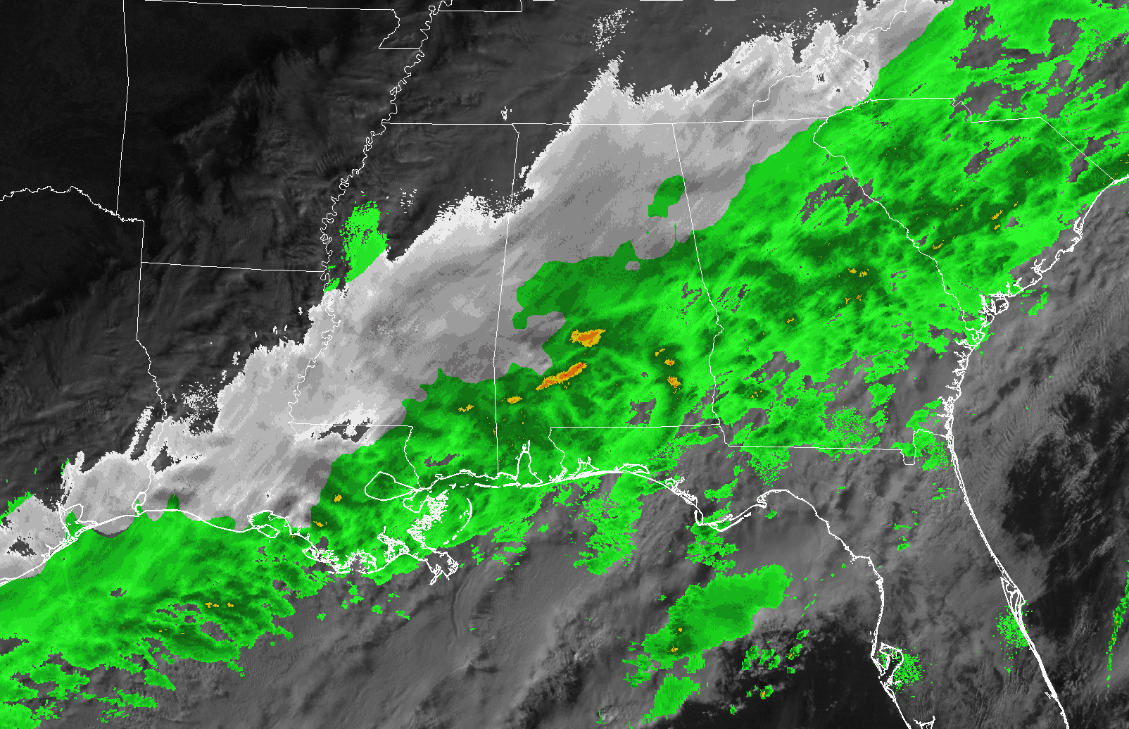
Snow continues to be widespread and heavy in places across Central Alabama this morning. Heavy snowfall rates are overcoming warmer road temperatures and causing snow covered roads. Some of the main reports of dangerous road conditions are coming from Chilton, Shelby, Talladega and Calhoun Counties. They likely extend into parts of the other winter storm warning counties.
Many schools that were on delay are now closing for the day.
The winter storm warning is in effect until midnight tonight for Bibb, Calhoun, Chilton, Clay, Cleburne, Coosa, Greene, Hale, Jefferson, Marengo, Perry, Randolph, Shelby, St. Clair, Sumter, Talladega, Tallapoosa and Tuscaloosa Counties.
A winter weather advisory is in effect for other counties, including: Autauga, Blount, Chambers, Cherokee, Dallas, Elmore, Etowah, Fayette, Lamar, Pickens and Walker Counties. It is in effect until midnight.
Snowfall continues solidly back to the Mississippi River with some snow all the way back to Alexandria LA. Many times, heavy snowfall will cause surface temperatures to continue to drop, creating a feedback loop that results in more heavy snowfall.
Slick spots are now being reported on bridges in Center Point by the Jefferson County Sherrif’s Department.
Our weather models all continue to depict snow, heavy at times through early this afternoon.
Meteorologist Scott Martin has a look at the latest model data:

GFS Precipitation Type valid at noon today.
GFS
Looks like the GFS is handling this system really well as it has the snowfall pretty much where it is occurring at this point, and looks like it is jiving well with the consensus of the forecasts. The snow band will be centered over and just south of the I-20/59 and the I-20 corridors throughout the morning and into the midday hours, with the snowfall actually intensifying as we get closer to the noon hour. The band starts an eastward progression into the evening hours, and flurries or light snow showers are possible for locations along and east of a line from Fort Payne to Birmingham to Demopolis. Locations to the west of that line will be precipitation free. The GFS is keeping flurries or light snow showers over the eastern parts of Central Alabama throughout the pre-dawn hours up to midday on Saturday.
EURO
This model run is keeping the main snowfall along and north of the I-20 corridor through the morning and into the midday hours, and quickly dissipating the snow into a smaller area for the evening and into the midnight hour. Some light to moderate snow showers will persist over the east and northeastern locations of Central Alabama through midnight and should be out of the state by sunrise on Saturday.
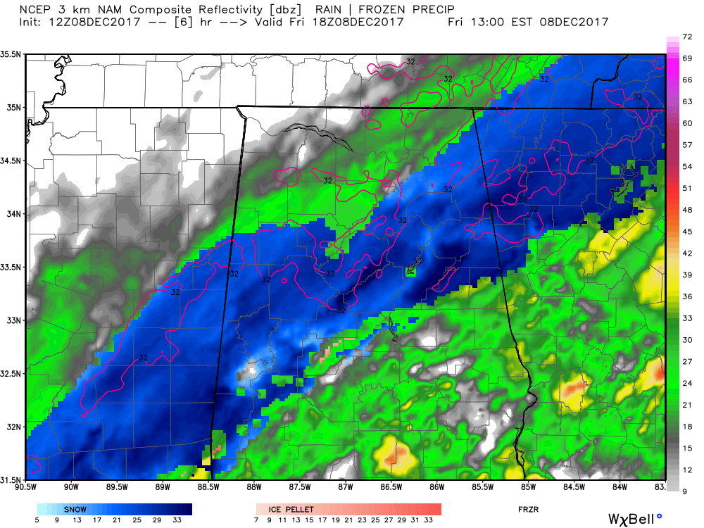
NAM3k Simulated Radar valid at noon today.
NAM3k
The main snowband will continue to be over the I-20/59, I-20, and I-59 corridors from now through noon, with the snow activity starting to dissipate around 1:00 PM. The band thins out and moves southeastward through the southern parts of the area during the late afternoon and early evening hours, but persisting throughout the overnight hours in the east and southeastern parts of Central Alabama until finally moving out by 7-9AM Saturday morning.
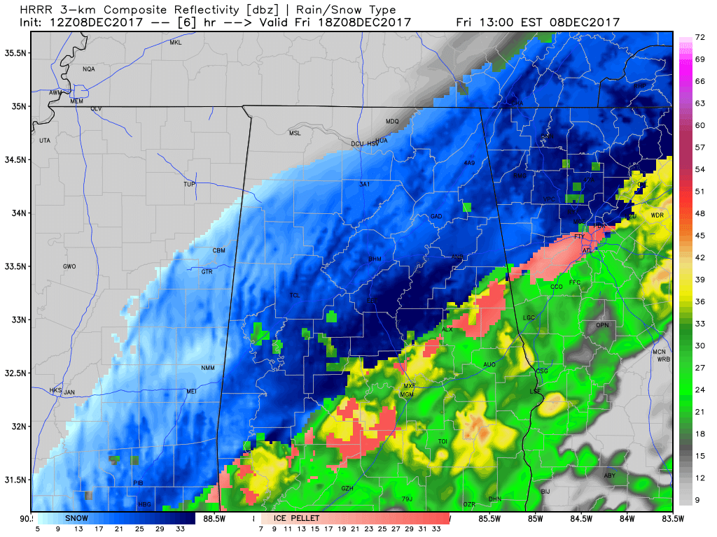
HRRR Simulated Radar valid at noon today.
HRRR
The latest run of the HRRR is showing a heavy snow band continuing on the northern side of the precipitation persisting along and south of the I-20/59 and I-20 corridors from now through the rest of the morning and into the noon hour before the moisture starts to dissipate. The snow band will quickly shrink off to the east and much of Central Alabama will be moisture free by 4-5PM today. Rain activity may linger across the extreme southern and the southeastern parts of the area, with most of that being rain. A few snow showers or sleet may be mixed in with the rain shield, but nothing like we are seeing now.
With all of that model data, the best chance for accumulating snow will come from now until the mid-afternoon hours for locations in a 50-mile swath along the I-20/59 and I-59 corridors, with accumulation chances dissipating throughout the early evening hours. I believe the National Weather Service is good with their forecast totals for today. Limited accumulations could be expected over the eastern parts of the area during the overnight and into the morning hours on Saturday.
Category: Alabama's Weather, ALL POSTS
About the Author (Author Profile)
Scott Martin is an operational meteorologist, professional graphic artist, musician, husband, and father. Not only is Scott a member of the National Weather Association, but he is also the Central Alabama Chapter of the NWA president. Scott is also the co-founder of Racecast Weather, which provides forecasts for many racing series across the USA. He also supplies forecasts for the BassMaster Elite Series events including the BassMaster Classic.Subscribe
If you enjoyed this article, subscribe to receive more just like it.


