A Later Than Midday Look At Central Alabama’s Weather
RADAR CHECK AT 2:10PM
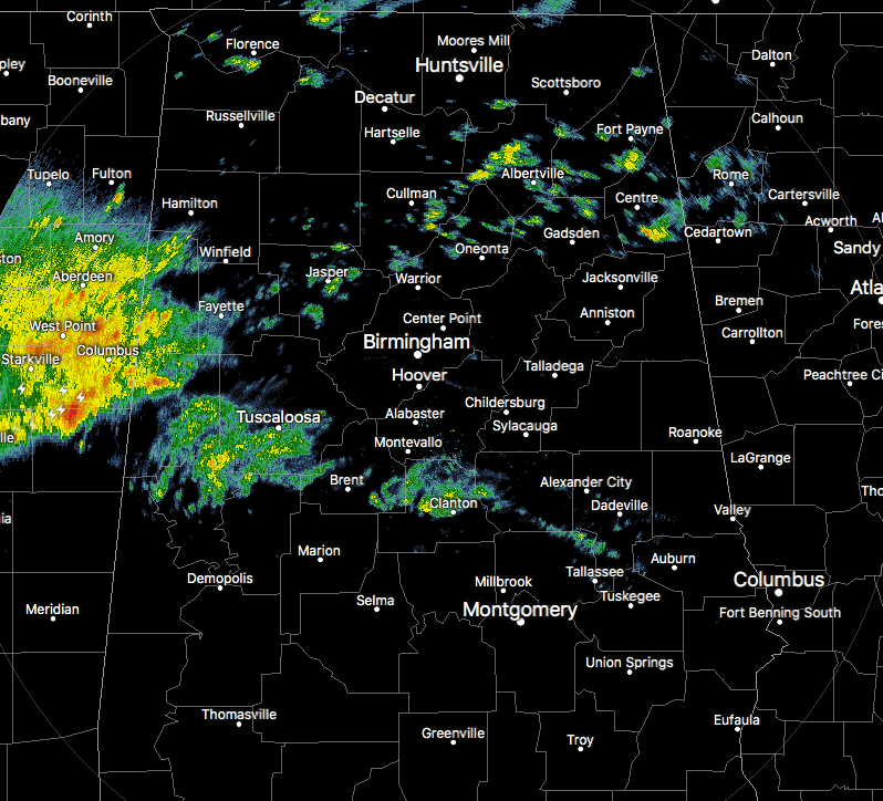
At this point on your Tuesday, we have widely scattered showers over a good bit of Central Alabama, but heavier showers and thunderstorms are moving into the western parts of the area as I type this post. No severe weather is being reported at this time, and none is expected for Central Alabama for the rest of the day. We do expect strong to marginally severe storms throughout a good bit of the day on Wednesday.
If it is not raining in your “neck of the woods” at this point, skies are mainly cloudy with temperatures ranging from the upper 50s to the mid-60s for the northern half, and the mid-60s to the lower 70s in the south. Birmingham was at 64ºF at 2:15 PM, while the warm spot is 70ºF down in Troy.
WEATHER FOR THE REST OF THE DAY
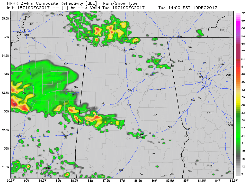
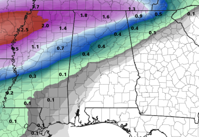
HRRR Simulated Radar from 2PM Tuesday to 6AM Wednesday.
We’ll continue to have widely scattered showers across much of the area throughout the remainder of the afternoon and into the early evening hours, while a shield of more moderate to heavy rainfall with embedded thunderstorms moves in from the west and mainly affect areas north of the I-20 corridor. Afternoon highs will range throughout the 60s to the lower 70s from north to south.
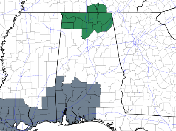
NWS Huntsville has issued a Flash Flood Watch starting at 9:00 PM tonight through 12:00 PM on Wednesday for the following counties in North Alabama: Colbert, Cullman, De Kalb, Franklin, Jackson, Lauderdale, Lawrence, Limestone, Madison, Marshall, and Morgan. Periods of heavy showers and thunderstorms will overspread the area this evening and tonight and persist into the morning hours of Wednesday. Rainfall amounts of 2 to 3 inches are likely over most of the area, with locally higher amounts possible. The resulting excessive runoff may lead to flash flooding, particularly in poor drainage areas and low water crossings.
For tonight, it will pretty much be the same news, with scattered showers and thunderstorms in the south with heavier rain and thunderstorms likely for the north. Rainfall totals through 6:00 AM Wednesday will be none to 1/2 inch south of I-20, with 1/2 inch up to 1 inch or slightly more north of that. Overnight lows will be in the mid-50s to the lower 60s.
THIS DAY IN WEATHER HISTORY
1777 – The Continental Army moved into encampment at Valley Forge amidst stormy winds and piercing cold. A relatively moderate winter followed.
1924 – The Riverside Ranger Station in Yellowstone Park, WY, reported a low of 59 degrees below zero, a December record for the U.S.
1957 – A tornado, 200 yards in width, killed two persons along its 15-mile path from near Waldo to near Buena Vista in southwestern Arkansas. People from one house were carried 250 yards, and cars were said to have been carried 600 yards.
THE BEACH FORECAST
Click here to see the AlabamaWx Beach Forecast Center page. The Beach Forecast is partially underwritten by the support of Brett/Robinson Vacation Rentals in Gulf Shores and Orange Beach. Click here to see Brett/Robinson’s Off-Season Deals now!
WEATHERBRAINS
Check out the show at www.WeatherBrains.com. You can also subscribe on iTunes. You can watch the show live at live.bigbrainsmedia.com. You will be able to see the show on the James Spann 24×7 weather channel on cable or directly over the air on the dot 2 feed.
E-FORECAST
Get the Seven-Day Forecast delivered directly to your inbox by email twice daily. It is the most detailed weather forecast available in Central Alabama. Subscribe here. It’s free!
ADVERTISE WITH THE ALABAMAWX WEATHER BLOG
Don’t miss out! We can customize a creative, flexible and affordable package that will suit your organization’s needs. Contact Bill Murray at (205) 687-0782.
I’ll have a post out later this evening about Wednesday’s severe weather threat. I will also have a look at the models concerning this weekend’s weather and Christmas Day. Have a good afternoon, and stay dry.
Category: Alabama's Weather, ALL POSTS
About the Author (Author Profile)
Scott Martin is an operational meteorologist, professional graphic artist, musician, husband, and father. Not only is Scott a member of the National Weather Association, but he is also the Central Alabama Chapter of the NWA president. Scott is also the co-founder of Racecast Weather, which provides forecasts for many racing series across the USA. He also supplies forecasts for the BassMaster Elite Series events including the BassMaster Classic.Subscribe
If you enjoyed this article, subscribe to receive more just like it.


