Wintry Mischief Could Impact New Year’s Eve & Bowl Game Travel
There is still a little disagreement in the models for Sunday across the southeastern United States, one keeping nearly all of Central Alabama dry, while all rain in another, and some wintry precipitation in the third model. Let’s break it down into each model…
GFS (12z)
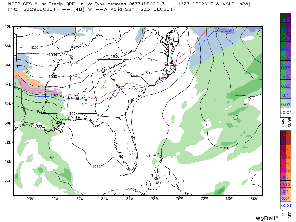
At daybreak on Sunday, moisture including some sleet and freezing rain will be located to our west over Mississippi, Arkansas, and Louisiana. That moisture will start to move into the southwestern and western parts of Alabama soon after, and by noon locations in Sumter, Greene, Hale, Perry, Dallas, and Marengo counties will be getting either sleet or freezing rain. At that point, temperatures will be below the freezing point and some light accumulations could occur as all precipitation that falls will be light in nature.
As we move into the evening hours at 6:00 PM, much of the activity has moved out of Central Alabama and into the southern parts of the state. There may be a few lingering sleet pellets falling in the southern parts of Sumter, Marengo, and Dallas counties, but at this point, the accumulation threat should have ended. There is the possibility for some travel issues in the counties mentioned, especially on bridges and overpasses, and on the lesser traveled roads.
By the time we ring in the New Year at midnight, all shower activity will have moved to the Gulf Coast and everything will have transitioned into rain by that time. All of Central Alabama will be well below freezing at this time, so any leftover moisture on the ground will probably freeze and cause some icy travel.
Bottom line… Even if you don’t receive moisture, the GFS is painting temperatures in the lower to mid-30s for highs, but those will be quickly dropping into the lower to mid-20s by midnight, and into the upper teens to the lower 20s by sunrise. Wind chill will become a big factor as winds will be increasing throughout the day, up to 15 MPH, causing those values to be in the single digits.
European (12z)
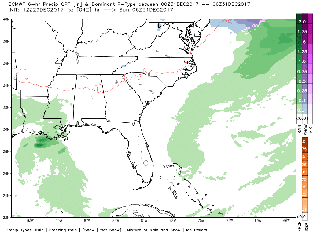
This model run starts off relatively similar with rain over the southwestern parts of Mississippi and back into Louisiana at 12:00 AM Sunday. When we get to sunrise, most of the moisture will still be located in Mississippi and westward, but some shower activity will be moving into the southwestern parts of Alabama. No wintry precipitation at this point, but temperatures will be below freezing north of the I-20 corridor.
When we get to noon, much of South Alabama will have some shower activity, but the bulk of the sleet and light snow will be back into Central Mississippi and northern Louisiana. This activity will be north of I-59 for those heading to New Orleans, so no travel problems so far with this solution.
As we move ahead to 6:00 PM Sunday, much of the shower activity will have moved farther south, and any wintry precipitation will have come to an end. With this solution, the freezing line will be just north of I-20 and north of that will be below freezing. As we reach the midnight hour and ringing in the New Year, all of Central Alabama will be dry and below freezing.
Bottom line… This solution is keeping Central Alabama from having any major travel issues, even though a few slick spots on bridges and elevated surfaces could be possible. By 12:00 AM Monday, temperatures will be down in the upper teens to the mid-20s, and winds will be out of the north at 10-15 MPH. Wind chill values will be down into the single digits. Lows will bottom out in the mid-teens to the lower 20s by sunrise.
NAM-3k (12z)
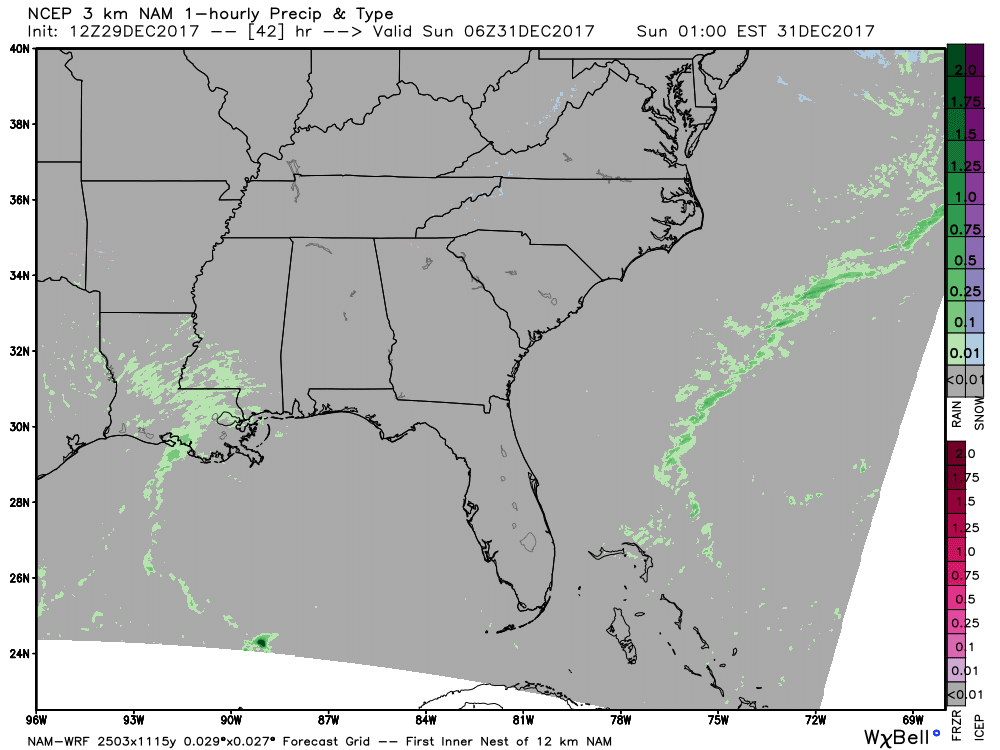
Scattered showers will start to move into the western portions of Central Alabama just before sunrise on Sunday morning, and by 8:00 AM much of western and southwestern Alabama will have some scattered shower activity with some sleet mixed in on the northern periphery.
By the time we reach the noon hour, much of the activity will have moved into the southern half of the state. Some sleet will be possible across portions of Sumter, Greene, Hale, Perry, and Bibb counties. Temperatures at that time will be below freezing for those locations and north, so light accumtravelingill be possible in those counties mentioned, especially on bridges and elevated surfaces. South of that, temperatures will be above freezing and scattered showers are expected.
At the 6:00 PM hour, nearly all shower activity will be out of the state with the exception of the extreme southeastern corner. Temperatures will be in the mid-20s to the mid-30s throughout Central Alabama at that point, and expected to drop into the upper teens to the mid-20s for the overnight lows. Winds will be out of the north at 10-15 MPH, forcing the wind chill values in the single digits to the lower teens.
With All Of That Being Said…

There could be some travel issues for those travelling to New Orleans for the big Sugar Bowl matchup between Alabama and Clemson. It would be best if you headed out before Sunday or wait until Monday morning to take your trip. I-20/59 may have icy spots on the bridges and overpasses, so if you travel on Sunday, please use extreme caution.
For those heading to Atlanta for Auburn’s matchup with UCF in the Peach Bowl, I don’t believe with these solutions that travel will be an issue. It will be cold and quite breezy, but icing on the roadways shouldn’t be a factor.
If you are staying at home to watch the games on Monday, temperatures will be really cold and wind chills even lower. Highs will be in the upper 20s to the upper 30s throughout Central Alabama, with wind chill values about 10 to 15 degrees colder. Lows throughout the area on early Tuesday morning will be in the lower teens to the lower 20s throughout the area, and wind chill values will be in the lower single digits to the lower teens. With this bitter cold, remember the 4 P’s… People… Pets… Plants… Pipes.
Category: ALL POSTS, Winter Weather
About the Author (Author Profile)
Scott Martin is an operational meteorologist, professional graphic artist, musician, husband, and father. Not only is Scott a member of the National Weather Association, but he is also the Central Alabama Chapter of the NWA president. Scott is also the co-founder of Racecast Weather, which provides forecasts for many racing series across the USA. He also supplies forecasts for the BassMaster Elite Series events including the BassMaster Classic.Subscribe
If you enjoyed this article, subscribe to receive more just like it.


