A Quick Check On Our Weather Situation At 2:45 AM
RADAR CHECH AT 2:45 AM
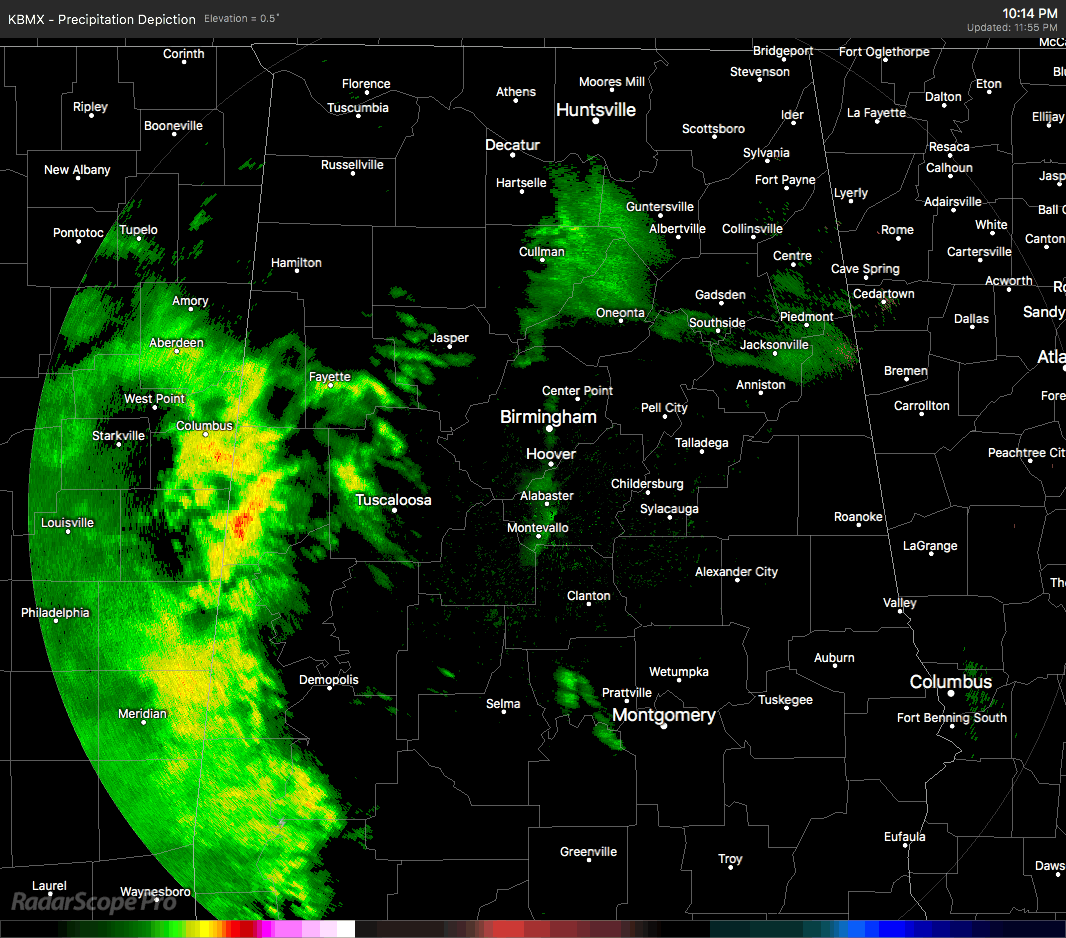
Rain is just now really pushing over the I-65 corridor for much of North and Central Alabama, with a lot of moisture on the very leading edge evaporating before hitting the ground. There may be a few sleet pellets up in the extreme northeastern corner of the state, especially near Mentone and Little River Canyon. The good news is that we have not had any reports of icing or slick spots on the roadways at this point. Temperatures are also ranging from the mid-30s to the lower 40s throughout North and Central Alabama at this point, with the exception of Fort Payne at 32 degrees as the cold spot.
WINTER WEATHER ADVISORY
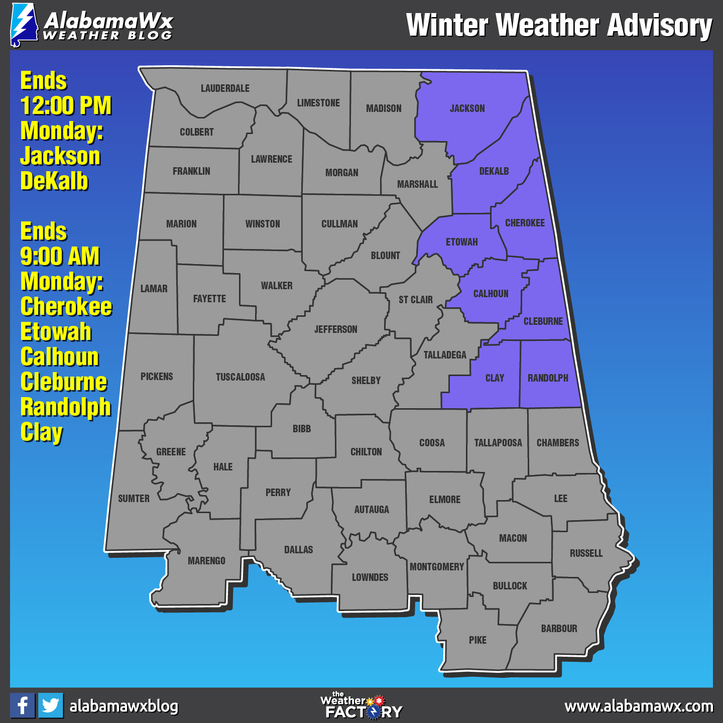
The NWS offices in Birmingham and Huntsville have issued Winter Weather Advisories for several counties in North/Central Alabama for Monday morning. NWS Birmingham has Calhoun, Cherokee, Clay, Cleburne, Etowah, and Randolph counties under a Winter Weather Advisory until 9:00 AM this morning, while NWS Huntsville has Jackson and Dekalb counties under a Winter Weather Advisory until 12:00 PM this afternoon.
A wedge of colder air is trying to work into the northeastern quarter of the state this morning, and this could allow for freezing rain to accumulate on elevated surfaces such as bridges, trees, and power lines for a brief period. Temperatures are expected to quickly rise above freezing by 9:00 AM in the NWS Birmingham advisory counties, and by noon for the Huntsville advisory counties.
Once we reach the noon hour, everything for the remainder of the day will be rain, and we could see rainfall totals approaching 1.25 inches in the western locations of Central Alabama. Afternoon highs will top out in the lower 40s to the lower 50s from north to south. Rain chances throughout the area should diminish greatly by tonight, with a few scattered showers lingering in the southern parts of Central Alabama after midnight.
TRAVELING TO ATLANTA FOR THE CHAMPIONSHIP GAME
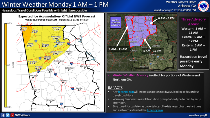
Freezing rain is forecast for the northern parts of Georgia, including the Atlanta metropolitan area. A Winter Weather Advisory is in effect for a good bit of North Georgia throughout the morning and into the early afternoon hours. It would be best to leave out later to give an opportunity for any icy spots to melt away as temperatures will slowly climb into the upper 30s to near 40 degrees. Kickoff is not until 8:17 PM EST, so you will have plenty of time to get there… just take your time and be safe. Crews have been working during the late night and overnight hours salt-brining the highways, so hopefully, the impact will be very minimal.
Category: Alabama's Weather, ALL POSTS
About the Author (Author Profile)
Scott Martin is an operational meteorologist, professional graphic artist, musician, husband, and father. Not only is Scott a member of the National Weather Association, but he is also the Central Alabama Chapter of the NWA president. Scott is also the co-founder of Racecast Weather, which provides forecasts for many racing series across the USA. He also supplies forecasts for the BassMaster Elite Series events including the BassMaster Classic.Subscribe
If you enjoyed this article, subscribe to receive more just like it.


