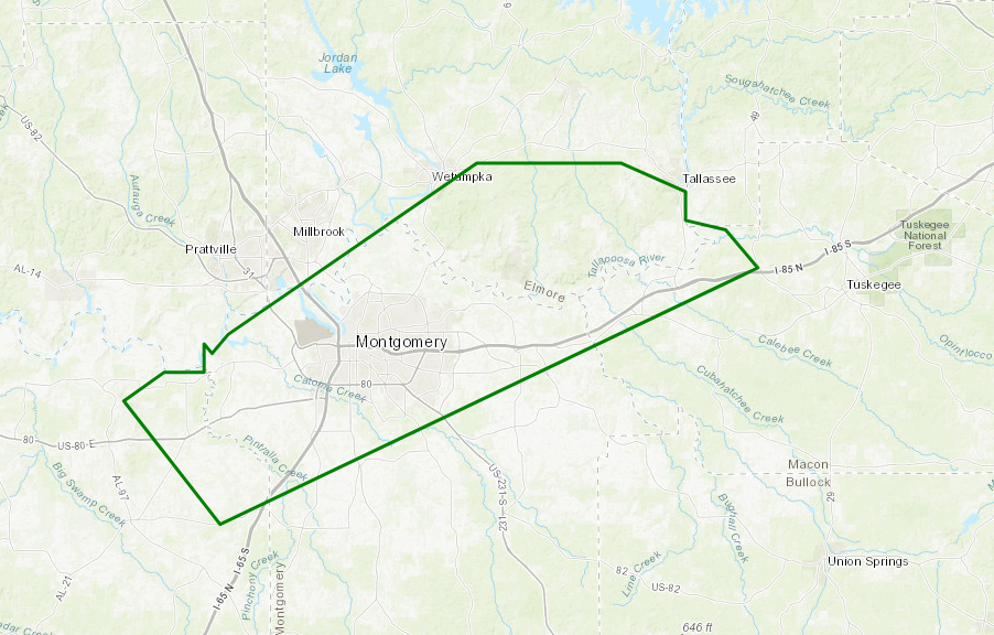
Areal Flood Advisory Issued for Parts of Elmore, Lowndes, Macon, & Montgomery Counties Until 7:30 PM
Flood Advisory
National Weather Service Birmingham AL
532 PM CST MON JAN 22 2018
ALC051-085-087-101-230130-
/O.NEW.KBMX.FA.Y.0002.180122T2332Z-180123T0130Z/
/00000.N.ER.000000T0000Z.000000T0000Z.000000T0000Z.OO/
Elmore AL-Lowndes AL-Macon AL-Montgomery AL-
532 PM CST MON JAN 22 2018
The National Weather Service in Birmingham has issued a
* Urban and Small Stream Flood Advisory for…
Southeastern Elmore County in east central Alabama…
Northeastern Lowndes County in south central Alabama…
West central Macon County in southeastern Alabama…
Northern Montgomery County in south central Alabama…
* Until 730 PM CST
* At 531 PM CST, Doppler radar and automated rain gauges indicated
heavy rain due to thunderstorms. This will cause urban and small
stream flooding in the advisory area. Up to three inches of rain
have already fallen.
* Some locations that will experience flooding include…
Montgomery, Wetumpka, Tallassee, Milstead, Shorter, Franklin,
Montgomery Zoo, Boylston, Hyundai Motors Of Alabama, Auburn
University In Montgomery, Bob Woodruff Lake, Woodcrest, Emerald
Mountain, Maxwell Air Force Base, Waugh, Lagoon Park, Hunter,
Alabama State University, Hope Hull and Dannelly Field.
Additional rainfall of one to two inches is expected over the area.
This additional rain will result in minor flooding.
Category: Alabama's Weather, ALL POSTS
About the Author (Author Profile)
Scott Martin is an operational meteorologist, professional graphic artist, musician, husband, and father. Not only is Scott a member of the National Weather Association, but he is also the Central Alabama Chapter of the NWA president. Scott is also the co-founder of Racecast Weather, which provides forecasts for many racing series across the USA. He also supplies forecasts for the BassMaster Elite Series events including the BassMaster Classic.Subscribe
If you enjoyed this article, subscribe to receive more just like it.


