Nice For Most At Midday, Showers And Storms For The Northwestern Parts
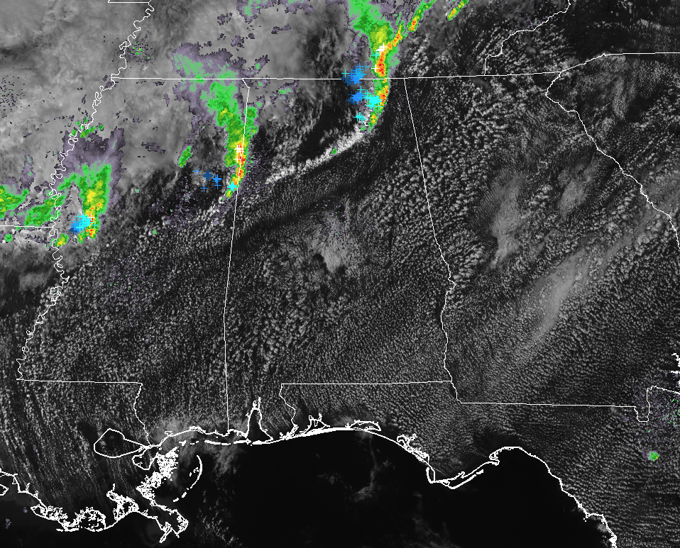
RADAR CHECK AT 12:35 PM
We have partly cloudy skies for much of Central Alabama at this point, but we have more showers and storms pushing into the northwestern parts of the area. Moderate to heavy rain is now falling over Detroit to Sulligent in Lamar County, and will soon be making its way into Vernon and Hamilton. Temperatures at this time are running in the lower 70s in the northwest to the mid-80s in the southeast. Birmingham was at 81 degrees, already tieing the record high set back in 1897. Looks like the Donna Reed animated GIF will be brought out again this evening for a record temperature report.
WEATHER FOR THE REST OF THE DAY
Looking at the latest HRRR simulated radar solution, the best chance of showers and storms will remain over Marion, Winston, Lamar, Fayette, and Walker counties throughout the remainder of the afternoon hours. A few showers could make it over into Cullman, Blount, and Jefferson counties later this afternoon, but I believe these will dissipates as the frontal boundary will start to push northward and back out of the state as a warm front. For the remainder of the area, skies will remain partly cloudy. Afternoon highs will top out in the upper 70s to the mid-80s, and a few old record highs may be either tied or broken. We’ll have to wait for the report from NWS Birmingham later this evening. For tonight, clouds will be on the increase and some patchy fog developing is possible throughout the area. Overnight lows will be in the upper 50s to the lower 60s.
FRIDAY’S WEATHER
I wish the weather for my 41st birthday would be a little better, as there is a small risk of scattered showers and thunderstorms over the western half of the area. Skies will be partly cloudy and warm temperatures will prevail as the ridge continues to hold station over the southeast. Afternoon highs will top out in the lower to mid-80s throughout the area, but I believe record highs may not be broken for the first time this week… we’ll see. That small risk of showers and a few thunderstorms will move over most of the area for Friday night, with the higher risks coming over the northwestern parts of the area, while much of the southeastern parts of the area will remain dry. Overnight lows will be in the lower to mid-60s.
BEACH FORECAST CENTER
Is it warm or cold at the beach today? Will it rain in two days? Get the latest forecast for the beaches from Fort Morgan to Panama City on our Beach Forecast Center page. There, you can select the forecast of the region that you are interested in.
WEATHERBRAINS
Don’t forget you can listen to our weekly 90 minute netcast anytime on the web at WeatherBrains.com or on iTunes. This is the show all about weather featuring many familiar voices, including the meteorologists at ABC 33/40.
ON THIS DAY IN WEATHER HISTORY
1990 – Thunderstorms developing along and ahead of a cold front produced severe weather from southern Mississippi to North Carolina. One thunderstorm spawned a tornado just prior to dawn which touched down near Opp AL injuring ten persons and causing half a million dollars damage. Thunderstorm winds injured four persons south of Troy AL, and five people at Columbus GA. Thunderstorm winds gusted to 76 mph at Dothan AL.
Category: Alabama's Weather, ALL POSTS
About the Author (Author Profile)
Scott Martin is an operational meteorologist, professional graphic artist, musician, husband, and father. Not only is Scott a member of the National Weather Association, but he is also the Central Alabama Chapter of the NWA president. Scott is also the co-founder of Racecast Weather, which provides forecasts for many racing series across the USA. He also supplies forecasts for the BassMaster Elite Series events including the BassMaster Classic.Subscribe
If you enjoyed this article, subscribe to receive more just like it.


