Sun Filled Weekend Ahead
**No afternoon Weather Xtreme video today**
A CHANCE TO DRY OUT: Dry air will cover Alabama through Sunday, meaning sunny pleasant days and clear chilly nights. Highs will be in the mid 60s tomorrow, followed by upper 60s Sunday. Early morning lows will be in the 30-35 degree range with potential for some frost… colder pockets will see upper 20s.
NEXT WEEK: Clouds increase Monday ahead of a cold front, and a band of organized showers and storms will pass through the state Monday night and early Tuesday. At this point, it looks like the best chance of rain will come from 6:00 p.m. Monday through 9:00 a.m. Tuesday; rain amounts of 1/2 to 1 inch are likely. There is very little surface based instability, so for now the threat of severe weather looks low.
A fairly deep upper trough will set up over the eastern third of the nation over the latter half of next week, pulling down very cool air for March. Highs drop into the 50s Wednesday and Thursday; some North Alabama communities could hold in the 40s on one or both of these days. A freeze seems likely by Thursday and Friday morning with lows in the 26-32 degree range.
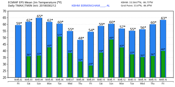
Medium range data suggests the next chance of rain will come late in the following weekend, around Sunday March 11.
ON THIS DATE IN 2012: A multiple-vortex EF-2 tornado crossed Lake Martin near the beginning of its path before passing near Jackson’s Gap, Eagle Creek, and Trammel Crossroads. Several homes sustained significant damage, and multiple mobile homes were completely destroyed. One mobile home frame was wrapped completely around a tree trunk. Thousands of trees were snapped and uprooted along the path… one was killed and two other people were injured.
The same day an EF-3 tornado moved through parts of Limestone and Madison Counties… it first moved through multiple subdivisions near Athens, with roofs torn off homes, windows and garage doors blown out, exterior walls damaged, and garages collapsed. The tornado then caused major roof and exterior wall damage to homes in and around Harvest. Homes at the north edge of Meridianville had their roofs torn off, a metal shed was severely damaged, a concrete power pole was snapped, and buildings at Meridianville Middle School sustained roof damage. The most intense damage occurred near Hazel Green, where several homes had roofs torn off and walls collapsed, and three were reduced to rubble.
WEATHER BRAINS: Don’t forget you can listen to our weekly 90 minute netcast anytime on the web, or on iTunes. This is the show all about weather featuring many familiar voices, including our meteorologists here at ABC 33/40.
CONNECT: You can find me on all of the major social networks…
Facebook
Twitter
Google Plus
Instagram
Pinterest
Snapchat: spannwx
I enjoyed seeing students today at N.E. Miles Jewish Day School in Birmingham… and also at Montevallo Elementary… be looking for them on the Pepsi KIDCAM today at 5:00 and 6:00 on ABC 33/40 News! My next Weather Xtreme video will be posted here Monday morning by 7:00 a.m… Brian Peters will have the video updates tomorrow and Sunday. Enjoy the weekend!
Category: Alabama's Weather, ALL POSTS
About the Author (Author Profile)
James Spann is one of the most recognized and trusted television meteorologists in the industry. He holds the AMS CCM designation and television seals from the AMS and NWA. He is a past winner of the Broadcast Meteorologist of the Year from both professional organizations.Subscribe
If you enjoyed this article, subscribe to receive more just like it.


