A Quick Check On Central Alabama’s Weather At 1:45 PM
Radar Check


At 1:40 PM, radar was showing showers over on the western parts of the state, while the eastern half is mainly staying dry at this point. Heavier showers were currently over the extreme southern parts of Lamar and Fayette counties, and stretching down into Pickens County. More showers are down in the extreme southwestern parts of the area, but those are not as heavy at this point. Temperatures are currently ranging from the lower 60s to the lower 70s throughout the area. Birmingham was at 66 degrees.
Weather For The Remainder Of Your Friday

Rain is having trouble expanding east at this point due to drier air over much of Central Alabama, but the push of moisture will eventually win out and all of Central Alabama will have rain by this evening. Some thunder may be possible before sunset but highly unlikely at this point. The good news is that all of the activity that will be moving in from Mississippi will be weakening and the Storm Prediction Center is keeping any risk of severe storms west of Alabama. Afternoon highs will get up into the upper 60s to the mid-70s. Rain and thunderstorms will be likely over much of Central Alabama throughout the evening and overnight hours, with a little less of a chance south of I-85 and east of I-65 in the southeastern parts of the area. Overnight lows will bottom out in the mid to upper 50s. Rainfall amounts by sunrise on Saturday morning will range from less than 0.10 inches in the east to as much as 1.00 inches in the west.
Scattered Showers To Start Your Saturday, But Drying Out Some In The Afternoon

Scattered showers and a few thunderstorms will continue to move through the area during the morning hours, but much of Central Alabama may have a good bit of the afternoon and evening hours dry. Clouds will thin out some as well, becoming partly cloudy by the afternoon. The only problem is that there will be a cold front starting to move into Central Alabama from the north, and any sunshine may help in the development of showers and thunderstorms for later into the evening and overnight hours. No organized severe storms are expected, and there will only be a small risk for showers and storms at this point. Afternoon highs will be in the mid-70s to the lower 80s with lows dropping back down into the upper 40s to the upper 50s.
A Quick Heads Up On Monday’s Weather

At this point, it appears that Monday will be a pretty active weather day in Central Alabama. The SPC has already outlined all of Central Alabama, along with most of the rest of the state, much of the southern half of Georgia, and the northwestern quarter of Mississippi in a 15% severe weather outlook on their day 4 map. We’ll need to watch this situation very closely as we are in the middle of our prime severe weather season.
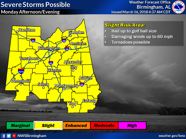
As you can see, NWS Birmingham has already put up their graphic showing the main threats for Monday afternoon and into the evening. Damaging winds up to 60 MPH, damaging hail up to golf-ball size, and a few tornadoes will all be possible. Now is the time to go over your severe weather safety plans and have your supplies ready to go just in case your location goes under a warning. Make sure your batteries are fresh in your NOAA Weather Radio and in your flashlights and have your smartphones fully charged. It’s always better to be safe than sorry in these situations. We’ll keep you updated throughout the weekend.
Beach Forecast Center
Don’t you wish you were there, already? Soaking up the rays and wiggling your toes in the sand? Get the latest forecast for the beaches from Fort Morgan to Panama City on our Beach Forecast Center page. There, you can select the forecast of the region that you are interested in.
WeatherBrains
Don’t forget you can listen to our weekly 90 minute netcast anytime on the web at WeatherBrains.com or on iTunes. This is the show all about weather featuring many familiar voices, including the meteorologists at ABC 33/40.
E-Forecast
Get the AlabamaWx Weather Blog’s Seven-Day Forecast delivered directly to your inbox by email twice daily. It is the most detailed weather forecast available in Central Alabama. Subscribe here… It’s free!
Advertise With Us
Don’t miss out! We have enjoyed nearly 3.3 MILLION page views on AlabamaWx.com since the start of 2018. We can customize a creative, flexible and affordable package that will suit your organization’s needs. Contact Bill Murray at (205) 687-0782.
On This Day In Weather History
1990 – Thunderstorms developing ahead of a cold front produced large hail and damaging winds from northwest Florida to western South Carolina. Thunderstorm winds gusted to 75 mph at Floridatown FL. Sixteen cities across the northeastern quarter of the nation reported record high temperatures for the date. The afternoon high of 78 degrees at Burlington VT smashed their previous record for the date by 23 degrees. New York City reported a record high of 82 degrees.
Category: Alabama's Weather, ALL POSTS
About the Author (Author Profile)
Scott Martin is an operational meteorologist, professional graphic artist, musician, husband, and father. Not only is Scott a member of the National Weather Association, but he is also the Central Alabama Chapter of the NWA president. Scott is also the co-founder of Racecast Weather, which provides forecasts for many racing series across the USA. He also supplies forecasts for the BassMaster Elite Series events including the BassMaster Classic.Subscribe
If you enjoyed this article, subscribe to receive more just like it.


