Tornado Warning Expired For Parts Of Madison And Lincoln (TN) Counties
…THE TORNADO WARNING FOR NORTHEASTERN MADISON AND SOUTHEASTERN
LINCOLN COUNTIES WILL EXPIRE AT 730 PM CDT…
The storm which prompted the warning has weakened below severe
limits, and no longer appears capable of producing a tornado.
Therefore the warning will be allowed to expire.
A tornado watch remains in effect until 1100 PM CDT for north central
and northeastern Alabama…and Middle Tennessee.
Remember, a Severe Thunderstorm Warning still remains in effect for
northern Madison, northwestern Jackson, southeastern Lincoln, and
southwestern Franklin Counties.
LAT…LON 3499 8632 3499 8631 3498 8631 3497 8629
3494 8628 3495 8629 3493 8632 3491 8631
3488 8634 3490 8660 3508 8660 3509 8632
TIME…MOT…LOC 0021Z 270DEG 34KT 3496 8639
Tornado Warning Continues For Parts Of Madison And Lincoln (TN) Counties Until 12:30AM
Mar 19th @ 6:56 pm

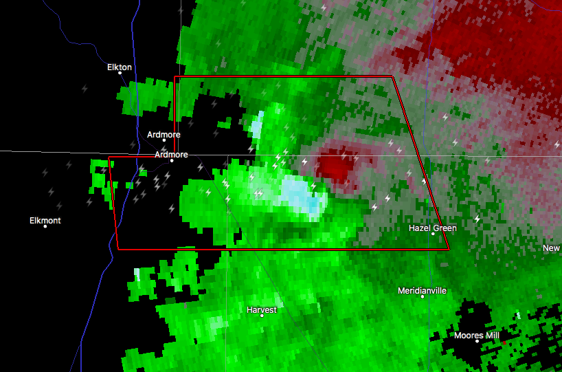
…A TORNADO WARNING REMAINS IN EFFECT UNTIL 730 PM CDT FOR NORTHEASTERN MADISON AND SOUTHEASTERN LINCOLN COUNTIES… At 707 PM CDT, a severe thunderstorm capable of producing a tornado was located over Hazel Green, or 7 miles north of Meridianville, moving east at 40 mph.
HAZARD…Tornado and quarter size hail.
SOURCE…Radar indicated rotation.
IMPACT…Flying debris will be dangerous to those caught without shelter. Mobile homes will be damaged or destroyed. Damage to roofs, windows, and vehicles will occur. Tree damage is likely. This dangerous storm will be near… New Market around 720 PM CDT. Other locations impacted by this tornadic thunderstorm include Plevna, Flintville, Elora, Belleview and Fisk.
Tornado Warning Issued For Parts Of Madison And Lincoln (TN) Counties Until 7:30 PM
Mar 19th @ 6:56 pm

The National Weather Service in Huntsville Alabama has issued a
* Tornado Warning for…
Northern Madison County in north central Alabama…
Southern Lincoln County in Middle Tennessee…
* Until 730 PM CDT
* At 653 PM CDT, a severe thunderstorm capable of producing a tornado was located 7 miles north of Harvest, or 10 miles northwest of
Meridianville, moving east at 40 mph.
HAZARD…Tornado and quarter size hail.
SOURCE…Radar indicated rotation. At 643 PM, multiple structures were damaged in Ardmore. This storm has a history of producing damage.
IMPACT…Flying debris will be dangerous to those caught without shelter. Mobile homes will be damaged or destroyed.
Damage to roofs, windows, and vehicles will occur. Tree damage is likely.
* This dangerous storm will be near…
Meridianville and Hazel Green around 705 PM CDT.
Moores Mill around 710 PM CDT.
New Market around 720 PM CDT.
Other locations impacted by this tornadic thunderstorm include
Elkwood, Plevna, Flintville, Blanche and Elora.
Category: ALL POSTS
About the Author (Author Profile)
Subscribe
If you enjoyed this article, subscribe to receive more just like it.


