

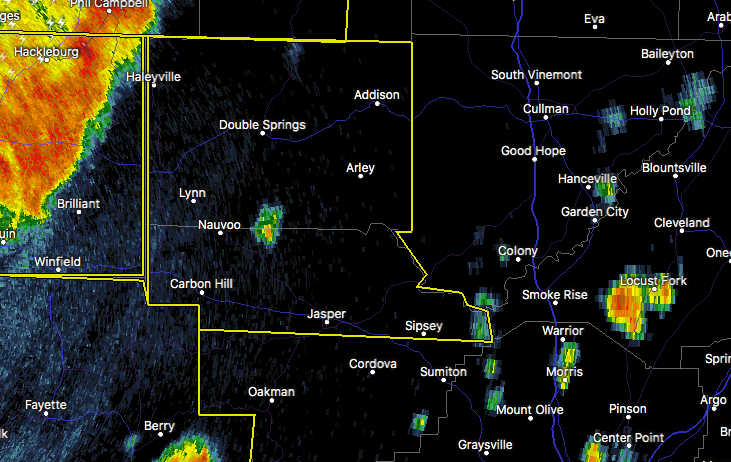
Severe Thunderstorm Warning For Parts of Walker & Winston Counties Until 10:45 PM
The National Weather Service in Birmingham has issued a
* Severe Thunderstorm Warning for…
Northern Walker County in central Alabama…
Winston County in northwestern Alabama…
* Until 1045 PM CDT
* At 950 PM CDT, severe thunderstorms were located along a line
extending from near Guin to near Phil Campbell, moving east at 60
mph.
HAZARD…70 mph wind gusts.
SOURCE…Radar indicated.
IMPACT…Expect considerable tree damage. Damage is likely to
mobile homes, roofs, and outbuildings.
* Locations impacted include…
Jasper, Haleyville, Carbon Hill, Lynn, Arley, Double Springs,
Addison, Sipsey, Kansas, Nauvoo, Eldridge, Curry, Houston
Recreational Area, Camp McDowell, Smith Dam, Nesmith, Ashbank,
Brushy Lake, Poplar Springs and Ashridge.
Category: Alabama's Weather, ALL POSTS
About the Author (Author Profile)
Scott Martin is an operational meteorologist, professional graphic artist, musician, husband, and father. Not only is Scott a member of the National Weather Association, but he is also the Central Alabama Chapter of the NWA president. Scott is also the co-founder of Racecast Weather, which provides forecasts for many racing series across the USA. He also supplies forecasts for the BassMaster Elite Series events including the BassMaster Classic.Subscribe
If you enjoyed this article, subscribe to receive more just like it.


