A Very Nice & Warm Midday, Even Warmer Tomorrow
With a surface high located on the Carolina coastline, we have a south-southeasterly flow across Central Alabama providing us with warmer conditions from what we experienced just one day ago. We have sunny skies at the 11:30 AM mark on this fabulous Thursday morning, and temperatures are running in the lower 70s in the north to the upper 70s in the south. Birmingham was sitting at 75 degrees.
For the afternoon and early evening hours, we’ll continue to have sunny skies and warm temperatures with a breeze at times. Afternoon highs will reach the upper 70s to the lower 80s throughout Central Alabama from north to south, and winds will be out of the south averaging 10-15 MPH. For this evening and throughout the overnight hours, we’ll have a few clouds roll in from the west and block out a few stars in the western parts of the area, but the rest of the area will remain clear. Lows will only dip down into the lower to mid-50s.
Friday’s weather will continue to be really nice throughout Central Alabama, with mostly clear skies and even warmer temperatures throughout the day. Highs will top out in the upper 70s to the mid-80s from north to south. There will be a breeze to help cool you off a little if you are outside, averaging 10-15 MPH out of the south. It will also feel just a little more humid as more moisture will be pulled up into the area from the Gulf of Mexico, but rain will not affect the area until Saturday. Friday night will be a great evening with partly cloudy skies and mild temperatures, only dropping into the mid to upper 60s by 10:00 PM. Overnight lows will be in the lower to mid-60s.
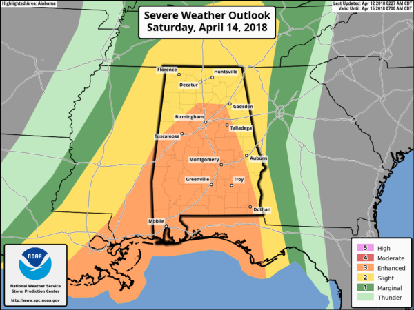
At this point of the day, we are still too far out from the high-resolution models to paint a picture for our threat of strong to severe storms for Saturday. According to the 12z run of the NAM-3k, there will be two separate squall lines to affect the area, with the first moving into the western parts of Central Alabama around 8:00 AM-10:00 AM. There will be a modest amount of instability with a good bit of low-level helicity at that time. Significant Tornado Parameter values will be running at 1.0 or less, so this paints that strong to severe storms will be possible with the main threat coming from damaging winds, with a small isolated tornado threat. That first line will lose strength as it moves eastward through the northern half of Central Alabama, and the severe threat should be over by 2:00 PM.
A second squall line will move in much later into the evening hours, around 6:00 PM-8:00 PM. The strong to severe storm threat will mainly be for locations in Pickens, Greene, Sumter, and Marengo counties. At that time, damaging winds and a few tornadoes will be possible for those locations. This model run only goes out to 7:00 PM on Saturday, so we’ll have more detailed information when the 18z comes out later today. As James stated earlier, the window for strong to severe storms in the southern half of Central Alabama could possibly last until 3:00 AM Sunday. Keep checking back on the blog throughout the rest of today and Friday for updates.
On This Day In Weather History
1927 – A tornado wiped out the town of Rock Springs, TX, killing 72 persons and causing 1.2 million dollars damage. The tornado, more than one mile in width, destroyed 235 of 247 buildings, leaving no trace of lumber or contents in many cases. Many survivors were bruised by large hail which fell after the passage of the tornado.
Beach Forecast Center
Don’t you wish you were there, already? Soaking up the rays and wiggling your toes in the sand? Get the latest weather and rip current forecasts for the beaches from Fort Morgan to Panama City on our Beach Forecast Center page. There, you can select the forecast of the region that you are interested in.
WeatherBrains
Don’t forget you can listen to our weekly 90 minute netcast anytime on the web at WeatherBrains.com or on iTunes. This is the show all about weather featuring many familiar voices, including the meteorologists at ABC 33/40.
E-Forecast
Get the AlabamaWx Weather Blog’s Seven-Day Forecast delivered directly to your inbox by email twice daily. It is the most detailed weather forecast available in Central Alabama. Subscribe here… It’s free!
Advertise With Us
Don’t miss out! We have enjoyed more than 6.7 MILLION page views on AlabamaWx.com since the start of 2018. We can customize a creative, flexible and affordable package that will suit your organization’s needs. Contact Bill Murray at (205) 687-0782.
Category: Alabama's Weather, ALL POSTS


