The NWS Birmingham’s Take on the Threat, By Matt Grantham
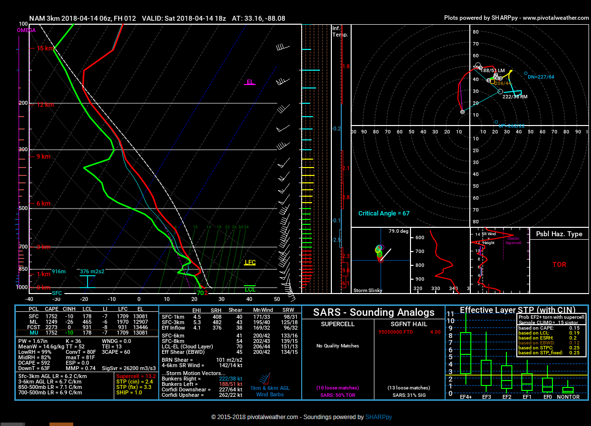
Model generated sounding for 1 p.m. over West Alabama showing favorable conditions for tornadoes
NWS Forecaster Matt Grantham has penned the short term portion of the Area Forecast Discussion this morning and it tells the story well. I thought I would share it directly.
.SHORT TERM…
Today through Sunday.
Confidence continues to increase in the threat for severe storms
this afternoon into tonight. Models have been trending slightly
slower and more toward a neutral and eventually negative tilt with
the upper-level trough as it moves toward the Mississippi River
Valley. These small changes should result in lower surface pressures
along the cold front with stronger backing of surface winds as a
QLCS approaches from the west. The slower timing should also allow
SBCAPE values to increase into the range of 1500-2500 J/kg across
the western half of Alabama before storms arrive. A QLCS with a
sizable damaging wind and tornado threat appears likely particularly
west of a line from Gadsden to Montgomery. A couple of strong
tornadoes (EF2-EF3) cannot be ruled out along and northwest of a
line from Demopolis to Birmingham, where forecast hodographs
indicate 0-1km shear of 30-40kt with clockwise curvature. This
potential may be associated with a couple of isolated supercells
ahead of or embedded within the QLCS. The threat should gradually
diminish across our eastern areas as the convective line loses
forward momentum and moves into weaker instability during the
evening and overnight hours. The severe threat will probably end
around 2 AM in our southeastern counties.
The passage of a cold front will bring cooler conditions for Sunday.
Rainfall should exit into Georgia during the morning hours, leading
to a somewhat breezy and cool afternoon.
87/Grantham
Category: Alabama's Weather, ALL POSTS
About the Author (Author Profile)
Bill Murray is the President of The Weather Factory. He is the site's official weather historian and a weekend forecaster. He also anchors the site's severe weather coverage. Bill Murray is the proud holder of National Weather Association Digital Seal #0001 @wxhistorianSubscribe
If you enjoyed this article, subscribe to receive more just like it.


