

Strong Storms About to Enter West Alabama at this Time
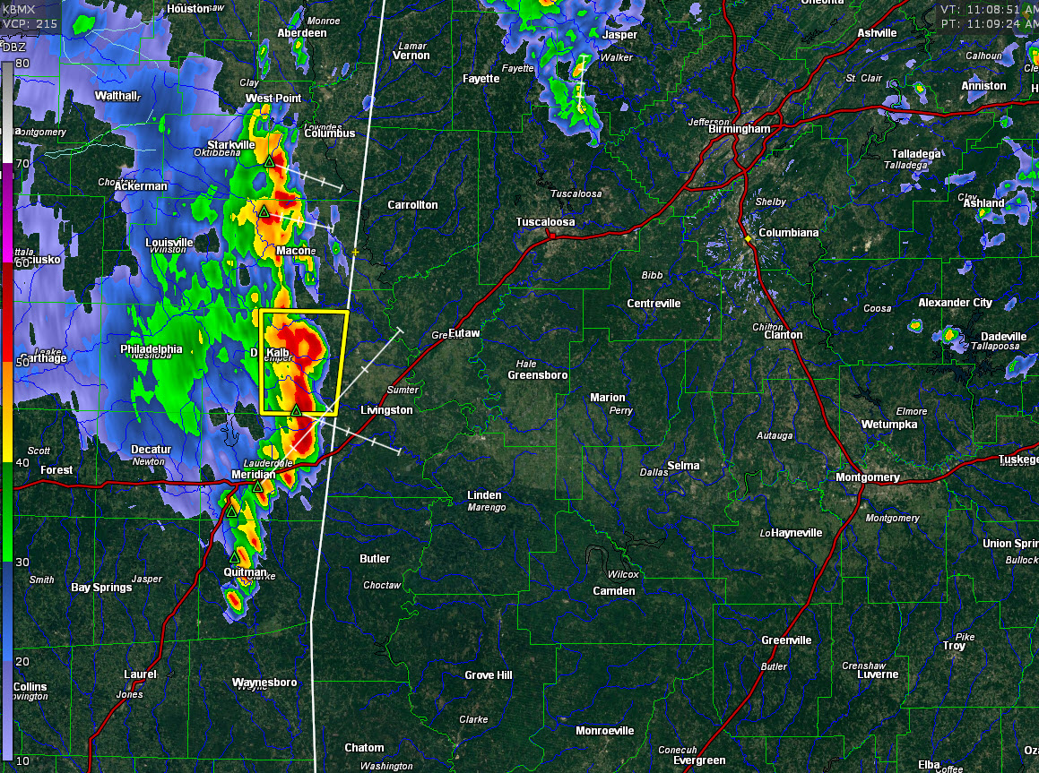
A line of storms is about to exit eastern Mississippi into western Alabama at this hour.
It is moving generally east at 15-20 mph.
It will impact areas from southern Lamar and Fayette Counties through Pickens, Tuscaloosa, Sumter, Greene, Hale and northern Marengo Counties.
60 mph wind gusts and quarter-sized hail is possible with the strongest storm, which will affect Sumter County.
A severe thunderstorm warning was just issued for Kemper County, Mississippi, which is across the border from Sumter County.
It will be into Sumter County before 11:30 and into Pickens County around Noon. It shouldn’t reach Tuscaloosa before around 2 p.m. or later. They should reach Birmingham by late afternoon, probably just in time for rush hour.
The system is being picked up on the mesoscale models, but they are shear it apart and weaken it as it moves into Alabama. SO there is a good deal of uncertainty about the system’s fate as it pushes deeper into Alabama.
SKies are clear ahead of the storms over West Alabama and temperatures are climbing. It is now 79F at Tuscaloosa with a dewpoint of 68F. This is causing instabilities to rise quickly to 1,000-2,000 joules/kg over ahead of the line. East of I-65, instabilities are already in the 1,000-1,5000 joules/kg range. The storms should slowly intensify as they head east. A few damaging wind gusts and some hail is possible along with heavy rain and lightning.
Elsewhere across the state, there are scattered showers over the northern half of Alabama. There is a concentration over Marion, Winston, Fayette and Walker Counties. Other showers are scattered from Blount into DeKalb, Cherokee, Cleburne, Clay and Randolph Counties in East Alabama.
There is a little bit of lightning in the activity over Northwest Alabama.
Category: Alabama's Weather, ALL POSTS
About the Author (Author Profile)
Bill Murray is the President of The Weather Factory. He is the site's official weather historian and a weekend forecaster. He also anchors the site's severe weather coverage. Bill Murray is the proud holder of National Weather Association Digital Seal #0001 @wxhistorianSubscribe
If you enjoyed this article, subscribe to receive more just like it.


