SPC Mesoscale Discussion: Small Chance East Alabama Could See a Severe Thunderstorm Watch
The SPC just issued a mesoscale discussion about the possibility of a severe thunderstorm watch that could include eastern Alabama. The chance is still small but the HRRR supports the idea, so conditions are being monitored for the possibility.
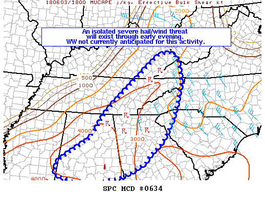 Mesoscale Discussion 0634
NWS Storm Prediction Center Norman OK
0224 PM CDT Sun Jun 03 2018
Areas affected...eastern Kentucky...eastern Tennessee...western
North Carolina...northern Georgia...much of Alabama...and a small
part of Upstate South Carolina
Concerning...Severe potential...Watch unlikely
Valid 031924Z - 032030Z
Probability of Watch Issuance...20 percent
SUMMARY...Storms developing in the discussion area are in a strongly
unstable environment and may produce damaging wind gusts and hail.
Convective trends will be monitored for a WW issuance, although the
probability of a WW is low.
DISCUSSION...Scattered convection continues to gradually deepen
along a southeastward-moving cold front and in localized areas
across northern Georgia and western North Carolina. These storms
are in a strongly unstable and weakly capped airmass, with SBCAPE
values ranging from 2000-3000 J/kg in Kentucky/Tennessee to around
4000+ J/kg in eastern Alabama. As storms continue to deepen and
realize the instability, damaging downbursts and hail will become
more likely on at least an isolated basis. Weak low-level shear and
20-30 kt northwesterly mid-level flow will foster outflow-dominant
storms, and upscale growth into clusters and small linear segments
are possible through early evening.
Convective trends will be monitored for areas of heightened severe
risk focused near any localized areas of greater convective coverage
and/or linear organization. Latest HRRR and Nam4 guidance suggest
that this threat may be highest across eastern Alabama and western
Georgia. If this scenario can materialize, a Severe Thunderstorm
Watch may be needed, although the probabilities of this occurring
are currently around 20%.
..Cook/Guyer.. 06/03/2018
   Mesoscale Discussion 0634
   NWS Storm Prediction Center Norman OK
   0224 PM CDT Sun Jun 03 2018

   Areas affected...eastern Kentucky...eastern Tennessee...western
   North Carolina...northern Georgia...much of Alabama...and a small
   part of Upstate South Carolina

   Concerning...Severe potential...Watch unlikely

   Valid 031924Z - 032030Z

   Probability of Watch Issuance...20 percent

   SUMMARY...Storms developing in the discussion area are in a strongly
   unstable environment and may produce damaging wind gusts and hail.
   Convective trends will be monitored for a WW issuance, although the
   probability of a WW is low.

   DISCUSSION...Scattered convection continues to gradually deepen
   along a southeastward-moving cold front and in localized areas
   across northern Georgia and western North Carolina.  These storms
   are in a strongly unstable and weakly capped airmass, with SBCAPE
   values ranging from 2000-3000 J/kg in Kentucky/Tennessee to around
   4000+ J/kg in eastern Alabama.  As storms continue to deepen and
   realize the instability, damaging downbursts and hail will become
   more likely on at least an isolated basis.  Weak low-level shear and
   20-30 kt northwesterly mid-level flow will foster outflow-dominant
   storms, and upscale growth into clusters and small linear segments
   are possible through early evening.

   Convective trends will be monitored for areas of heightened severe
   risk focused near any localized areas of greater convective coverage
   and/or linear organization.  Latest HRRR and Nam4 guidance suggest
   that this threat may be highest across eastern Alabama and western
   Georgia.  If this scenario can materialize, a Severe Thunderstorm
   Watch may be needed, although the probabilities of this occurring
   are currently around 20%.

..Cook/Guyer.. 06/03/2018Category: ALL POSTS
About the Author (Author Profile)
Bill Murray is the President of The Weather Factory. He is the site's official weather historian and a weekend forecaster. He also anchors the site's severe weather coverage. Bill Murray is the proud holder of National Weather Association Digital Seal #0001 @wxhistorianSubscribe
If you enjoyed this article, subscribe to receive more just like it.


