Weather Update Just After Midday; Marginal Risk Area Expands Southward
CONDITIONS ACROSS NORTH/CENTRAL ALABAMA AT 1:00 PM
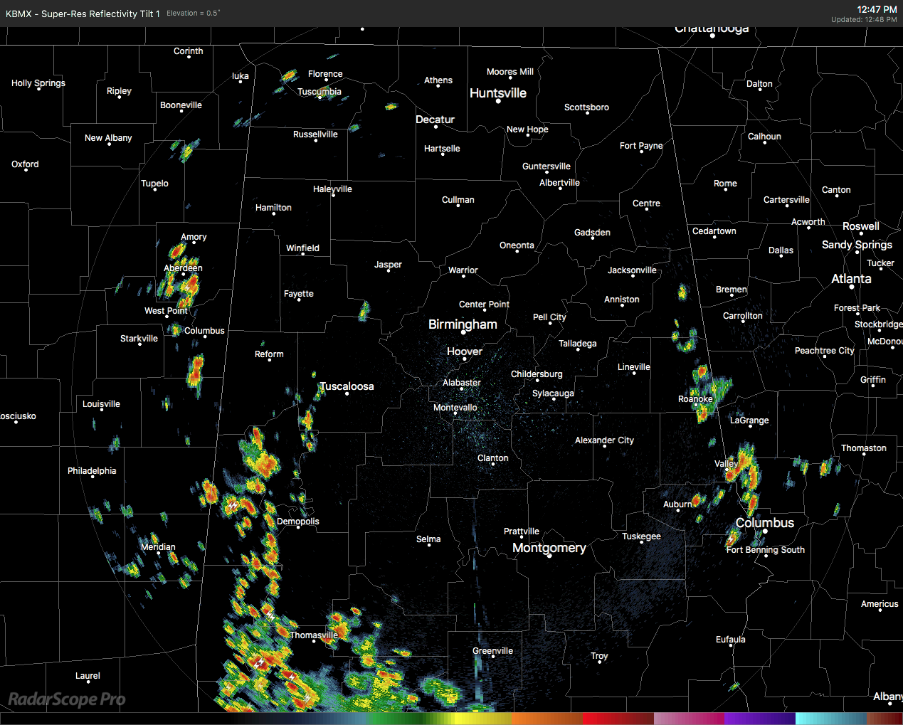
Radar has really fired up down in the southwestern parts of the state which does include showers and storms over parts of Sumter, Greene, Hale counties, along with the extreme western parts of Marengo and the southwestern parts of Tuscaloosa County. These are moving very slowly to the east-southeast.
We also have showers and storms that have developed over the extreme eastern parts of the area along the Alabama/Georgia state line, mainly stretching from the central parts of Cleburne County down to the south into northern Russell County. These are nearly stationary at this point.
Nearly the rest of North and Central Alabama is dry with the exception of a few isolated showers in the northwest corner of the state in Lauderdale, Colbert, and Lawrence counties. Temperatures are ranging in the lower 80s in the north to the mid and upper 80s in the south. Montgomery is the warm spot at 88 degrees, while the cool spot is Albertville at 77 degrees, the only reporting station in North/Central Alabama still in the 70s. Birmingham was at 82 degrees.
WEATHER FOR THE REST OF YOUR TUESDAY
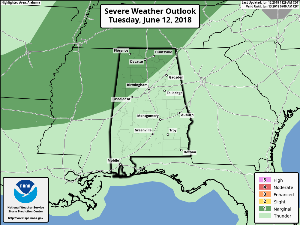
We have noticed that the Storm Prediction Center has included more of the northwestern parts of the state in the Marginal Risk for severe storms through the remainder of your Tuesday. The risk area now includes locations along and north of a line from Geiger (Sumter Co.) to Warrior (Jefferson Co.) to Henager (Dekalb Co.). Precipitable water values will be up around 2.00 inches, and combine that with a low-level zone of convergence that will try to enter the area from Georgia, this will lead to an increased chance of showers and storms throughout the area this afternoon and in to the evening hours. The higher instability values are currently located over the northwestern parts of the state nearly of to 3,500 J/kg CAPE.
Clouds will continue to increase with the heating of the day and so will the coverage of showers and thunderstorms across the area. Daytime highs will top out in the mid to upper 80s. We’ll have to watch for storms developing in the risk area as any storms in this area could be capable of damaging thunderstorm wind gusts up to 60s MPH and some small hail. A few strong storms are possible across the rest of the area, mainly with the possibility of wind gusts up to 40-50 MPH. All of these storms will include heavy downpours at times along with dangerous cloud-to-ground lightning. Get indoor immediately if you hear thunder. If you can hear thunder, you are close enough to the parent thunderstorm to be struck by lightning.
Most of the storm activity is likely to diminish by the late night hours, but a few could linger on into the overnight hours. There could be a few more showers and storms develop across the northwestern parts of the area as we near sunrise on Wednesday due to an impulse that may move through. Overnight lows will bottom out in the upper 60s to the lower 70s.
MORE STORMS LIKELY ON WEDNESDAY
A weak vorticity axis along with enhanced mid0level moisture will expand into the area on Wednesday keeping our precipitable water values at or just over 2.00 inches will enhance our rainfall chances throughout the day. Showers and storms will become likely (around 60% chance or a little higher) during the afternoon and evening hours, but storms are possible even throughout the morning. Afternoon highs will be up in the upper 80s to just at 90 degrees.
AN UPDATE ON THE TROPICS
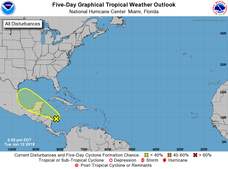
A large area of showers and thunderstorms located over the western Caribbean Sea is forecast to move westward to northwestward over Central America and the Yucatan Peninsula during the next couple of days, and little development is expected during that time due to strong upper-level winds. However, environmental conditions could become slightly more conducive for some development when the system moves into the southwestern Gulf of Mexico by the end of the week. No threat to the US at this point. The rest of the North Atlantic, Caribbean Sea, and the Gulf of Mexico is calm.
BEACH FORECAST CENTER
Get the latest weather and rip current forecasts for the beaches from Fort Morgan to Panama City on our Beach Forecast Center page. There, you can select the forecast of the region that you are interested in.
WE’RE HAVING A RECORD-BREAKING YEAR… ADVERTISE WITH US TODAY!
Don’t miss out! We have enjoyed over 10.5 MILLION page views on AlabamaWx.com since the start of 2018. We can customize a creative, flexible and affordable package that will suit your organization’s needs. Contact Bill Murray at (205) 687-0782.
E-FORECAST
Get the AlabamaWx Weather Blog’s Seven-Day Forecast delivered directly to your inbox by email twice daily. It is the most detailed weather forecast available in Central Alabama. Subscribe here… It’s free!
WEATHERBRAINS
Don’t forget you can listen to our weekly 90 minute netcast anytime on the web at WeatherBrains.com or on iTunes. This is the show all about weather featuring many familiar voices, including the meteorologists at ABC 33/40.
ON THIS DAY IN WEATHER HISTORY
1989 – Thunderstorms produced severe weather from Tennessee Valley to the Central Appalachians in the afternoon and evening, and produced severe weather in Oklahoma and Texas during the evening and night. Thunderstorms spawned ten tornadoes, and there were 164 reports of large hail and damaging winds. Thunderstorms produced wind gusts to 100 mph at Amarillo, TX, and wind gusts to 110 mph at Denton TX. Hail three inches in diameter was reported at Tucumcari NM.
Category: Alabama's Weather, ALL POSTS
About the Author (Author Profile)
Scott Martin is an operational meteorologist, professional graphic artist, musician, husband, and father. Not only is Scott a member of the National Weather Association, but he is also the Central Alabama Chapter of the NWA president. Scott is also the co-founder of Racecast Weather, which provides forecasts for many racing series across the USA. He also supplies forecasts for the BassMaster Elite Series events including the BassMaster Classic.Subscribe
If you enjoyed this article, subscribe to receive more just like it.


