

Storms Approaching The Birmingham Metropolitan Area
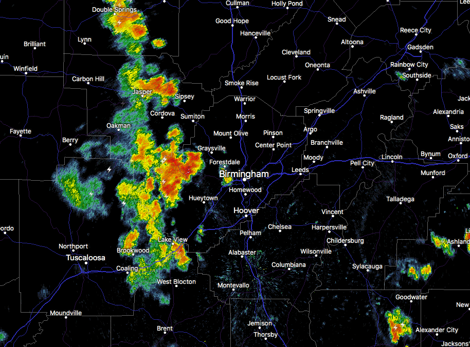
Radar check at 5:40 PM is showing a batch of thunderstorms moving into and through the western portions of Jefferson County from Tuscaloosa County and are about to move into the Birmingham metropolitan area within the next few minutes. Heavy rainfall now stretches from just south of West Jefferson down to just north of North Johns. Along with the heavy rain, a decent amount of cloud-to-ground lightning is occurring within the core of these storms.

At this point, this cluster of storms are the strongest on radar, but there are plenty of showers and storms throughout the area. Storms are stretching through the southern parts of Lawrence County down to Winston and Walker counties. These are moving slowly to the east.
Storms are diminishing somewhat over the eastern half of the area as they are struggling to move westward. These were developing from a low-level convergence zone that was struggling to move into the area from Georgia.
All of the activity is expected to die down after the sun sets and we lose the daytime heating. Most of the activity should be gone by 10:00 PM, but a few showers may hang on for a few hours longer into the late night and overnight hours.
Category: Alabama's Weather, ALL POSTS
About the Author (Author Profile)
Scott Martin is an operational meteorologist, professional graphic artist, musician, husband, and father. Not only is Scott a member of the National Weather Association, but he is also the Central Alabama Chapter of the NWA president. Scott is also the co-founder of Racecast Weather, which provides forecasts for many racing series across the USA. He also supplies forecasts for the BassMaster Elite Series events including the BassMaster Classic.Subscribe
If you enjoyed this article, subscribe to receive more just like it.


