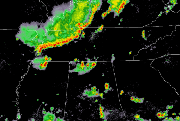
Latest Mesoscale Precipitation Discussion Includes Parts of North Alabama
An Mesoscale Convective System is making its way southward across northeastern Arkansas and northwestern Tennessee at the moment, and will eventually work its way into the northern parts of Alabama, including the northwestern counties of Central Alabama during the overnight and pre-dawn hours.
As the MCS continues to move southward, it will eventually lose it’s forward momentum and slow drastically. With precipitable water values nearing 2.00 inches in the northern part of the state, rainfall rates could be as high as 2.00 to 2.25 inches per hour under the heavier thunderstorms in the line. With the saturated nature of the soil, flash flooding will be possible under cells that have the tendency to train over the same locations.
Latest HRRR model solution shows the MCS reaching the northern parts of the state by 3:00-4:00 AM and moving into the extreme northern portions of Central Alabama by 8:00 AM.
Here is the text from the NWS WPC…
SUMMARY…A LINE OF THUNDERSTORMS WILL CONTINUE TO EXPAND AND
PROGRESS ACROSS THE LOWER OHIO AND WESTERN TENNESSEE VALLEY THIS
EVENING. THE STRONGEST CELLS WILL BE CAPABLE OF HOURLY RAINFALL
RATES OF 2-2.25″ THIS EVENING, WHICH IN SOME AREAS WHERE LOWER FFG
IS PRESENT, MAY LEAD TO FLASH FLOODING.
DISCUSSION…THE LATEST GOES-16 MESO2 VISIBLE AND WATER VAPOR
IMAGERY INDICATED THE REMNANT MESOSCALE-CONVECTIVE VORT CENTER
(MCV) ACROSS SOUTHERN IL, EAST OF SAINT LOUIS. DOWNSTREAM OF THIS
FEATURE, A FOCUSED AREA OF UPPER LEVEL DIVERGENCE IS ALLOWING FOR
WIDESPREAD CONVECTIVE DEVELOPMENT (QUASI-LINEAR) ACROSS PORTIONS
OF THE LOWER OH AND WESTERN TN VALLEYS. HELPING THE ACTIVITY TO
GROW UPSCALE IS THE STRONG AVAILABLE DEEP-LAYER INSTABILITY WITHIN
A FAVORABLY MOIST ENVIRONMENT. PER THE LATEST SPC MESOANALYSIS,
SURFACE-BASED CAPES RANGED BETWEEN 2500-3000 J/KG, WHILE PWATS HAD
CLIMBED BETWEEN 1.75-2.00 (OWING AT LEAST IN PART TO THE MESOSCALE
ENVIRONMENT).
THROUGH THIS EVENING, BASED ON THE CURRENT AND FORECAST WIND
PROFILES, EXPECT THE CONVECTION TO LOSE A BIT OF THE FORWARD OR
DOWNWIND PROPAGATION THAT HAD BEEN OBSERVED THROUGH 00Z. THIS
GIVEN THE BOOST IN SOUTHWESTERLY LOW-LEVEL INFLOW — CURRENTLY 20
KTS AND PER THE RAP, EXPECTED TO PEAK BETWEEN 25-30 KTS AFTER 01Z.
GIVEN THE WEAKER STEERING FLOW (WNW 850-300 MB MEAN FLOW 10-15
KTS), DO ANTICIPATE SOME CELL TRAINING ON THE SOUTH AND ESPECIALLY
SOUTHWEST PERIPHERY OF THE QLCS THIS EVENING. SUCH WOULD INCREASE
THE PROBABILITY OF HOURLY RAINFALL RATES OF 2-2.25+ INCHES,
ESPECIALLY GIVEN THE AFOREMENTIONED THERMODYNAMIC ENVIRONMENT.
BASED ON THE ANTECEDENT SOIL CONDITIONS (CURRENT 1 AND 3 HOURLY
FFG VALUES), FLASH FLOODING WILL BE POSSIBLE UNDERNEATH THE
STRONGEST THUNDERSTORMS AND/OR WHERE CELLS DO TRAIN.
Category: Alabama's Weather, ALL POSTS


