Rain & Storms In The North Just After Midday; Steamy In The South


CONDITIONS ACROSS NORTH/CENTRAL ALABAMA AT 12:35 PM
Plenty of clouds and rainfall over the northern and northwestern parts of of the area as we make our approach to the 1 o’clock hour. Moderate to heavy rain is falling over those parts of the area, with the rain being more scattered in nature over the northeastern locations. We even have a few showers moving through portions of Jefferson and Shelby counties, and a few reaching as far south as Sumter, Greene, and Hale counties. Much of the rain in the northwestern parts is moving to the south, while the other scattered showers are moving eastward at this time. Temperatures are currently in the mid to upper 80s in the south, while rain and clouds is keeping the north in the mid-70s to the mid-80s. Birmingham was at 78 degrees.
For the remainder of the afternoon and into the early evening hours, the large mass of rain over the northwestern parts of the area will continue to move southward, while the rest of North and Central Alabama will have a decent chance of scattered showers and thunderstorms. More lightning and heavier storms are expected to develop during the afternoon hour, and a few storms may become strong with gusty winds and a few small pebbles of hail. The main window for stronger storms will be from now until 10:00 PM tonight, but don’t be surprised that a few showers linger well after that until the late night and overnight hours. Afternoon highs will be held back by the rain and clouds in the northwest, only reaching the lower to mid-80s, while the rest of the area will be in the mid to upper 80s. Lows tonight will be in the upper 60s to the lower 70s. Some patchy fog can be expected especially in areas where a good bit of rain fell during the day.
A LITTLE DRIER ON THURSDAY, BUT SCATTERED STORMS STILL POSSIBLE
We’ll start to return back to a more typical summertime weather pattern on Thursday, with hot, hazy, and humid conditions and the chance of a scattered afternoon shower or storm. The chance of rain in the northwest half of Central Alabama will be around 20%-30%, while the southeastern half will range from 40%-60%. Skies will be mostly cloudy, but the sun make break through at times. Afternoon highs will be up in the upper 80s to the lower 90s.
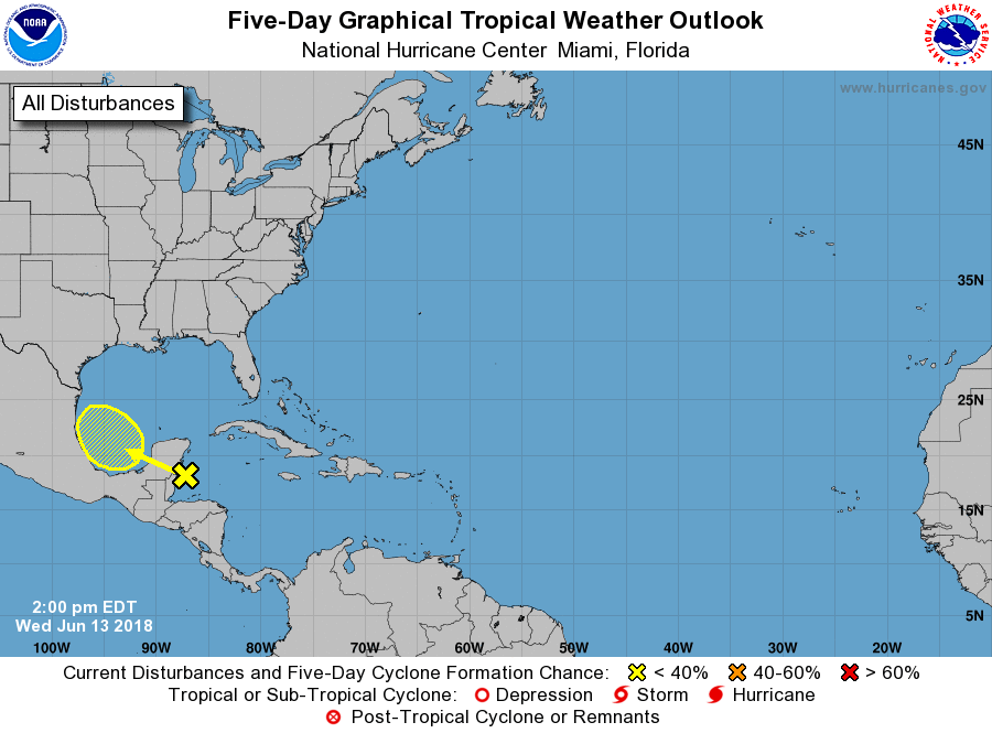
AN UPDATE ON THE TROPICS
An area of disturbed weather accompanied by strong gusty winds over the northwestern Caribbean Sea is forecast to move west-northwestward over Belize and the Yucatan Peninsula later tonight, and move into the southwestern Gulf of Mexico by Thursday afternoon. No development is expected for the next day or so due to land interaction with the Yucatan Peninsula and strong upper-level winds. However, environmental conditions could become slightly more conducive for some development of this disturbance while it moves across the southwestern Gulf of Mexico on Friday and Saturday. No threat to the US at this point. The rest of the North Atlantic, Caribbean Sea, and the Gulf of Mexico is calm.
BEACH FORECAST CENTER
Get the latest weather and rip current forecasts for the beaches from Fort Morgan to Panama City on our Beach Forecast Center page. There, you can select the forecast of the region that you are interested in.
WE’RE HAVING A RECORD-BREAKING YEAR… ADVERTISE WITH US TODAY!
Don’t miss out! We have enjoyed over 10.6 MILLION page views on AlabamaWx.com since the start of 2018. We can customize a creative, flexible and affordable package that will suit your organization’s needs. Contact Bill Murray at (205) 687-0782.
E-FORECAST
Get the AlabamaWx Weather Blog’s Seven-Day Forecast delivered directly to your inbox by email twice daily. It is the most detailed weather forecast available in Central Alabama. Subscribe here… It’s free!
WEATHERBRAINS
Don’t forget you can listen to our weekly 90 minute netcast anytime on the web at WeatherBrains.com or on iTunes. This is the show all about weather featuring many familiar voices, including the meteorologists at ABC 33/40.
ON THIS DAY IN WEATHER HISTORY
1989 – Thunderstorms produced severe weather from the Southern Plains Region to the Carolinas during the day and night, and continued to drench parts of Texas and Oklahoma with heavy rain. Oklahoma City reported 13.41 inches of rain for the first thirteen days of the month, and Fort Worth TX reported 29.56 inches for the year, a total more than 13 inches above normal. Severe drought continued to rage across South Texas.
Category: Alabama's Weather, ALL POSTS
About the Author (Author Profile)
Scott Martin is an operational meteorologist, professional graphic artist, musician, husband, and father. Not only is Scott a member of the National Weather Association, but he is also the Central Alabama Chapter of the NWA president. Scott is also the co-founder of Racecast Weather, which provides forecasts for many racing series across the USA. He also supplies forecasts for the BassMaster Elite Series events including the BassMaster Classic.Subscribe
If you enjoyed this article, subscribe to receive more just like it.


