Weather Update At 2:45 PM: Another Afternoon With Strong Storms
RADAR CHECK AT 2:45 PM
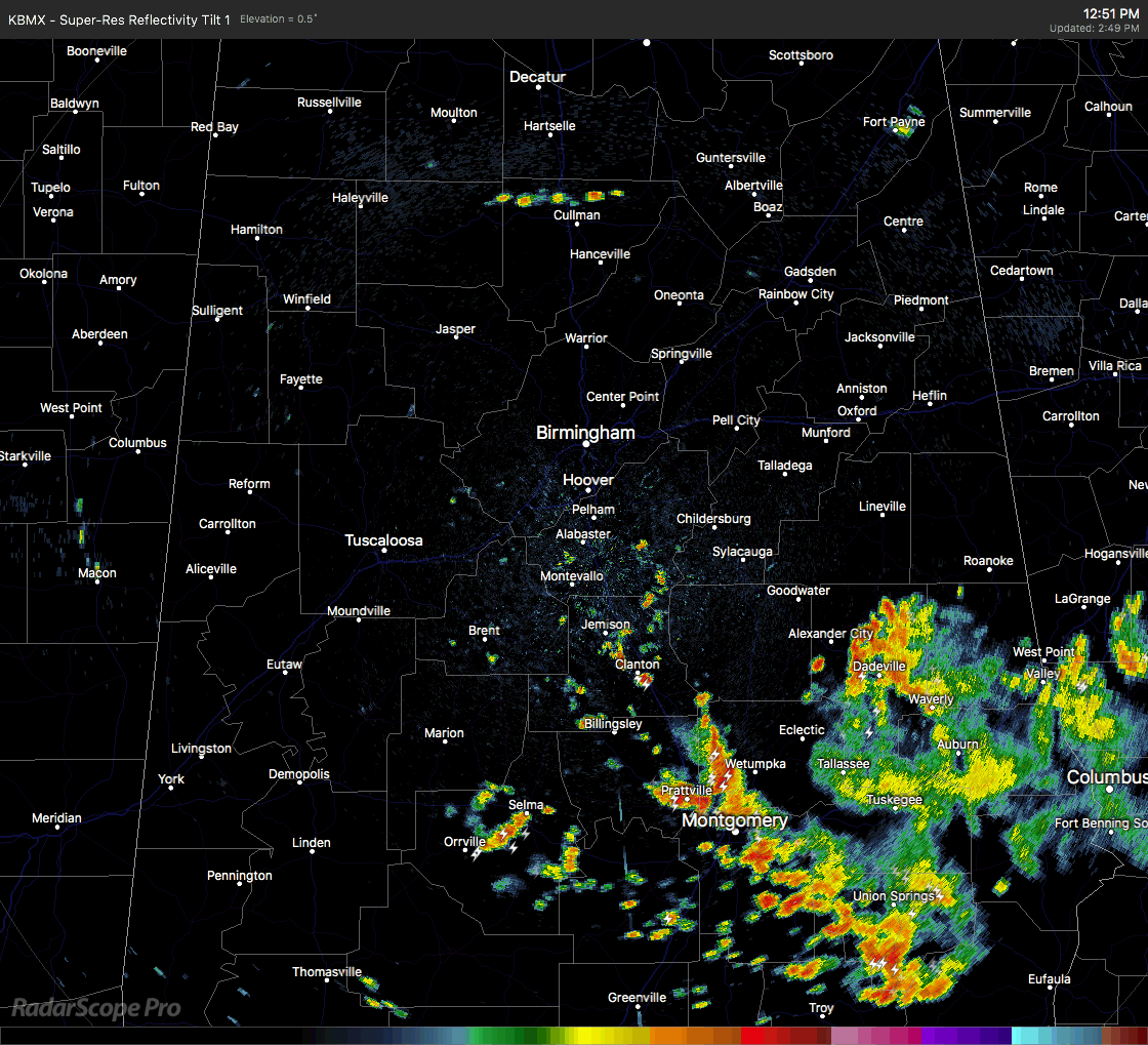
Well it’s another day with scattered strong storms across the North and Central Alabama area as we are entering the middle of the afternoon hours. The strongest on radar at this point is located over the eastern parts of Franklin County affecting Phil Campbell and Russellville. Some pea size hail and winds in excess of 30 MPH may be possible with this cluster of storms.
You can guarantee there is plenty of cloud-to-ground lightning and heavy downpours with these cells as they move to the west at 5 MPH. We may have to deal with some ponding and localized flash flooding considering it is barely moving.
There are other strong storms lined up from Alabaster down to Maplesville and Autaugaville that are also featuring plenty of cloud-to-ground lightning, heavy rainfall, and possible gusty winds.
Southeastern parts of Central Alabama has already seen enough rainfall for today, and the good news is that it looks like the rain is finally starting to diminish while moving out of the area. Parts of Lee and Russell counties have seen radar estimated amounts of 6-8 inches with some locally higher amounts approaching 10 inches (per NWS Birmingham).
We’ll continue with updates throughout the afternoon and evening hours until the thunderstorm activity calms down. Remember if you’re outside and you can hear thunder, you are close enough to the parent storm to be struck by lightning. Lightning can travel up to 10 miles from the parent cloud, but in some cases, can extend out much further. Back in 2007, Oklahoma experienced a lightning bolt that extended 200 miles, almost stretching from one side of the state to the other.
Category: Alabama's Weather, ALL POSTS
About the Author (Author Profile)
Scott Martin is an operational meteorologist, professional graphic artist, musician, husband, and father. Not only is Scott a member of the National Weather Association, but he is also the Central Alabama Chapter of the NWA president. Scott is also the co-founder of Racecast Weather, which provides forecasts for many racing series across the USA. He also supplies forecasts for the BassMaster Elite Series events including the BassMaster Classic.Subscribe
If you enjoyed this article, subscribe to receive more just like it.


